Sankt Pölten
city in Austria, capital of Lower Austria From Wikipedia, the free encyclopedia
Sankt Pölten (German pronunciation: [zaŋkt ˈpœltn̩] (![]() listen); East Central Austro-Bavarian: St. Pödn), mostly abbreviated to the official name St. Pölten,[3] is a city in Austria. It is a district of Lower Austria. Almost 58,000 people lived there (2023). It lies in the Mostviertel region. Since 1986, it has been the capital of Lower Austria. It is the biggest city of the Bundesland.
listen); East Central Austro-Bavarian: St. Pödn), mostly abbreviated to the official name St. Pölten,[3] is a city in Austria. It is a district of Lower Austria. Almost 58,000 people lived there (2023). It lies in the Mostviertel region. Since 1986, it has been the capital of Lower Austria. It is the biggest city of the Bundesland.
Sankt Pölten | |
|---|---|
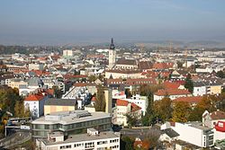
 A view of Sankt Pölten in 2005 | |
 Location of St. Pölten within Lower Austria | |
| Coordinates: 48°12′00″N 15°37′00″E | |
| Country | Austria |
| State | Lower Austria |
| District | Statutory city |
| Government | |
| • Mayor | Matthias Stadler (SPÖ) |
| Area | |
| • Total | 108.44 km2 (41.87 sq mi) |
| Elevation | 267 m (876 ft) |
| Population (2018-01-01)[2] | |
| • Total | 54,649 |
| • Density | 500/km2 (1,300/sq mi) |
| Time zone | UTC+1 (CET) |
| • Summer (DST) | UTC+2 (CEST) |
| Postal code | 3100, 3104, 3105, 3106, 3107, 3108, 3140, 3151, 3385 |
| Area code | 02742 |
| Vehicle registration | P |
| Website | www |
References
Other websites
Wikiwand in your browser!
Seamless Wikipedia browsing. On steroids.
Every time you click a link to Wikipedia, Wiktionary or Wikiquote in your browser's search results, it will show the modern Wikiwand interface.
Wikiwand extension is a five stars, simple, with minimum permission required to keep your browsing private, safe and transparent.


