Panama Canal Zone
former U.S. territory within the Republic of Panama From Wikipedia, the free encyclopedia
Panama Canal Zone Zona del Canal de Panamá | |||||||||
|---|---|---|---|---|---|---|---|---|---|
| 1903–1979 | |||||||||
| Motto: The Land Divided, The World United | |||||||||
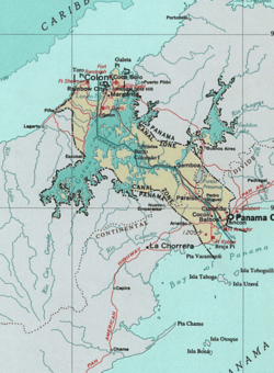
 Map of Panama Canal Zone. The Caribbean Sea is at the top left, the Gulf of Panama is at bottom right | |||||||||
| Status | International Concession of the United States | ||||||||
| Capital | Balboa | ||||||||
| Common languages | Spanish, English | ||||||||
| Demonym(s) | Zonian | ||||||||
| History | |||||||||
• Hay–Bunau-Varilla Treaty | November 18, 1903 | ||||||||
• Disestablished | October 1, 1979 | ||||||||
| Area | |||||||||
• Total | 1,432 km2 (553 sq mi) | ||||||||
| Currency | United States dollar Panamanian balboa (tolerated) | ||||||||
| |||||||||
| Today part of | Panama | ||||||||
The Panama Canal Zone (Spanish: Zona del Canal de Panamá) is a 553-square-mile (1,430 km2) former International concession of United States . It is now the country of Panama.
In 1903, the territory was controlled by the United States. As a part of the United States, the zone had several towns and military bases.
The Zone was disestablished in October 1, 1979 as part of a treaty signed in 1977 by President Jimmy Carter and Omar Torrijos, the unofficial leader of Panama.
The Panama Canal was operated by the United States until December 31, 1999, when it returned to Panama.
History
The treaty was approved by the provisional Panamanian government on December 2, 1903, and by the US Senate on February 23, 1903. While the treaty was approved, the Panamanians received US$10 million, much of which the United States required to be invested in that country. The Canal Zone was formally turned over by Panama on May 4, 1904, when American officials reopened the Panama City offices of the canal company and raised the American flag.[1]
Notable people
- John McCain – U.S. Senator from Arizona and the Republican nominee for President for the 2008 US presidential election
References
Wikiwand - on
Seamless Wikipedia browsing. On steroids.


