Hautes-Pyrénées
French department From Wikipedia, the free encyclopedia

Hautes-Pyrénées (Occitan: Nauts Pirenèus / Hauts Pirenèus) is a department in the southwest of France. It is part of the Occitanie region and its main city is Tarbes.
Hautes-Pyrénées | |
|---|---|
 Prefecture building of the Hautes-Pyrénées department, in Tarbes | |
 Flag  Coat of arms | |
 Location of Hautes-Pyrénées in France | |
| Coordinates: 43°12′N 0°8′E | |
| Country | France |
| Region | Occitanie |
| Département | 4 March 1790 |
| Prefecture | Tarbes |
| Subprefectures | Argelès-Gazost, Bagnères-de-Bigorre |
| Government | |
| • President | Michel Pélieu[1] |
| Area | |
| • Total | 4,464.0 km2 (1,723.6 sq mi) |
| Population (2014)[3] | |
| • Total | 228,950 |
| • Density | 51/km2 (130/sq mi) |
| Demonym | Haut-Pyrénéens / Bigourdans |
| Time zone | UTC+1 (CET) |
| • Summer (DST) | UTC+2 (CEST) |
| ISO 3166 code | FR-65 |
| Arrondissements | 3 |
| Cantons | 17 |
| Communes | 470 |
| Website | www.hautespyrenees.fr |
History
Hautes-Pyrénées is one of the original 83 departments created during the French Revolution on 4 March 1790. It was created with parts of the former province of Gascony; these parts were the old province of Bigorre and the Pays des Quatre-Vallées.[4]
Geography
Hautes-Pyrénées has an area of 4,464 km2 (1,724 sq mi), or 0.81% of the country.[5] It is part of the Occitanie region and has two small territorial exclaves—a remnant from the Middle Ages—located within the neighboring département of Pyrénées-Atlantiques.
The department is surrounded by 2 regions and 3 departments:
- Occitanie
- Gers to the north
- Haute-Garonne to the east
- Nouvelle-Aquitaine
- Pyrénées-Atlantiques to the west
and by Spain (the province of Huesca) to the south.

Three natural regions can be distinguished in the department.[5]
The Pyrénées, along the border with Spain, cover the southern half of the department, with 66% of the department. They form a natural barrier between France and Spain. More than 30 mountains here are over 3,000 m (9,800 ft) high.
The Pic Vignemale (42°46′26″N 0°8′51″E), at 3,299 m (10,823 ft), is the highest point of the department; it is on the border with Spain.[6] The Vignemale is in the Pyrénées National Park.
The second region of the Hautes-Pyrénées, with 17% of the territory, consists of chains low hills.
The third region, in the northern part of the department, is the plain of the Adour river and consists of largely flat agricultural land.
The main river of the department is the Adour river that flows through the cities of Tarbes and Bagnères-de-Bigorre. Other rivers are the Gave de Pau and the Neste.
Hautes-Pyrénées has two small territorial exclaves—a remnant from the Middle Ages—within the neighboring département of Pyrénées-Atlantiques.
Climate
The climate of the department is an oceanic climate with relatively hot summers, mild winters and abundant rainfall, Cfb in the Köppen climate classification.
The average amount of precipitation for the year in Lourdes is 1,005.8 mm (39.6 in). The month with the most precipitation on average is November with 109.2 mm (4.3 in) of precipitation. The month with the least precipitation on average is July with an average of 50.8 mm (2.0 in).[7]
The average temperature for the year in Lourdes is 11.8 °C (53.2 °F). The warmest month, on average, is July with an average temperature of 18.9 °C (66.0 °F). The coolest month on average is January, with an average temperature of 5 °C (41 °F).
| Climate data for Tarbes, France (altitude 360m, 1981–2010) (Source: Météo-France, Infoclimat.fr) | |||||||||||||
|---|---|---|---|---|---|---|---|---|---|---|---|---|---|
| Month | Jan | Feb | Mar | Apr | May | Jun | Jul | Aug | Sep | Oct | Nov | Dec | Year |
| Average high °C (°F) | 10.3 (50.5) |
11.3 (52.3) |
14.2 (57.6) |
15.8 (60.4) |
19.5 (67.1) |
22.8 (73.0) |
25.1 (77.2) |
25.2 (77.4) |
22.8 (73.0) |
19.0 (66.2) |
13.7 (56.7) |
11.0 (51.8) |
17.6 (63.7) |
| Average low °C (°F) | 1.0 (33.8) |
1.5 (34.7) |
3.7 (38.7) |
5.6 (42.1) |
9.5 (49.1) |
12.8 (55.0) |
14.9 (58.8) |
14.9 (58.8) |
11.9 (53.4) |
8.7 (47.7) |
4.3 (39.7) |
1.8 (35.2) |
7.6 (45.7) |
| Average precipitation mm (inches) | 95.0 (3.74) |
81.1 (3.19) |
87.0 (3.43) |
111.7 (4.40) |
111.6 (4.39) |
78.0 (3.07) |
56.0 (2.20) |
68.1 (2.68) |
71.6 (2.82) |
88.1 (3.47) |
102.5 (4.04) |
96.7 (3.81) |
1,047.4 (41.24) |
| Average precipitation days (≥ 1.0 mm) | 11 | 9 | 10 | 13 | 13 | 10 | 7 | 9 | 9 | 11 | 10 | 10 | 120 |
| Mean monthly sunshine hours | 118 | 129 | 169 | 170 | 189 | 198 | 205 | 206 | 190 | 151 | 117 | 109 | 1,951 |
| Source 1: climat.meteofrance.com[8] | |||||||||||||
| Source 2: infoclimat.fr[9] | |||||||||||||
Administration
The département is managed by the Departamental Council of the Haute-Garonne in Tarbes. The Hautes-Pyrénées is part of the region of Occitanie.
Administrative divisions
There are 3 arrondissements (districts), 17 cantons and 470 communes (municipalities) in the Hautes-Pyrénées.[10]
| INSEE code | Arrondissement | capital | Population[11] (2014) | Area[12] (km²) | Density (Inh./km²) | Communes |
|---|---|---|---|---|---|---|
| 651 | Argelès-Gazost | Argelès-Gazost | 38,813 | 1,300.2 | 29.9 | 87 |
| 652 | Bagnères-de-Bigorre | Bagnères-de-Bigorre | 46,384 | 1,675.7 | 27.7 | 171 |
| 653 | Tarbes | Tarbes | 143,753 | 1,488.1 | 96.6 | 212 |
The following is a list of the 17 cantons of the Hautes-Pyrénées department, following the French canton reorganisation which came into effect in March 2015:[13]
- Aureilhan (6501)
- Bordères-sur-l'Échez (6502)
- Les Coteaux (6503)
- La Haute-Bigorre (6504)
- Lourdes-1 (6505)
- Lourdes-2 (6506)
- Moyen Adour (6507)
- Neste, Aure et Louron (6508)
- Ossun (6509)
- Tarbes-1 (6510)
- Tarbes-2 (6511)
- Tarbes-3 (6512)
- Val d'Adour-Rustan-Madiranais (6513)
- La Vallée de l'Arros et des Baïses (6514)
- La Vallée de la Barousse (6515)
- La Vallée des Gaves (6516)
- Vic-en-Bigorre (6517)
Population
The inhabitants of Hautes-Pyrénées are known, in French, as Haut-Pyrénéens (women: Haut-Pyrénéennes).[14] They are also known as the Bigourdans.
Hautes-Pyrénées has a population, in 2014, of 228,950,[3] for a population density of 51.3 inhabitants/km2. The arrondissement of Tarbes, with 143,753 inhabitants, is by far the largest. The other two, Argelès-Gazost and Bagnères-de-Bigorre, have respectively 38,813 and 46,384 inhabitants.[11]
The city with more people living in it is the capital, Tarbes (40,900), followed by Lourdes (14,361). The subprefectures of Argelès-Gazost and Bagnères-de-Bigorre have, respectively, 3,020 and 7,602 inhabitants.[11]
Evolution of the population in Hautes-Pyrénées

The cities with more than 4,000 inhabitants in the department are:

| City | Population[11] (2014) |
Arrondissement |
|---|---|---|
| Tarbes | 40,900 | Tarbes |
| Lourdes | 14,361 | Argelès-Gazost |
| Aureilhan | 7,879 | Tarbes |
| Bagnères-de-Bigorre | 7,602 | Bagnères-de-Bigorre |
| Lannemezan | 5,912 | Bagnères-de-Bigorre |
| Vic-en-Bigorre | 5,004 | Tarbes |
| Bordères-sur-l'Échez | 4,879 | Tarbes |
| Séméac | 4,803 | Tarbes |
| Juillan | 4,104 | Tarbes |
Gallery
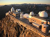 Pic du Midi de Bigorre
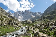
 Middle of Lake Bastan, shortly before sunset
 Cirque de Gavarnie


Related pages
References
Other websites
Wikiwand in your browser!
Seamless Wikipedia browsing. On steroids.
Every time you click a link to Wikipedia, Wiktionary or Wikiquote in your browser's search results, it will show the modern Wikiwand interface.
Wikiwand extension is a five stars, simple, with minimum permission required to keep your browsing private, safe and transparent.