Happurg
municipality in Landkreis Nürnberger Land in Germany From Wikipedia, the free encyclopedia
Happurg is a municipality in Nürnberger Land in Bavaria in Germany. During World War II, a subcamp of Flossenbürg concentration camp was placed here.[3]
Happurg | |
|---|---|
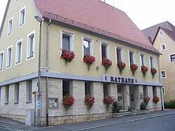
 Town hall | |
| Coordinates: 49°29′35″N 11°28′16″E | |
| Country | Germany |
| State | Bavaria |
| Admin. region | Mittelfranken |
| District | Nürnberger Land |
| Municipal assoc. | Happurg |
| Subdivisions | 14 Gemeindeteile |
| Government | |
| • Mayor (2020–26) | Bernd Bogner[1] (FW) |
| Area | |
| • Total | 42.59 km2 (16.44 sq mi) |
| Elevation | 353 m (1,158 ft) |
| Population (2022-12-31)[2] | |
| • Total | 3,755 |
| • Density | 88/km2 (230/sq mi) |
| Time zone | UTC+01:00 (CET) |
| • Summer (DST) | UTC+02:00 (CEST) |
| Postal codes | 91230 |
| Dialling codes | 09151 |
| Vehicle registration | LAU, ESB, HEB, N, PEG |
| Website | www.happurg.de |
Geography
Neighboring municipalities
Neighboring municipalities and communities (to the north going clockwise) are: Pommelsbrunn, Alfeld, Lauterhofen, Offenhausen, Engelthal, and Hersbruck.
Geographic location
The municipality is in the eastern part of the Franconian Jura
References
Wikiwand in your browser!
Seamless Wikipedia browsing. On steroids.
Every time you click a link to Wikipedia, Wiktionary or Wikiquote in your browser's search results, it will show the modern Wikiwand interface.
Wikiwand extension is a five stars, simple, with minimum permission required to keep your browsing private, safe and transparent.


