Grayson County, Kentucky
county in Kentucky, United States From Wikipedia, the free encyclopedia
county in Kentucky, United States From Wikipedia, the free encyclopedia
Grayson County is a county in the U.S. state of Kentucky. As of the 2020 census, the population was 26,420.[1] Its county seat is Leitchfield.[2]
Grayson County | |
|---|---|
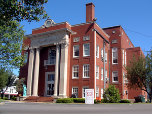
 Grayson County courthouse in Leitchfield | |
 Location within the U.S. state of Kentucky | |
 Kentucky's location within the U.S. | |
| Coordinates: 37°28′N 86°21′W | |
| Country | |
| State | |
| Founded | 1810 |
| Named for | William Grayson |
| Seat | Leitchfield |
| Largest city | Leitchfield |
| Area | |
| • Total | 511 sq mi (1,320 km2) |
| • Land | 497 sq mi (1,290 km2) |
| • Water | 14 sq mi (40 km2) 2.8% |
| Population (2020) | |
| • Total | 26,420 |
| • Density | 52/sq mi (20/km2) |
| Time zone | UTC−6 (Central) |
| • Summer (DST) | UTC−5 (CDT) |
| Congressional district | 2nd |
| Website | graysoncountyky |
Grayson County was formed in 1810 from land taken from Hardin and Ohio counties.[3] The county is named for William Grayson (1740-1790), a Revolutionary War colonel and U.S. Senator from Virginia.[4]
The county has a total area of 511 square miles (1,320 km2).[5]
Seamless Wikipedia browsing. On steroids.
Every time you click a link to Wikipedia, Wiktionary or Wikiquote in your browser's search results, it will show the modern Wikiwand interface.
Wikiwand extension is a five stars, simple, with minimum permission required to keep your browsing private, safe and transparent.