French overseas department and region in South America From Wikipedia, the free encyclopedia
French Guiana (French: Guyane) is an overseas department and region of France, on the north Atlantic coast of South America. By land area, it is the second largest region of France (after Nouvelle-Aquitaine) and the largest overseas department of France and of the European Union.
French Guiana
| |
|---|---|
| Territorial Collectivity of French Guiana Collectivité territoriale de Guyane (French) | |
|
Flag  Coat of arms | |
| Motto: Fert Aurum Industria | |
| Anthem: La Marseillaise ("The Marseillaise") | |
 | |
| Coordinates: 4°N 53°W | |
| Country | |
| Prefecture | Cayenne |
| Departments | 1 (every overseas region consists of a department in itself) |
| Government | |
| • Prefect | Thierry Queffelec[1] |
| • President of the Assembly | Gabriel Serville (Guyane Kontré pour avancer) |
| • Legislature | Assembly of French Guiana |
| Area | |
| • Total | 83,846 km2 (32,373 sq mi) |
| • Land | 83,534 km2 (32,253 sq mi) |
| • Rank | 2nd region and 1st department |
| Population (January 2022)[4] | |
| • Total | 294,436 |
| • Density | 3.5/km2 (9.1/sq mi) |
| Demonym(s) | French Guianan French Guianese |
| Time zone | UTC-3:00 (BRT) |
| ISO 3166 code |
|
| GDP (2019)[5] | Ranked 17th |
| Total | €4.41 billion (US$4.93 billion) |
| Per capita | €15,521 (US$17,375) |
| NUTS Region | FRA |
| Website | Territorial Collectivity Prefecture |
Its prefecture and largest city is Cayenne.
Guiana comes from an Amerindian language (Arawak) that means "land of many waters".[6] The addition of the word "French" in most languages other than French comes from colonial times when there were five in the region; they were, from west to east:
French Guiana and the two larger countries to the north and west, Guyana and Suriname, are still often collectively referred to as the Guianas and form the Guiana Shield.

French Guiana borders two countries: Surinam to the west, and Brazil to the east and south. To the north is the Atlantic Ocean. There are two main geographical regions: a coastal strip where the majority of the people live, and a dense rainforest which gradually rises to the modest peaks of the Tumuc-Humac mountains along the Brazilian frontier.
The highest point in the department is Bellevue de l'Inini Bellevue de l'Inini in the Maripasoula commune; it is (851 metres (2,792 feet)) high.[7] Other mountains are Mont Machalou (782 metres [2,566 feet]), Pic Coudreau (711 metres [2,333 feet]) and Mont St Marcel (635 metres [2,083 feet]).
Several small islands are found off the coast, the three Îles du Salut which include Devil's Island, and the isolated Îles du Connétable further along the coast towards Brazil.
The Petit-Saut Dam in the north of the department forms an artificial lake and provides hydroelectricity. There are many rivers in French Guiana.
It is the French department with more forests, 98% of the department is covered with an equatorial forest.[8]
As of 2007[update], the Amazon rainforest in the most southern part of the department, is protected as the Guiana Amazonian Park, one of the ten national parks of France. The territory of the park covers some 33,900 square kilometres (13,100 sq mi) in the communes of Camopi, Maripasoula, Papaïchton, Saint-Élie and Saül.
The climate in Cayenne, at an altitude of 9 metres (30 feet) above sea level, is of the subtype Af (Tropical Rainforest Climate also known as Equatorial Climate) in the Köppen climate classification.
The average temperature for the year in Cayenne is 26.7 °C (80.1 °F). The warmest month, on average, is September with an average temperature of 27.2 °C (81.0 °F). The coolest month on average is January, with an average temperature of 26.1 °C (79.0 °F).
The average amount of precipitation for the year in Cayenne is 3,205.5 millimetres (126.2 inches). The month with the most precipitation on average is May with 513.1 millimetres (20.2 inches) of precipitation. The month with the least precipitation on average is September with an average of 43.2 millimetres (1.7 inches). There is an average of 201.0 days of precipitation, with the most precipitation occurring in May with 27.0 days and the least precipitation occurring in September with 5.0 days.[9]
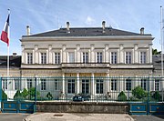
The department of French Guiana is managed by the Collectivité territorial de la Guyane in Cayenne.
There are 2 arrondissements (districts) and 22 communes (municipalities) in French Guiana.[10] The cantons of the department were eliminated on 31 December 2015 by the Law 2011-884 of 27 July 2011.[11]
| INSEE code | Arrondissement | Capital | Population[12] (2014) | Area[13] (km²) | Density (Inh./km²) | Communes |
|---|---|---|---|---|---|---|
| 9731 | Cayenne | Cayenne | 164,489 | 42,588.9 | 3.9 | 14 |
| 9732 | Saint-Laurent-du-Maroni | Saint-Laurent-du-Maroni | 87,849 | 40,945.0 | 2.1 | 8 |
The 22 communes in the department are:
| INSEE code | Commune | Population[12] (2014) | Area | Density (inh./km²) | Intercommunality |
|---|---|---|---|---|---|
| Arrondissement of Cayenne | |||||
| 97302 | Cayenne | 55,817 | 23.60 | 2,365.13 | Le Centre Littoral |
| 97307 | Matoury | 31,934 | 137.20 | 232.76 | Le Centre Littoral |
| 97304 | Kourou | 25,868 | 2,160.00 | 11.98 | Les Savanes |
| 97309 | Remire-Montjoly | 21,787 | 46.11 | 472.50 | Le Centre Littoral |
| 97305 | Macouria | 11,209 | 378.00 | 29.61 | Le Centre Littoral |
| 97308 | Saint-Georges | 3,960 | 2,320.00 | 1.71 | L'Est Guyanais |
| 97310 | Roura | 3,537 | 3,902.50 | 0.91 | Le Centre Littoral |
| 97312 | Sinnamary | 2,984 | 1,340.00 | 2.23 | Les Savanes |
| 97313 | Montsinéry-Tonnegrande | 2,477 | 737.20 | 3.36 | Le Centre Littoral |
| 97303 | Iracoubo | 1,931 | 2,762.00 | 0.70 | Les Savanes |
| 97356 | Camopi | 1,751 | 10030.00 | 0.17 | L'Est Guyanais |
| 97301 | Régina | 968 | 12130.00 | 0.08 | L'Est Guyanais |
| 97314 | Ouanary | 147 | 1,080.00 | 0.14 | L'Est Guyanais |
| 97358 | Saint-Élie | 119 | 5,680.00 | 0.02 | Les Savanes |
| Arrondissement of Saint-Laurent-du-Maroni | |||||
| 97311 | Saint-Laurent-du-Maroni | 44,169 | 4,830.00 | 9.14 | L'Ouest Guyanais |
| 97353 | Maripasoula | 10,984 | 18,360.00 | 0.60 | L'Ouest Guyanais |
| 97306 | Mana | 9,916 | 6,332.60 | 1.57 | L'Ouest Guyanais |
| 97360 | Apatou | 8,040 | 2,020.00 | 3.98 | L'Ouest Guyanais |
| 97357 | Grand-Santi | 6,656 | 2,123.00 | 3.14 | L'Ouest Guyanais |
| 97362 | Papaichton | 6,572 | 2628.00 | 2.50 | L'Ouest Guyanais |
| 97361 | Awala-Yalimapo | 1,364 | 187.40 | 7.28 | L'Ouest Guyanais |
| 97322 | Saül | 148 | 4,475.00 | 0.03 | L'Ouest Guyanais |
The inhabitants of French Guiana are known, in French, as Guyanais (women: Guyanaises).[14]
French Guiana has a population, in 2014, of 252,338,[15] for a population density of 3.0 inhabitants/km2. The city with more people living in it is the capital, Cayenne (55,817 inhabitants). The subprefecture of Saint-Laurent-du-Maroni has 44,169 inhabitants.[12]
Evolution of the population in French Guiana

The main traditional industries are fishing, gold mining and timber. The Guiana Space Centre of the European Space Agency has played a significant role in the local economy since it was established in Kourou in 1964.
Three Islands off the coast were used by the French Government from 1852 to 1953 as Prison Islands. They were:
Convicts who were sentenced to more than 8 years and survived and served their terms could not return to France but were required to stay on as involunatary settlers for the rest of their lives.
Famous Inmates:
.jpg)