File:Philippines_relief_location_map.jpg
From Wikipedia, the free encyclopedia
Size of this preview: 454 × 599 pixels. Other resolutions: 182 × 240 pixels | 364 × 480 pixels | 582 × 768 pixels | 776 × 1,024 pixels | 1,871 × 2,468 pixels.
Original file (1,871 × 2,468 pixels, file size: 1.23 MB, MIME type: image/jpeg)
| This is a file from the Wikimedia Commons. Information from its description page there is shown below. Commons is a freely licensed media file repository. You can help. |
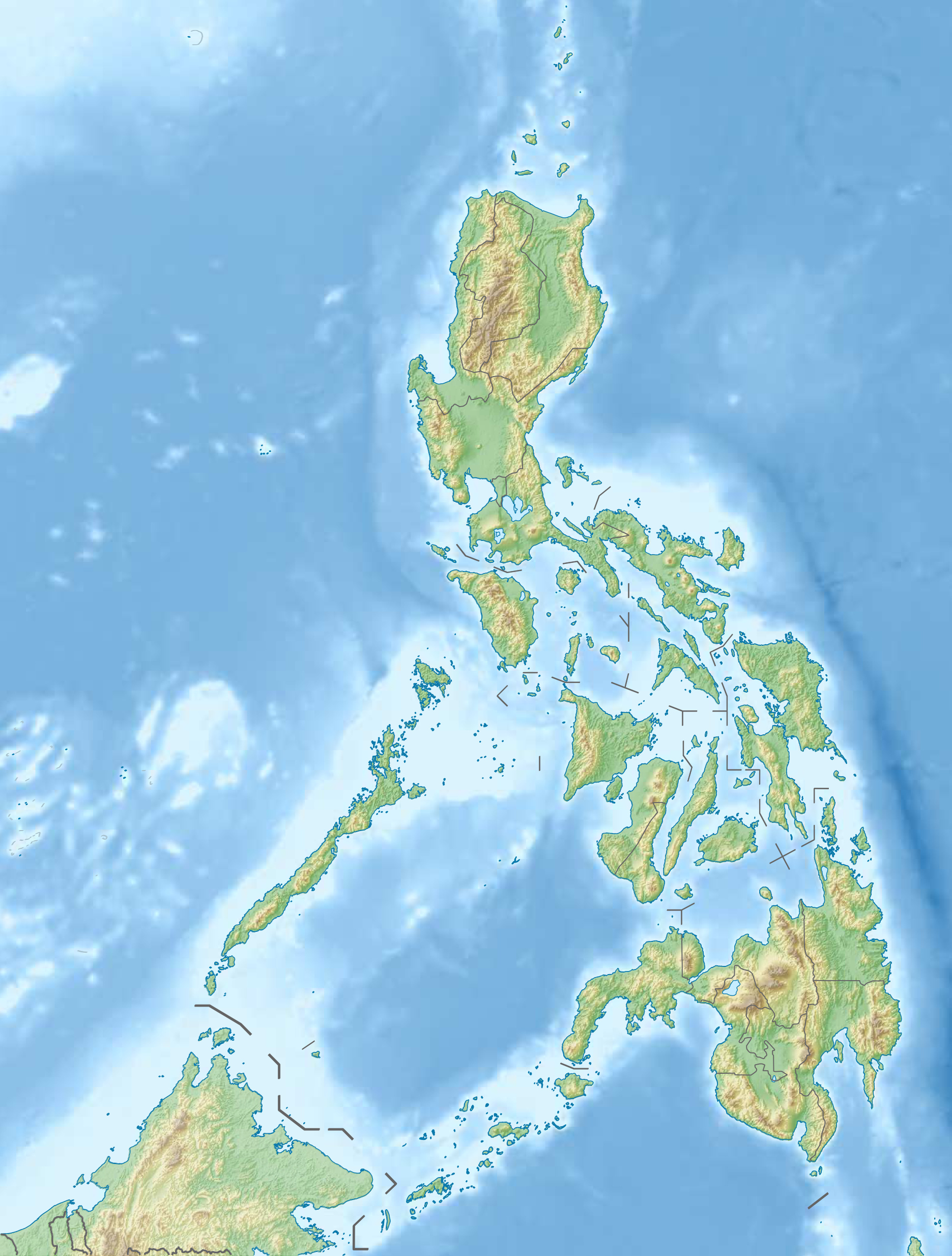
| DescriptionPhilippines relief location map.jpg |
Deutsch: Physische Positionskarte der Philippinen
Quadratische Plattkarte, N-S-Streckung 103 %. Geographische Begrenzung der Karte:
English: Physical location map of the Philippines
Equirectangular projection, N/S stretching 103 %. Geographic limits of the map:
|
| Date | |
| Source |
Own work, using
|
| Author | Carport |
| Permission (Reusing this file) |
This file is licensed under the Creative Commons Attribution-Share Alike 3.0 Unported license.
|
| Other versions |
Derivative works of this file: 2013 Lahad Datu standoff.svg
|


|
File:Philippines relief location map (square).svg is a vector version of this file. It should be used in place of this JPG file when not inferior.
File:Philippines relief location map.jpg → File:Philippines relief location map (square).svg
For more information, see Help:SVG.
|
.svg) |
Captions
Add a one-line explanation of what this file represents
Items portrayed in this file
depicts
14 December 2012
File history
Click on a date/time to view the file as it appeared at that time.
| Date/Time | Thumbnail | Dimensions | User | Comment | |
|---|---|---|---|---|---|
| current | 15:07, 31 December 2012 | | 1,871 × 2,468 (1.23 MB) | Carport | {{Information |Description= {{de|Physische Positionskarte der Philippinen}} Quadratische Plattkarte, N-S-Streckung 103 %. Geographische Begrenzung der Karte: * N: 21.2° N * S: 4.3° N * W: 114.1° O * O: 127.3° O {{en|Physical loc... |
File usage
There are no pages that use this file.
Global file usage
The following other wikis use this file:
- Usage on az.wikipedia.org
- Jolo adası
- Apo dağı
- Şablon:Yer xəritəsi Filippin
- Suriqao boğazı
- Luzon boğazı
- Kamotes dənizi
- Luson adası
- Mindanao
- Tayabas bərzəxi
- Samar
- Leyte
- Mindoro
- Luzon adaları
- Palavan
- Panay
- Neqros
- Visay adaları
- Mindanao adaları
- Batan adası
- Tubabao
- Marinduke
- Bohol
- Lubanq adası
- Romblon adası
- Biliran adası
- Borakay
- Maktan adası
- Siarqao adası
- Babuyan arxipelaqı
- Panqlao
- Lubanq arxipelaqı
- Mastabe adası
- Sibutu adası
- Sulu arxipelaqı
- Kalamian adaları
- Basilan
- Koron adası
- Sibuyan adası
- Bohol adası
- Sebu adası
- Leonard Knyazev vulkanı
- Taal gölü
- Usage on bar.wikipedia.org
- Usage on be.wikipedia.org
View more global usage of this file.