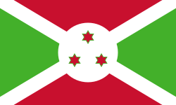
Burundi
sovereign state in Africa From Wikipedia, the free encyclopedia
Burundi (officially called the Republic of Burundi) is a small country in Africa. The capital of Burundi is Gitega. The official languages of Burundi are Kirundi, Swahili, French and English. There are about 14 million people in Burundi. Burundi is one of the poorest countries in the world.
Republic of Burundi | |
|---|---|
Motto:
| |
| Anthem: "Burundi Bwacu" (Kirundi) "Our Burundi" | |
 Location of Burundi (dark blue)
in Africa (light blue) | |
| Capital | Gitega 3°30′S 30°00′E |
| Largest city | Bujumbura |
| Official languages | |
| Ethnic groups | |
| Religion (2020)[1] |
|
| Demonym(s) | Burundian |
| Government | Unitary dominant-party presidential republic under an authoritarian dictatorship[2][3][4] |
| Évariste Ndayishimiye[5] | |
| Gervais Ndirakobuca | |
• Vice President | Prosper Bazombanza |
| Legislature | Parliament |
| Senate | |
| National Assembly | |
| Establishment history | |
| 1680–1966 | |
• Part of German East Africa | 1890–1916 |
• Part of Ruanda-Urundi | 1916–1962 |
• Independence from Belgium | 1 July 1962 |
• Republic | 28 November 1966 |
• Current constitution | 17 May 2018 |
| Area | |
• Total | 27,834 km2 (10,747 sq mi)[7] (142nd) |
• Water (%) | 10[8] |
| Population | |
• 2024 estimate | 14,151,540 [9] (78th) |
• Density | 473/km2 (1,225.1/sq mi) (17th) |
| GDP (PPP) | 2023 estimate |
• Total | $12.594 billion[10] (164th) |
• Per capita | $890[10] (193rd) |
| GDP (nominal) | 2023 estimate |
• Total | $3.184 billion[10] (173rd) |
• Per capita | $322[10] (192nd) |
| Gini (2020) | 37.5[11] medium |
| HDI (2022) | 0.420[12] low · 187th |
| Currency | Burundian franc (FBu) (BIF) |
| Time zone | UTC+2 (CAT) |
| Driving side | right |
| Calling code | +257 |
| ISO 3166 code | BI |
| Internet TLD | .bi |
History
In 1962, Burundi gained independence from Belgium.[13]
Provinces, communes and collines
Burundi is divided into 18 provinces, 117 communes, and 2,638 collines (hills).[14] Provincial governments are based on these boundaries.[15]
The provinces are:
Largest cities
These are the largest cities in Burundi:
Geography
One of the smallest countries in Africa, Burundi is landlocked. It is bordered by Rwanda to the north, Tanzania to the east and south and the Democratic Republic of the Congo to the west. It has an equatorial climate. Burundi is a part of the Albertine Rift, the western extension of the East African Rift.
The country lies on a rolling plateau in the center of Africa. The average elevation of the central plateau is 5,600 feet (1,707 m), with lower elevations at the borders. The highest peak, Mount Heha at 8,810 feet (2,685 m),[16] is southeast of Bujumbura. The source of the Nile River is in Burundi province. It is linked from Lake Victoria to its headwaters by the Ruvyironza River.[17] Lake Victoria is also an important water source. It serves as a fork to the Kagera River.[18][19] Another major lake is Lake Tanganyika in Burundi's southwestern corner.[20]
Burundi's lands are mostly agricultural or pasture. Settlement by rural populations has led to deforestation, soil erosion, and habitat loss.[21]
There are two national parks: Kibira National Park and Ruvubu National Park. Both were formed in 1982 to keep wildlife populations.[22]
Related pages
References
Other websites
Wikiwand - on
Seamless Wikipedia browsing. On steroids.


