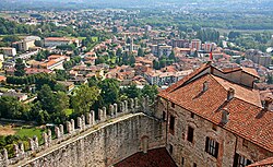
Angera is a comune in the Province of Varese, in the Lombardy region in northern Italy. As of 31 December 2011, 5,622 people lived there.
Angera | |
|---|---|
| Comune di Angera | |
 | |
| Coordinates: 45°46′N 08°35′E | |
| Country | Italy |
| Region | Lombardy |
| Province | Varese (VA) |
| Frazioni | Capronno, Barzola |
| Government | |
| • Mayor | Marcella Androni |
| Area | |
| • Total | 17.72 km2 (6.84 sq mi) |
| Elevation | 193 m (633 ft) |
| Population (31 December 2011)[2] | |
| • Total | 5,622 |
| • Density | 320/km2 (820/sq mi) |
| Demonym | Angeresi |
| Time zone | UTC+1 (CET) |
| • Summer (DST) | UTC+2 (CEST) |
| Postal code | 21021 |
| Dialing code | 0331 |
| Patron saint | Santa Maria Assunta |
| Saint day | 15 August |
| Official website | |
References
Wikiwand in your browser!
Seamless Wikipedia browsing. On steroids.
Every time you click a link to Wikipedia, Wiktionary or Wikiquote in your browser's search results, it will show the modern Wikiwand interface.
Wikiwand extension is a five stars, simple, with minimum permission required to keep your browsing private, safe and transparent.


