File:Europe_map_220BC.PNG
From Wikipedia, the free encyclopedia
මෙම පෙරදසුනෙහි විශාලත්වය: 628 × 599 පික්සල. අනෙකුත් විභේදනයන්: 251 × 240 පික්සල | 503 × 480 පික්සල | 805 × 768 පික්සල | 1,143 × 1,091 පික්සල.
මුල් ගොනුව (1,143 × 1,091 පික්සල, ගොනු විශාලත්වය: 77 කි.බ., MIME ශෛලිය: image/png)
මෙම ගොනුව Wikimedia Commons වෙතින් වන අතර අනෙකුත් ව්යාපෘතීන් විසින්ද භාවිතා කල හැක. එහි ගොනු විස්තර පිටුව තුල අඩංගු විස්තර මෙහි පහත දැක්වෙයි.
සාරාංශය
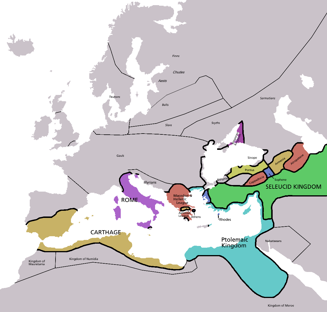
| විස්තරයEurope map 220BC.PNG | Map of Europe in 220BC, based on free map of europe Image:BlankMap-Europe.png. Many of the border lines are approximations. |
| දිනය | |
| මූලාශ්රය | The Penguin Atlas of Ancient History |
| කර්තෘ | Astrokey44 |
| අනෙකුත් අනුවාදයන් | map without text, map in french |

|
This historical map image could be re-created using vector graphics as an SVG file. This has several advantages; see Commons:Media for cleanup for more information. If an SVG form of this image is available, please upload it and afterwards replace this template with
{{vector version available|new image name}}.
It is recommended to name the SVG file “Europe map 220BC.svg”—then the template Vector version available (or Vva) does not need the new image name parameter. |
_en.png)
.png)
.jpg)
බලපත්රීකරණය

|
Free Software Foundation විසින් ප්රකාශිත GNU Free Documentation License බලපත්රයෙහි 1.2 හෝ ඊට අලුත් පිටපත්වල කොන්දේසිවලට යටත්ව මෙම ගොනුව පිටපත් කෙරුමට, නැවත බෙදාහාරුමට සහ/හෝ වෙනස් කෙරුමට අවසර දී ඇත; ඒ වෙනස් අංශ නොමැතිව, මුල් පිටු පෙළ නොමැතිව, පසු පිටු පෙළ නොමැතිවය. බලපත්රයේ පිටපතක් GNU Free Documentation License නම් අංශයේ දැක්වේ.http://www.gnu.org/copyleft/fdl.htmlGFDLGNU Free Documentation Licensetruetrue |
| මෙම ගොනුව ක්රියේටිව් කොමන්ස් Attribution-Share Alike 3.0 Unported වරපත යටතේ අවසර ලබා ඇත. | ||
| ||
| GFDL බලපත්ර යාවත්කාල කෙරුමහි කොටසක් ලෙස මෙම ගොනුවට බලපත්ර ටැගය එක් කෙරිනි.http://creativecommons.org/licenses/by-sa/3.0/CC BY-SA 3.0Creative Commons Attribution-Share Alike 3.0truetrue |
Captions
මෙම ගොනුව නිරූපණය කරන්නෙඑ කුමක්දැයි තනි පේළියේ පැහැදිළි කිරීමක් එක් කරන්න.
Items portrayed in this file
depicts ඉංග්රීසි
copyright status ඉංග්රීසි
copyrighted ඉංග්රීසි
inception ඉංග්රීසි
12 ජනවාරි 2007
ගොනු ඉතිහාසය
එම අවස්ථාවෙහිදී ගොනුව පැවැති ආකාරය නැරඹීමට දිනය/වේලාව මත ක්ලික් කරන්න.
| දිනය/වේලාව | කුඩා-රූපය | මාන | පරිශීලක | පරිකථනය | |
|---|---|---|---|---|---|
| වත්මන් | 05:28, 8 පෙබරවාරි 2011 | | 1,143 × 1,091 (77 කි.බ.) | Swarm | Correcting borders of Rome |
| 22:20, 4 අප්රේල් 2009 |  | 1,143 × 1,091 (80 කි.බ.) | DJ Sturm | Detailed Finnic peoples | |
| 03:02, 12 ජනවාරි 2007 |  | 1,143 × 1,091 (41 කි.බ.) | Roke~commonswiki | ||
| 01:38, 5 මැයි 2006 |  | 2,285 × 2,181 (140 කි.බ.) | Roke~commonswiki | Map of Europe in 220BC, based on free map of europe Image:BlankMap-Europe.png Category: Historical maps of Europe |
ගොනු භාවිතය
මෙම ගොනුව භාවිතා කරන නිසිදු පිටුවක් නොමැත.
ගෝලීය ගොනු භාවිතය
පහත දැක්වෙන අනෙකුත් විකියන් මගින් මෙම ගොනුව භාවිතා කරයි:
- ar.wikipedia.org හි භාවිතය
- ba.wikipedia.org හි භාවිතය
- bn.wikipedia.org හි භාවිතය
- ca.wikipedia.org හි භාවිතය
- cv.wikipedia.org හි භාවිතය
- da.wikipedia.org හි භාවිතය
- el.wikipedia.org හි භාවිතය
- en.wikipedia.org හි භාවිතය
- fr.wikipedia.org හි භාවිතය
- fy.wikipedia.org හි භාවිතය
- hu.wikipedia.org හි භාවිතය
- hy.wikipedia.org හි භාවිතය
- hyw.wikipedia.org හි භාවිතය
- id.wikibooks.org හි භාවිතය
- ko.wikipedia.org හි භාවිතය
- nl.wikipedia.org හි භාවිතය
- no.wikipedia.org හි භාවිතය
- pl.wikipedia.org හි භාවිතය
- pt.wikipedia.org හි භාවිතය
- ru.wikipedia.org හි භාවිතය
- sh.wikipedia.org හි භාවිතය
- simple.wikipedia.org හි භාවිතය
- sv.wikipedia.org හි භාවිතය
- th.wikipedia.org හි භාවිතය
පාරදත්ත
සමහරවිට ඩිජිටල් කැමරාවක් හෝ ස්කෑනරයක් හෝ භාවිතයෙන්, නිමැවා හෝ සංඛ්යාංකකරණය (ඩිජිටල්කරණය) කොට එක් කල , අමතර තොරතුරු මෙම ගොනුවේ අඩංගුය.
ගොනුව මුලින්ම පැවැති තත්ත්වයෙහි සිට විකරණය කොට තිබේ නම්, සමහරක් තොරතුරු විකරිත ගොනුව පූර්ණ වශයෙන් පිළිඹිමු නොකරනු ඇත.
| තිරස් විභේදනය | 37.79 dpc |
|---|---|
| සිරස් විභේදනය | 37.79 dpc |
"https://si.wikipedia.org/wiki/ගොනුව:Europe_map_220BC.PNG" වෙතින් සම්ප්රවේශනය කෙරිණි