File:Roman_Empire_with_dioceses_in_400_AD.png
From Wikipedia, the free encyclopedia
هن پيش-نگاھ جي ماپ: 800*550 پڪزلس. ٻيا تحلل:320*220 پڪزلس | 640*440 پڪزلس | 1,024*704 پڪزلس | 1,280*880 پڪزلس | 2,042*1,404 پڪزلس
اصلوڪو فائيل (2,042 × 1,404 عڪسلون، فائيل سائيز: 191 KB، MIME ٽائيپ: image/png)
ھي فائيل وڪيميڊيا العام مان آھي ۽ ٻين رٿائن پاران پڻ استعمال ٿي سگهي ٿو. تشريح انجي [فائيل جي تشريحي صفحي] ھيٺان ڏنل آھي.
تَتُ
| تشريحRoman Empire with dioceses in 400 AD.png |
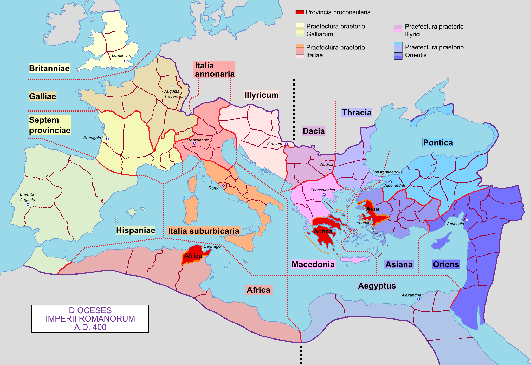
English: Map of the Roman Empire with its dioceses, in 400 AD.
Français : Carte de l'Empire romain avec ses diocèses, en 400 ap. J.-C. |
| تاريخ | 04/03/09 |
| ذريعو | ڪم پنھنجايو |
| ليکڪ | Mandrak |
| Other versions | Blank map : File:Blank Roman Empire.png |
لائيسنسڪاري
| Public domainPublic domainfalsefalse |
| I, the copyright holder of this work, release this work into the public domain. This applies worldwide. In some countries this may not be legally possible; if so: I grant anyone the right to use this work for any purpose, without any conditions, unless such conditions are required by law. |
عنوان
ھڪ-سٽي وضاحت ڏيو تہ ھي فائيل ڇاکي ٿو ظاھر ڪري
Items portrayed in this file
depicts انگريزي
creator انگريزي
some value
source of file انگريزي
original creation by uploader انگريزي
فائيل جي سوانح
ڪنھن بہ تاريخ/وقت تي ٽڙڪ ڪري ڏسندا تہ ان وقت اهو فائيل ڪيئن هو.
| تاريخ/وقت | آڱوٺي ننھن | ماپَ | واپرائيندڙ | راءِ | |
|---|---|---|---|---|---|
| موجود نسخو | 17:52, 29 نومبر 2019 | | 2,042 × 1,404 (191 KB) | Claude Zygiel | Chersones (antic Crimea) |
| 18:47, 28 ڊسمبر 2011 |  | 2,042 × 1,404 (183 KB) | Ras67 | cropped and optimized | |
| 12:32, 10 مارچ 2009 |  | 2,052 × 1,414 (273 KB) | Mandrak | Erreurs corrigées. | |
| 12:56, 4 مارچ 2009 |  | 2,052 × 1,414 (271 KB) | Mandrak | Erreur : ''Antiocha'' corrigée en ''Antiochia'' | |
| 11:53, 4 مارچ 2009 |  | 2,052 × 1,414 (271 KB) | Mandrak | {{Information |Description={{en|1=Map of the Roman Empire with its dioceses, in 400 AD.}} {{fr|1=Carte de l'Empire romain avec ses diocèses, en 400 ap. J.-C.}} |Source=travail personnel (own work) |Author=Mandrak |Date=04/03/09 |Permissi |
ڳنڍڻا
ڪي بہ صفحا ناھن جيڪي ھن فائيل کي استعمال ڪندا ھجن.
گلوبل فائيل جو استعمال
ھيٺيون وڪيز بہ ھيءُ فائيل استعمال ڪن ٿيون:
- ar.wikipedia.org تي استعمال
- ast.wikipedia.org تي استعمال
- bg.wikipedia.org تي استعمال
- br.wikipedia.org تي استعمال
- cs.wikipedia.org تي استعمال
- de.wikipedia.org تي استعمال
- Augustinus von Hippo
- 395
- Geschichte Spaniens
- Spätantike
- Notitia dignitatum
- Moesia inferior
- Reichsteilung von 395
- Dioecesis
- Benutzer:Methodios/Ninian von Withorn
- Dioecesis Orientis
- Dioecesis Pontica
- Dioecesis Asiana
- Dioecesis Thraciarum
- Dioecesis Pannoniae
- Dioecesis Africae
- Dioecesis Britanniae
- Dioecesis Galliae
- Dioecesis Septem Provinciarum
- Dioecesis Hispaniae
- Dioecesis Italiae Annonariae
- Dioecesis Italiae Suburbicariae
- Dioecesis Daciae
- Dioecesis Macedoniae
- Orestes (Präfekt)
- Byzantinische Herrschaft im Maghreb
- Römisches Italien
- de.wikibooks.org تي استعمال
- de.wikiversity.org تي استعمال
- el.wikipedia.org تي استعمال
- en.wikipedia.org تي استعمال
ھن فائيل جو وڌيڪ گلوبل استعمال ڏسو.
اعدادِ اعداد
هن فائيل ۾ وڌيڪ ڄاڻ موجود آهي، جيڪا ڪنھن ڊجيٽل ڪيمرا يا اسڪينر کان وڌي وئي آهي، جنھن سان هي عڪس سرجيو يا چٽيو ويو آهي.
جيڪڏهن فائيل بدلايو ويو آھي تہ پوءِ ڪجهہ ڄاڻ تفصيل سڄي تبديل ٿيل فائيل کي متان ظاھر نہ ڪري.
| افقي تحلل | 28.35 dpc |
|---|---|
| عمودي تحلل | 28.35 dpc |