Map Graph

Haiti

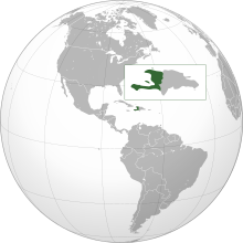
Haiti, offeecially the Republic o Haiti is a Caribbean kintra. It occupies the wastren, smawer portion o the island o Hispaniola, in the Greater Antillean archipelago, which it shares wi the Dominican Republic. Ayiti wis the indigenous Taíno or Amerindian name for the muntainous wastren side o the island. The kintra's heichest pynt is Pic la Selle, at 2,680 metres (8,793 ft). The tot area o Haiti is 27,750 square kilometres an its caipital is Port-au-Prince. French an Haitian Creole are the offeecial leids.

Read article
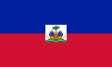
File:Flag_of_Haiti.svgFile:Coat_of_arms_of_Haiti.svgFile:Haiti_(orthographic_projection).svgFile:Haiti_-_Location_Map_(2013)_-_HTI_-_UNOCHA.svgFile:Haiti_with_departments_borders_(numbered).svgFile:Jérémie_haïti_3.JPGFile:HaitianPresidentialPalace.jpgFile:Cour-de-cassation-haiti-actunews7.jpgFile:Cathedral_Les_Cayes_Haiti.jpgFile:Universite_henrichristophe.jpgFile:Le_Marron_Inconnu_-_April_2018_front_2.jpgFile:Villa_Miramar,_Port-au-Prince_20180716_02.jpgFile:Hispaniolan_Trogon_(Priotelus_roseigaster)_(8082768540).jpgFile:Citadelle_Laferrière_Aerial_View.jpgFile:Harbour_Petite_Riviere_de_Nippes_Haiti.jpgFile:Amid_rows_of_cabbage,_Haiti.jpg