File:Relief_Map_of_Czech_Republic.png
From Wikipedia, the free encyclopedia
Size o this luikower: 800 × 486 pixels. Ither resolutions: 320 × 195 pixels | 640 × 389 pixels | 1,000 × 608 pixels.
Oreeginal file (1,000 × 608 pixels, file size: 866 KB, MIME type: image/png)
This file is fae Wikimedia Commons n micht be uised bi ither waurks. The descreeption oan its file descreeption page thaur is shawn ablo.
Ootline
| DescreeptionRelief Map of Czech Republic.png |
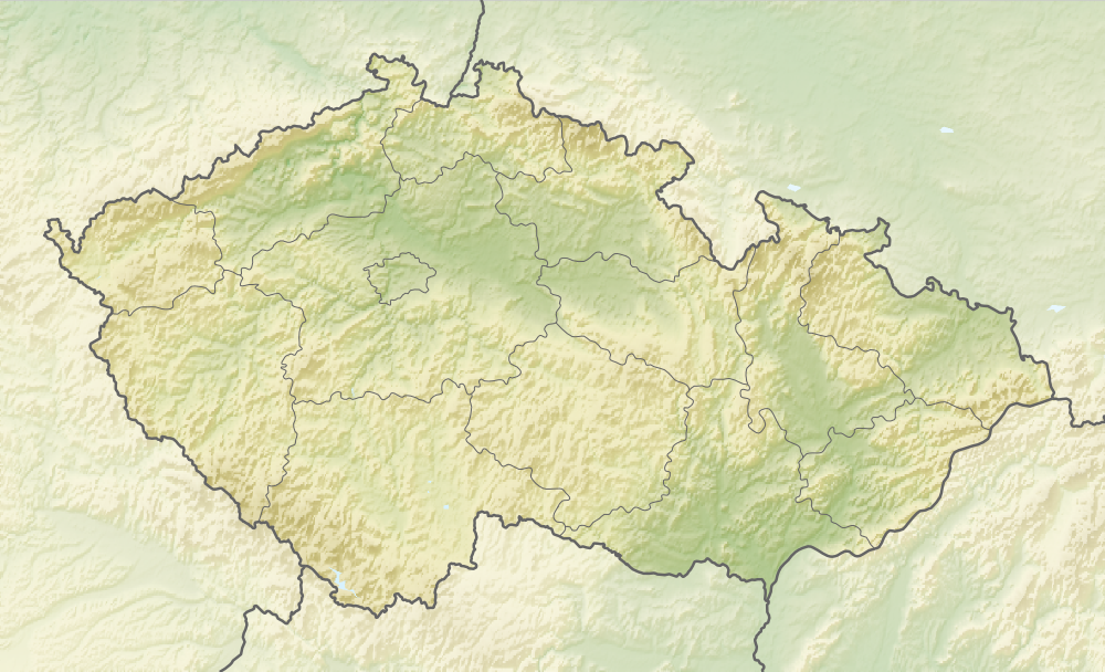
English: Relief map of the Czech Republic
Equirectangular projection, N/S stretching 150 %. Geographic limits of the map:
|
| Date | |
| Soorce |
|
| Author | derivative work Виктор_В |
Licensin
This file is licensed unner the Creative Commons Attribution-Share Alike 3.0 Unported license.
- Ye are free:
- tae share – tae copy, distribute an transmit the wirk
- tae remix – tae adapt the wirk
- Unner the follaein condeetions:
- attribution – Ye must attribute the wirk in the manner specified bi the author or licensor (but nae in ony way that suggests that thay endorse ye or yer uise o the wirk).
- share alik – If ye alter, transform, or big upon this wirk, ye mey distribute the resultin wirk anly unner the same or seemilar license tae this ane.
Captions
Add a one-line explanation of what this file represents
Relief map of Czechia
Items portrayed in this file
depicts
relief map Inglis
copyright status Inglis
copyrighted Inglis
28 August 2010
image/png
File history
Clap oan ae date/time fer tae see the file aes it kithed at that time.
| Date/Time | Thummnail | Dimensions | Uiser | Comment | |
|---|---|---|---|---|---|
| current | 08:37, 11 Januar 2021 | | 1,000 × 608 (866 KB) | ThecentreCZ | Reverted to version as of 11:53, 28 August 2010 (UTC) V Ústavním pořádku České republiky nemají zemské hranice žádné ukotvení a jsou jen přežitkem |
| 22:48, 10 Januar 2021 |  | 1,000 × 608 (780 KB) | Osidor | přidány zemské hranice (důvod: na mapě jsou užitečné nejméně stejně jako ty krajské [spíše však více]) | |
| 11:53, 28 August 2010 |  | 1,000 × 608 (866 KB) | Виктор В | == {{int:filedesc}} == {{Information |Description={{en|Location map of the Czech Republic}} Equirectangular projection, N/S stretching 150 %. Geographic limits of the map: * N: 51.3° N * S: 48.3° N * W: 11.8° E * O: 19.2° |
Eimage airtins
The follaein pages airts tae this image:
Global file uisage
The follaein ither wikis uise this file:
- Uisage on als.wikipedia.org
- Uisage on arz.wikipedia.org
- Uisage on ast.wikipedia.org
- Uisage on azb.wikipedia.org
- Uisage on az.wikipedia.org
- Uisage on bar.wikipedia.org
- Uisage on ba.wikipedia.org
- Uisage on be-tarask.wikipedia.org
- Uisage on be.wikipedia.org
- Uisage on bg.wikipedia.org
View mair global usage o this file.
Metadata
This file contains addeetional information, likelie eikit fae the deegital camera or scanner uised tae cræft or deegitise it.
Gif the file haes bin modeefied fae its oreeginal state, some details micht na fullie reflect the modeefied file.
| Horizontal resolution | 35.27 dpc |
|---|---|
| Verteecal resolution | 35.27 dpc |
| Saffware uised |
|