File:12_staemme_israels_heb.svg
De Wikipedia, a enciclopédia encyclopedia

Imagem numa resolução maior (ficheiro SVG, de 2 168 × 3 300 píxeis, tamanho: 401 kB)
|
|
Esta imagem provém do Wikimedia Commons, um acervo de conteúdo livre da Wikimedia Foundation que pode ser utilizado por outros projetos.
|
Descrição do ficheiro
| Descrição12 staemme israels heb.svg |
[editar]
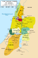
Català: Mapa dels territoris assignats a les "dotze tribus d'Israel" segons el Llibre de Josuè, capítols 13-19, abans del moviment de Dan al nord. Tingueu en compte que aquests territoris només estaven suposadament assignats a aquestes tribus, i els mateixos textos indiquen que les tribus tenien problemes per conquerir totes aquestes zones i ciutats als pobles nadius. El relat bíblic també pot estar lluny de ser històricament precís i ha estat discutit pels estudiosos. English: Map of the territories allotted to the "twelve tribes of Israel" according to the Book of Joshua, chapters 13–19, before the move of Dan to the North. Note that these territories were only allegedly allotted to said tribes, and the texts themselves indicate that the tribes had troubles conquering all these areas and cities from the native peoples. The Biblical account may also be far from historically accurate, and has been disputed by scholars. Nederlands: Kaart van de gebieden van de 12 stammen van Israël. Português: Mapa das 12 tribos de Israel Македонски: Карта на дванаесетте Израилеви племиња во Библијата, пред преселбата на Дановото племе на север Українська: 12 племен Ізраїля 中文(简体): 以色列十二支派地圖。 中文(繁體): 以色列十二支派地圖。 اردو : اسرائیل کے بارہ قبائل کا نقشہ العربية : خريطة للأراضي التي حُصصت لأسباط إسرائيل الاثني عشر حسب الإصحاحات 13-19 من كتاب يشوع قبل أن يتحرك دان نحو الشمال. النص الكتابي قد يكون غير دقيق تاريخياً أو يوجد خلاف حول دقته بين المختصين Syc: ܟܪܛܝܣܐ ܕܬܪܥܣܪ ܫܒ̈ܛܐ ܕܐܝܣܪܐܝܠ (ܩܕܡ ܫܢܐ ܫܒܛܐ ܕܕܢ ܠܓܪܒܝܐ) ܣܘܪܝܐܝܬ. |
||
| Origem |
|
||
| Autor | Original PNG by User:Janz, SVG Vectorização: User:יוסי, and translation of captions to Hebrew by he:משתמש:ברי"א and he:משתמש:דניאל צבי | ||
| Outras versões |
[editar]
|
||
| SVG desenvolvimento InfoField | O código-fonte desta imagem SVG é inválido devido a um erro. Esta carta geográfica inválida foi criada com o Inkscape. Esta carta geográfica SVG utiliza texto incorporado que pode ser facilmente traduzido usando um editor de texto. |


Licenciamento

|
É concedida permissão para copiar, distribuir e/ou modificar este documento nos termos da Licença de Documentação Livre GNU, versão 1.2 ou qualquer versão posterior publicada pela Free Software Foundation; sem Secções Invariantes, sem textos de Capa e sem textos de Contra-Capa. É incluída uma cópia da licença na secção intitulada GNU Free Documentation License.http://www.gnu.org/copyleft/fdl.htmlGFDLGNU Free Documentation Licensetruetrue |
| A utilização deste ficheiro é regulada nos termos da licença Creative Commons - Atribuição-CompartilhaIgual 3.0 Não Adaptada. | ||
| Atribuição: Janz | ||
| ||
| Esta marca de licenciamento foi adicionada a este ficheiro durante a atualização da licença GFDL.http://creativecommons.org/licenses/by-sa/3.0/CC BY-SA 3.0Creative Commons Attribution-Share Alike 3.0truetrue |
Legendas
Elementos retratados neste ficheiro
retrata
image/svg+xml
767e87491bd22c31ede66193b5943b22f37196bc
410 973 byte
3 300 pixel
2 168 pixel
Histórico do ficheiro
Clique uma data e hora para ver o ficheiro tal como ele se encontrava nessa altura.
| Data e hora | Miniatura | Dimensões | Utilizador | Comentário | |
|---|---|---|---|---|---|
| atual | 20h58min de 13 de novembro de 2007 | | 2 168 × 3 300 (401 kB) | יוסי | SVG version of Image:12 staemme israels.png done with Inkscape captions translation (to Hebrew) by he:משתמש:ברי"א and he:משתמש:דניאל צבי original license: {{GFDL-user-w|commons|commons|Janz}} [[Category:Maps of Anci |
Utilização local do ficheiro
Não há nenhuma página que use este ficheiro.
Utilização global do ficheiro
As seguintes wikis usam este ficheiro:
- he.wikipedia.org
- שבטי ישראל
- עשרת השבטים
- הר תבור
- שבט בנימין
- בנימין
- עבר הירדן
- שבט אשר
- שבט דן
- שבט יהודה
- יבוסים
- קעילה
- מקדה
- חשבון (עיר)
- שבט אפרים
- שבט נפתלי
- פרשת מטות
- שבט יששכר
- שבט גד
- שבט שמעון
- שבט זבולון
- שניים וחצי השבטים
- רמות גלעד
- סוכות (עבר הירדן)
- אדורים
- סקר הר מנשה
- דביר (עיר עתיקה)
- גשור (ממלכה)
- נחלת שבט דן
- נחלת שבט אפרים
- שבט ראובן
- נחלת שבט נפתלי
- נחלת שבט מנשה
- התנחלות השבטים
- עיר המלח
- רמה (שבט בנימין)
- רמה (מקרא)
- פרעתון
- מכמתת
- שבמה
- מולדה (אתר מקראי)
- בית המרכבות
- עין דור (אתר מקראי)
- אחלב
- עתר (אתר מקראי)
- בזק (אתר מקראי)
- אשתאול (אתר מקראי)
- בית פלט
- יהצה
- אלון בצעננים
- ארגוב (אתר מקראי)
Ver mais utilizações globais deste ficheiro.
Metadados
Este ficheiro contém informação adicional, provavelmente adicionada a partir da câmara digital ou scanner utilizada para criar ou digitalizar a imagem. Caso o ficheiro tenha sido modificado a partir do seu estado original, alguns detalhes poderão não refletir completamente as mudanças efetuadas.
| Largura | 2168 |
|---|---|
| Altura | 3300 |