Ficheiro:Bia-map-indian-reservations-usa.png
De Wikipedia, a enciclopédia encyclopedia
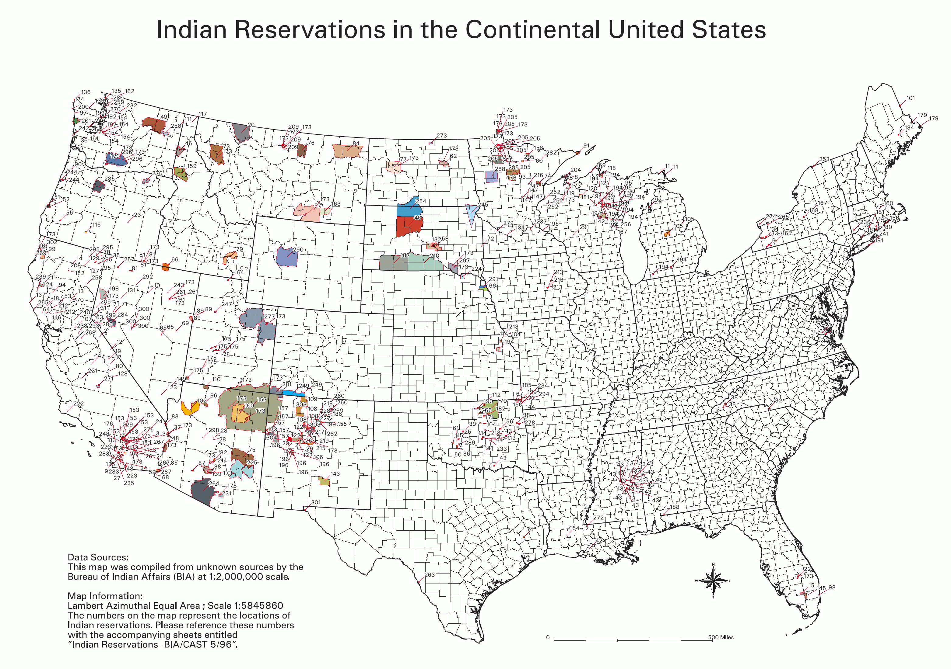
Imagem numa resolução maior (3 124 × 2 200 píxeis, tamanho: 457 kB, tipo MIME: image/png)
|
|
Esta imagem provém do Wikimedia Commons, um acervo de conteúdo livre da Wikimedia Foundation que pode ser utilizado por outros projetos.
|

|
Esta imagem de ethnographic map (ou todas as imagens neste artigo ou categoria) deveriam ser recriadas usando gráficos vectoriais, como ficheiros SVG. Isto tem várias vantagens; veja as Commons:Media for cleanup|imagens para rever para mais informações. Se já criou um ficheiro SVG desta imagem, por favor, carregue-o. Depois do novo ficheiro SVG ter sido carregado, substitua aqui esta predefinição pela predefinição {{vector version available|nome da nova imagem.svg}}.
|

|
Este ficheiro foi suplantado por File:Indian reservations in the Continental United States.png. Recomenda-se que o outro ficheiro seja utilizado. Nota: Este ficheiro não será apagado, até que seja explicitamente designado para apagar. Motivo: Updated to include newly-established reservations
|

|
Índice
Source
- National Park Service; see also: Bureau of Indian Affairs
Key
- 0 No Data
- Absentee Shawnee
- Acoma
- Agua Caliente
- Alabama-Coushatta
- Alabama-Quassarte Creeks
- Allegany
- Apache
- Bad River
- Barona Ranch
- Battle Mountain
- Bay Mills
- Benton Paiute
- Berry Creek
- Big Bend
- Big Cypress
- Big Lagoon
- Big Pine
- Big Valley
- Bishop
- Blackfeet
- Bridgeport
- Brighton
- Burns Paiute Colony
- Cabezon
- Caddo
- Cahuilla
- Campo
- Camp Verde
- Canoncito
- Capitan Grande
- Carson
- Catawba
- Cattaraugus
- Cayuga
- Cedarville
- Chehalis
- Chemehuevi
- Cherokee
- Cheyenne-Arapahoe
- Cheyenne River
- Chickasaw
- Chitimacha
- Choctaw
- Citizen Band Of Potawatomi
- Cochiti
- Coeur D'alene
- Cold Springs
- Colorado River
- Colville
- Comanche
- Coos, Lower Umpqua & Siuslaw
- Coquille
- Cortina
- Coushatta
- Cow Creek
- Creek
- Crow
- Crow Creek
- Cuyapaipe
- Deer Creek
- Delaware
- Devils Lake
- Dresslerville Colony
- Dry Creek
- Duckwater
- Duck Valley
- Eastern Shawnee
- East Cocopah
- Ely Colony
- Enterprise
- Fallon/Stillwater
- Flandreau Indian School
- Flathead
- Fond Du Lac
- Fort Apache
- Fort Belknap
- Fort Berthold
- Fort Bidwell
- Fort Hall
- Fort Independence
- Fort Mcdermitt
- Fort Mcdowell
- Fort Mohave
- Fort Peck
- Fort Yuma
- Ft. Sill Apache
- Gila Bend
- Gila River
- Goshute
- Grande Ronde
- Grand Portage
- Grand Traverse
- Greater Leech Lake
- Grindstone
- Hannahville
- Havasupai
- Hoh
- Hollywood
- Hoopa Valley
- Hopi
- Houlton Maliseets
- Hualapai
- Inaja
- Iowa
- Isabella
- Isleta
- Jackson
- Jemez
- Jicarilla
- Kaibab
- Kalispel
- Kaw
- Kialegee Creek
- Kickapoo
- Kiowa
- Klamath
- Kootenai
- L'anse
- Lac Courte Oreilles
- Lac Du Flambeau
- Lac Vieux Desert
- Laguna
- Las Vegas
- Laytonville
- La Jolla
- La Posta
- Likely
- Lone Pine
- Lookout
- Los Coyotes
- Lovelock Colony
- Lower Brule
- Lower Elwah
- Lower Sioux
- Lummi
- Makah
- Manchester
- Manzanita
- Maricopa
- Mashantucket Pequot
- Mattaponi
- Menominee
- Mescalero
- Miami
- Miccosukee
- Middletown
- Mille Lacs
- Mission
- Moapa
- Modoc
- Mole Lake
- Montgomery Creek
- Morongo
- Muckleshoot
- Nambe
- Narragansett
- Navajo
- Nett Lake
- Nez Perce
- Nipmuc-Hassanamisco
- Nisqually
- Nooksack
- Northern Cheyenne
- Northwestern Shoshone
- Oil Springs
- Omaha
- Oneida
- Onondaga
- Ontonagon
- Osage
- Otoe-Missouri
- Ottawa
- Out
- Ozette
- Paiute
- Pala
- Pamunkey
- Pascua Yaqui
- Passamaquoddy
- Paucatauk Pequot
- Paugusett
- Pawnee
- Pechanga
- Penobscot
- Peoria
- Picuris
- Pine Ridge
- Poarch Creek
- Pojoaque
- Ponca
- Poosepatuck
- Port Gamble
- Port Madison
- Potawatomi
- Prairie Isle
- Puertocito
- Puyallup
- Pyramid Lake
- Quapaw
- Quillayute
- Quinault
- Ramah
- Ramona
- Red Cliff
- Red Lake
- Reno-Sparks
- Rincon
- Roaring Creek
- Rocky Boys
- Rosebud
- Round Valley
- Rumsey
- Sac And Fox
- Salt River
- Sandia
- Sandy Lake
- Santa Ana
- Santa Clara
- Santa Domingo
- Santa Rosa
- Santa Rosa (North)
- Santa Ynez
- Santa Ysabel
- Santee
- San Carlos
- San Felipe
- San Ildefonso
- San Juan
- San Manual
- San Pasqual
- San Xavier
- Sauk Suiattle
- Seminole
- Seneca-Cayuga
- Sequan
- Shagticoke
- Shakopee
- Sheep Ranch
- Sherwood Valley
- Shingle Spring
- Shinnecock
- Shoalwater
- Shoshone
- Siletz
- Sisseton
- Skokomish
- Skull Valley
- Soboba
- Southern Ute
- Spokane
- Squaxon Island
- St. Croix
- St. Regis
- Standing Rock
- Stewarts Point
- Stockbridge Munsee
- Summit Lake
- Susanville
- Swinomish
- Taos
- Te-Moak
- Tesuque
- Texas Kickapoo
- Tohono O'odham
- Tonawanda
- Tonikawa
- Torres Martinez
- Toulumne
- Trindad
- Tulalip
- Tule River
- Tunica-Biloxi
- Turtle Mountains
- Tuscarora
- Twentynine Palms
- Umatilla
- Uintah And Ouray
- United Keetoowah Band Of Cherokee
- Upper Sioux
- Upper Skagit
- Ute Mountain
- Vermilion Lake
- Viejas
- Walker River
- Warm Springs
- Washoe
- West Cocopah
- White Earth
- Wichita
- Wind River
- Winnebago
- Winnemucca
- Woodford Indian Community
- Wyandotte
- Xl Ranch
- Yakama
- Yankton
- Yavapai
- Yerington
- Yomba
- Ysleta Del Sur
- Yurok
- Zia
- Zuni
Info contained in image
Data Sources: This map was compiled from unknown sources by the Bureau of Indian Affairs (BIA) at 1:2,000,000 scale.
Map Information: Lambert Azimuthal Equal Area; Scale 1:5845860 The numbers on the map represent the locations of Indian reservations. Please reference these numbers with the accompanying sheets entitled Indian Reservations - BIA/CAST 5/96
Descrição do ficheiro
Licenciamento
| Public domainPublic domainfalsefalse |
| Esta imagem ou ficheiro multimédia tem conteúdo baseado numa obra de um empregado do Serviço Nacional de Parques dos EUA, criada no âmbito dos deveres oficiais dessa pessoa. Por ser uma obra do governo federal dos EUA, ela está no domínio público nos Estados Unidos. Para mais informações, consulte NPS website e NPS copyright policy. |
derivative works
Obras derivadas deste ficheiro:
Legendas
Elementos retratados neste ficheiro
retrata
image/png
4bbf9ff352889a4d233ac05a68df95b1fe97c30f
467 634 byte
2 200 pixel
3 124 pixel
Histórico do ficheiro
Clique uma data e hora para ver o ficheiro tal como ele se encontrava nessa altura.
| Data e hora | Miniatura | Dimensões | Utilizador | Comentário | |
|---|---|---|---|---|---|
| atual | 01h06min de 1 de fevereiro de 2006 | | 3 124 × 2 200 (457 kB) | Wille Raab~commonswiki | BIA map of Indian Reservations in the Continental United States. An index to the reservations of the map can be found on the National NAGPRA site, http://www.cr.nps.gov/nagpra/. |
Utilização local do ficheiro
As seguintes 2 páginas usam este ficheiro:
Utilização global do ficheiro
As seguintes wikis usam este ficheiro:
- af.wikipedia.org
- ast.wikipedia.org
- bar.wikipedia.org
- ba.wikipedia.org
- be.wikipedia.org
- bg.wikipedia.org
- ca.wikipedia.org
- da.wikipedia.org
- de.wikipedia.org
- de.wikiversity.org
- en.wikipedia.org
- eo.wikipedia.org
- es.wikipedia.org
- eu.wikipedia.org
- fa.wikipedia.org
- fi.wikipedia.org
- frr.wikipedia.org
- fr.wikipedia.org
- fy.wikipedia.org
- gl.wikipedia.org
- he.wikipedia.org
- hi.wikipedia.org
- hu.wikipedia.org
- id.wikipedia.org
- it.wikipedia.org
Ver mais utilizações globais deste ficheiro.