فائل:RegionsHungary.png
From Wikipedia, the free encyclopedia
اس توں وڈی مورت موجود نہیں۔
RegionsHungary.png (۷۶۰ × ۵۰۰ پکسلز, فائل حجم: ۱۲۲ کلوبائٹ, MIME type: image/png)
ایہ فائل Wikimedia Commons توں اے تے دوجیاں ویونتاں تے وی ورتی جاسکدی اے۔ گل بات اس دے فائل گل بات صفحہ تے تھلے دتی گئی۔

|
This locator map image could be re-created using vector graphics as an SVG file. This has several advantages; see Commons:Media for cleanup for more information. If an SVG form of this image is available, please upload it and afterwards replace this template with
{{vector version available|new image name}}.
It is recommended to name the SVG file “RegionsHungary.svg”—then the template Vector version available (or Vva) does not need the new image name parameter. |
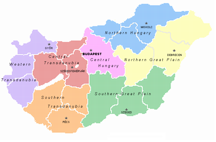
A map of the seven statistical regions of Hungary with their regional centres. It was made by User:Alensha by modifying the maps of the counties that also can be found here. If it means that the copyright is mine then I release it to public domain but if it belongs to the guy who made the pic Zalamegye.png from which it was modified, then it is GNU FDL.

|
کاپی کرن، ونڈن تے بدلن دی ایس ڈوکومنٹ لئی اجازت دتی جاندی اے ایہناں GNU Free Documentation License, Version 1.2 شرطاں نال یا مگروں کسے وی چھپے ورین Free Software Foundation توں بنا کسے انویرینٹ سیکشن دے، ناں فرنٹ کور لکھت تے ناں بیک کور لکھت دے۔ لسنس دی اک کاپی سیکشن وچ ہیگی اے جہدا ناں اے GNU Free Documentation License۔http://www.gnu.org/copyleft/fdl.htmlGFDLGNU Free Documentation Licensetruetrue |
| ایس فائل نوں کریٹو کامنز Attribution 2.5 پولینڈ لائسنس دتا گیا. | ||
| ||
| اس لائسنس دا ٹیگ GFDL دے مطابق اس فائل چ پایا گیا اے licensing update۔http://creativecommons.org/licenses/by-sa/3.0/CC BY-SA 3.0Creative Commons Attribution-Share Alike 3.0truetrue |
Captions
Add a one-line explanation of what this file represents
Items portrayed in this file
چترن
copyright status English
copyrighted English
فائل دی تریخ
فائل نو اس ویلے دی حالت وچ ویکھن واسطے تاریخ/ویلے تے کلک کرو۔
| تریخ تے ویلہ | نکی مورت | پاسے | ورتن والا | تیپّݨی کرو | |
|---|---|---|---|---|---|
| موجودہ | ۱۸:۰۹, ۲ مارچ ۲۰۰۷ | | ۷۶۰ × ۵۰۰ (۱۲۲ کلوبائٹ) | Tene~commonswiki | Optimised (5) |
| ۱۹:۰۷, ۲۱ مئی ۲۰۰۵ |  | ۷۶۰ × ۵۰۰ (۱۶۴ کلوبائٹ) | Alensha | A map of the seven statistical regions of Hungary with their regional centres. It was made by User:Alensha by modifying the maps of the counties that also can be found here. If it means that the copyright is mine then I release it to public domain but |
فائل دی ورتوں
تھلے دتے گئے 1 صفحے اس فائل نال جُڑدے نیں
فائل ویاپک ورتوں
ایہہ دوجے وکیاں ایس فائل نوں ورتدے نیں –
- ast.wikipedia.org تے ورتوں
- az.wikipedia.org تے ورتوں
- be.wikipedia.org تے ورتوں
- bs.wikipedia.org تے ورتوں
- ca.wikipedia.org تے ورتوں
- da.wikipedia.org تے ورتوں
- de.wikipedia.org تے ورتوں
- el.wikipedia.org تے ورتوں
- en.wikipedia.org تے ورتوں
- es.wikipedia.org تے ورتوں
- fa.wikipedia.org تے ورتوں
- fr.wikipedia.org تے ورتوں
- gl.wikipedia.org تے ورتوں
- he.wikipedia.org تے ورتوں
- hr.wikipedia.org تے ورتوں
- kk.wikipedia.org تے ورتوں
- lt.wikipedia.org تے ورتوں
- mt.wikipedia.org تے ورتوں
- nl.wikipedia.org تے ورتوں
ایس فائل دا ویکھو ہور جگت ورتن .