فائل:Deutschland_topo.jpg
From Wikipedia, the free encyclopedia
اصل فائل (۲,۰۱۱ × ۲,۶۵۴ پکسلز, فائل حجم: ۱.۷۶ میگابائٹ, MIME type: image/jpeg)
ایہ فائل Wikimedia Commons توں اے تے دوجیاں ویونتاں تے وی ورتی جاسکدی اے۔ گل بات اس دے فائل گل بات صفحہ تے تھلے دتی گئی۔
| تفصیلDeutschland topo.jpg |
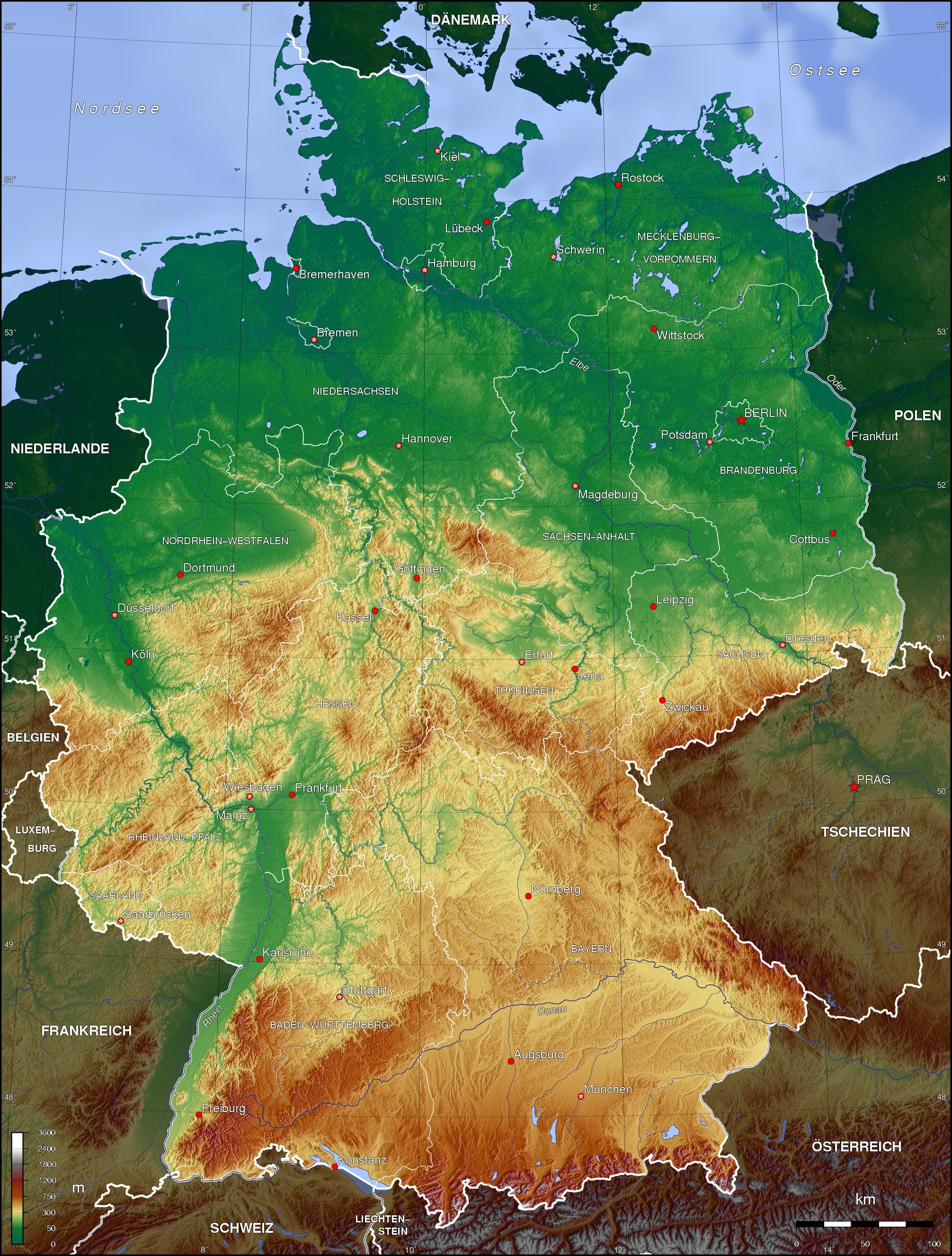
English: Topographic map of Germany (Borders of the States of Germany approximately as of 1990) Deutsch: Topografische Karte Deutschlands (Verlauf der Ländergrenzen etwa Stand 1990) |
| تریخ | |
| سروت | آپݨا کم |
| لکھاری | Botaurus-stellaris |
The map has been created with the Generic Mapping Tools: https://www.generic-mapping-tools.org/ using one or more of these public-domain datasets for the relief:
বাংলা ∙ English ∙ español ∙ français ∙ italiano ∙ 日本語 ∙ македонски ∙ sicilianu ∙ 中文(简体) ∙ 中文(繁體) ∙ +/− |

|
کاپی کرن، ونڈن تے بدلن دی ایس ڈوکومنٹ لئی اجازت دتی جاندی اے ایہناں GNU Free Documentation License, Version 1.2 شرطاں نال یا مگروں کسے وی چھپے ورین Free Software Foundation توں بنا کسے انویرینٹ سیکشن دے، ناں فرنٹ کور لکھت تے ناں بیک کور لکھت دے۔ لسنس دی اک کاپی سیکشن وچ ہیگی اے جہدا ناں اے GNU Free Documentation License۔http://www.gnu.org/copyleft/fdl.htmlGFDLGNU Free Documentation Licensetruetrue |
| ایس فائل نوں کریٹو کامنز Attribution 2.5 پولینڈ لائسنس دتا گیا. | ||
| ||
| اس لائسنس دا ٹیگ GFDL دے مطابق اس فائل چ پایا گیا اے licensing update۔http://creativecommons.org/licenses/by-sa/3.0/CC BY-SA 3.0Creative Commons Attribution-Share Alike 3.0truetrue |
derivative works
Derivative works of this file: Deutschland topo cropped.jpg
Captions
Items portrayed in this file
چترن
creator English
some value
copyright status English
copyrighted English
۱۷ نومبر 2006
source of file English
original creation by uploader English
media type English
image/jpeg
فائل دی تریخ
فائل نو اس ویلے دی حالت وچ ویکھن واسطے تاریخ/ویلے تے کلک کرو۔
| تریخ تے ویلہ | نکی مورت | پاسے | ورتن والا | تیپّݨی کرو | |
|---|---|---|---|---|---|
| موجودہ | ۰۴:۴۳, ۱۷ نومبر ۲۰۰۶ | | ۲,۰۱۱ × ۲,۶۵۴ (۱.۷۶ میگابائٹ) | Botaurus-stellaris |
فائل دی ورتوں
تھلے دتے گئے 3 صفحے اس فائل نال جُڑدے نیں
فائل ویاپک ورتوں
ایہہ دوجے وکیاں ایس فائل نوں ورتدے نیں –
- af.wikipedia.org تے ورتوں
- als.wikipedia.org تے ورتوں
- ar.wikipedia.org تے ورتوں
- ast.wikipedia.org تے ورتوں
- azb.wikipedia.org تے ورتوں
- az.wikipedia.org تے ورتوں
- bar.wikipedia.org تے ورتوں
- be-tarask.wikipedia.org تے ورتوں
- be.wikipedia.org تے ورتوں
- bn.wikipedia.org تے ورتوں
- bo.wikipedia.org تے ورتوں
- bs.wikipedia.org تے ورتوں
- bxr.wikipedia.org تے ورتوں
- ce.wikipedia.org تے ورتوں
- ckb.wikipedia.org تے ورتوں
- cs.wikipedia.org تے ورتوں
- da.wikipedia.org تے ورتوں
- de.wikipedia.org تے ورتوں
- Karte (Kartografie)
- Benutzer:Nainoa
- Benutzer:Meisel
- Benutzer:Kiezkicker
- Bucht
- Wikipedia:WikiProjekt Kommunen und Landkreise in Deutschland
- Benutzer:Meph666/Galerie
- Benutzer:Metrics
- Benutzer:Kuellmann.de
- Benutzer:Paulimausi
- Benutzer:RMeier
- Wikipedia:Kandidaten für exzellente Bilder/Archiv2005/10
- Benutzer:Dr Nibbles
- Benutzer:Tjö
- Geographie Deutschlands
- Benutzer:Neurowiki
- Benutzer:MyChaOS
- Benutzer:Behrev
- Benutzer:Stefan Zwierlein
ایس فائل دا ویکھو ہور جگت ورتن .
میٹا ڈیٹا
اس فائل وچ ہور وی معلومات نے، شاید او ڈیجیٹل کیمرے یا سکینر نے پائیاں گئیاں نے جس نال اینو کچھیا یا ڈیجیٹل بنایا گیا اے۔
اگر فائل نو ایدی اصلی حالت توں تبدیل کیتا گیا اے تے کجھ تفصیلات تبدیل ہوئی فائل دے بارے چ نئیں دسن گیاں۔
| _error | ۰ |
|---|