File:ElectoralCollege2000-Large.png
From Wikipedia, the free encyclopedia
ଏହି ଦେଖଣାର ଆକାର: ୮୦୦ × ୪୩୦ ପିକ୍ସେଲ । ବାକି ରେଜୋଲୁସନ: ୩୨୦ × ୧୭୨ ପିକ୍ସେଲ | ୬୪୦ × ୩୪୪ ପିକ୍ସେଲ | ୧,୧୮୨ × ୬୩୫ ପିକ୍ସେଲ.
ମୂଳ ଫାଇଲ (୧,୧୮୨ × ୬୩୫ ପିକସେଲ, ଫାଇଲ ଆକାର: ୧୭୫ KB, ଏମ.ଆଇ.ଏମ.ଇର ପ୍ରକାର: image/png)
This is a file from the Wikimedia Commons. Information from its description page there is shown below. |
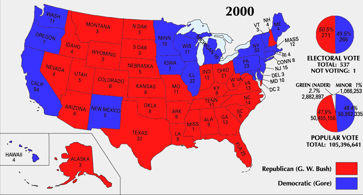
| U.S. presidential election maps from the National Atlas of the United States |
| See also: SVG maps |
| 1789 · 1792 · 1796 · 1800 · 1804 · 1808 · 1812 · 1816 · 1820 · 1824 · 1828 · 1832 · 1836 · 1840 · 1844 · 1848 · 1852 · 1856 · 1860 · 1864 · 1868 · 1872 · 1876 · 1880 · 1884 · 1888 · 1892 · 1896 · 1900 · 1904 · 1908 · 1912 · 1916 · 1920 · 1924 · 1928 · 1932 · 1936 · 1940 · 1944 · 1948 · 1952 · 1956 · 1960 · 1964 · 1968 · 1972 · 1976 · 1980 · 1984 · 1988 · 1992 · 1996 · 2000 · 2004 |
ସାରକଥା


ସତ୍ଵ
| Public domainPublic domainfalsefalse |
This map was obtained from an edition of the National Atlas of the United States. Like almost all works of the U.S. federal government, works from the National Atlas are in the public domain in the United States.
Online access: NationalAtlas.gov | 1970 print edition: Library of Congress, Perry-Castañeda Library čeština | Deutsch | English | français | Bahasa Indonesia | italiano | македонски | മലയാളം | sicilianu | 中文 | 中文(简体) | 中文(繁體) | +/− |
ଫାଇଲ ଇତିହାସ
ଏହା ଫାଇଲଟି ସେତେବେଳେ ଯେମିତି ଦିଶୁଥିଲା ତାହା ଦେଖିବା ପାଇଁ ତାରିଖ/ବେଳା ଉପରେ କ୍ଲିକ କରନ୍ତୁ
| ତାରିଖ/ବେଳ | ନଖ ଦେଖଣା | ଆକାର | ବ୍ୟବହାରକାରୀ | ମତାମତ | |
|---|---|---|---|---|---|
| ଏବେକାର | ୦୫:୨୧, ୨୬ ଜୁନ ୨୦୦୮ | | ୧,୧୮୨ × ୬୩୫ (୧୭୫ KB) | Tallicfan20 | better resolution |
| ୦୬:୩୨, ୧୪ ଫେବୃଆରୀ ୨୦୦୮ |  | ୧,୧୮୨ × ୬୩୫ (୮୩ KB) | SteveSims~commonswiki | Reverted to version as of 10:23, 25 July 2007. The version with Nader as green didn't look very good. | |
| ୦୩:୩୮, ୮ ଫେବୃଆରୀ ୨୦୦୮ |  | ୧,୧୮୨ × ୬୩୫ (୨.୧୫ MB) | SteveSims~commonswiki | Ralph Nader's popular votes made green. Also public domain. | |
| ୧୫:୫୩, ୨୫ ଜୁଲାଇ ୨୦୦୭ |  | ୧,୧୮୨ × ୬୩୫ (୮୩ KB) | Cardsplayer4life~commonswiki | Reverted to earlier revision | |
| ୧୫:୧୬, ୨୫ ଜୁଲାଇ ୨୦୦୭ |  | ୧,୧୮୨ × ୬୩୫ (୬୨ KB) | Joseph Solis in Australia~commonswiki | {{PD-USGov-Atlas}} Category:2000 {{US presidential election maps}} | |
| ୦୮:୦୦, ୨ ଜୁଲାଇ ୨୦୦୭ |  | ୧,୧୮୨ × ୬୩୫ (୮୩ KB) | Cardsplayer4life~commonswiki | {{PD-USGov-Atlas}} Source: EN Wiki {{US presidential election maps}} | |
| ୧୫:୩୮, ୨୯ ଜୁନ ୨୦୦୭ |  | ୧,୧୮୨ × ୬୩୫ (୬୨ KB) | Joseph Solis in Australia~commonswiki | {{PD-USGov-Atlas}} Category:2000 {{US presidential election maps}} | |
| ୦୨:୩୪, ୨୨ ଜୁନ ୨୦୦୭ |  | ୧,୧୮୨ × ୬୩୫ (୮୩ KB) | Cardsplayer4life~commonswiki | {{PD-USGov-Atlas}} Category:2000 {{US presidential election maps}} | |
| ୧୫:୫୧, ୧୯ ଅଗଷ୍ଟ ୨୦୦୫ |  | ୧,୧୮୨ × ୬୩୫ (୬୨ KB) | Ondrejk | {{PD-USGov-Atlas}} Source: EN Wiki |
ଫାଇଲ ବ୍ୟବହାର
ଏହି ଫାଇଲ ସହିତ ଯୋଡ଼ା ଗୋଟିଏ ବି ପୃଷ୍ଠା ନାହିଁ ।
ଜଗତ ଫାଇଲ ବ୍ୟବହାର
ତଳଲିଖିତ ଉଇକିସବୁ ଏହି ଫାଇଲଟିକୁ ବ୍ୟବହାର କରିଥାନ୍ତି:
- el.wikipedia.orgରେ ବ୍ୟବହାର
- en.wikipedia.orgରେ ବ୍ୟବହାର
- fa.wikipedia.orgରେ ବ୍ୟବହାର
- sv.wikipedia.orgରେ ବ୍ୟବହାର
- uk.wikipedia.orgରେ ବ୍ୟବହାର