File:Czechoslovakia_I.png
From Wikipedia, the free encyclopedia
Talha d'aquesta previsualizacion: 800 × 364 pixèls. Autras resolucions : 320 × 146 pixèls | 640 × 291 pixèls | 1 128 × 513 pixèls.
Fichièr d'origina (1 128 × 513 pixèl, talha del fichièr: 66 Ko, tipe MIME: image/png)
| Aqueste fichièr proven de Wikimedia Commons?. Las informacions que lo concernisson son afichadas çaijós (procedura). |
| DescripcionCzechoslovakia I.png |
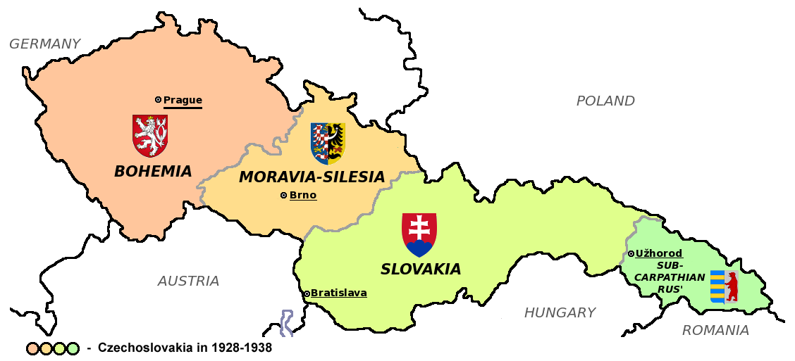
Čeština: Zemská mapa Československa v letech 1928 až 1938 s vyznačenými zemskými hlavními městy a znaky jednotlivých zemí English: Maps of Czechoslovakia in 1928-1938 with marked borders of all four Czechoslovak countries and their coats of arms and regional capital cities
Based on Image:Czechoslovakia_COA_medium.svg. * |
| Data | (UTC) |
| Font | |
| Autor | |
| Autras versions |
Derivative works of this file: |
| Això és una imatge retocada, cosa que vol dir que ha estat alterada digitalment de la seva versió original. Modificacions: Simplified map. L'original es pot veure a: CarpathianRutheniaCoA.svg:
|
Aqueste fichièr es jos licéncia Creative Commons licéncia generica atribucion-partiment a l'identic 3.0
- Sètz liure :
- de partejar – de copiar, distribuir e transmetre aquesta òbra
- d'adaptar – d'adaptar aquesta òbra
- Jos las condicions seguentas :
- atribucion – Vos cal atribuir aquesta òbra amb lo biais especificat per l'autor o lo concedent (mas pas dins un sens que suggerís que vos apròvan o qu'apròvan l'utilizacion d'aquesta òbra).
- partiment a l'identic – Se modificatz, transformatz, o vos basatz sus aquesta òbra, vos cal distribuir l'òbra resultanta jos la meteissa licéncia o una licéncia similara a aquesta.
Registre original de càrregues
This image is a derivative work of the following images:
- File:Czechoslovakia01.png licensed with PD-self
- 2011-05-19T10:54:48Z PANONIAN 1128x513 (64020 Bytes) minor change, marked provincial capitals
- 2011-05-17T09:53:27Z PANONIAN 1128x513 (63994 Bytes) Reverted to version as of 10:38, 24 April 2011 - because this is map of Czechoslovakia and it was capital of Czechoslovakia
- 2011-05-17T05:07:38Z Millenium187 1128x513 (56086 Bytes) Why was Prague underlined and Vienna, Brno, Bratislava and other capital cities were not? -- corrected
- 2011-04-24T10:38:30Z PANONIAN 1128x513 (63994 Bytes) few corrections
- 2011-04-23T11:31:49Z PANONIAN 1128x509 (62348 Bytes) improved version
- 2008-12-20T20:58:14Z Kirk 1100x497 (80038 Bytes) {{Information |Description= |Source= |Date= |Author= |Permission= |other_versions= }}
- 2006-12-28T16:11:35Z Electionworld 1100x497 (92110 Bytes) {{ew|en|PANONIAN}} Map of {{link|Czechoslovakia}} (self made) Note: The provinces shown on the map were introduced by Act No. 125/1927 Zb. and became effective in 1928. {{PD-self}} [[Category:Maps of Czechoslovakia]] [[Cat
- File:Small_coat_of_arms_of_the_Czech_Republic2.png licensed with PD-self
- 2006-07-18T15:34:18Z Poznaniak 486x594 (126651 Bytes) {{Information |Description=Godło Czech |Source=własna praca |Date=18.07.2006 |Author=[[:user:Poznaniak|Poznaniak]] |Permission= }}
- File:Moravia-Silesia.png licensed with PD-self
- 2010-07-25T21:44:29Z RgC 490x600 (65918 Bytes) {{Information |Description={{en|1=Joint of coat of arms of Moravia and Silesia.}} |Source={{own}} |Author=[[User:RgC|RgC]] |Date=2010-07-25 |Permission= |other_versions= }} [[Category:User page images]]
- File:Coat_of_arms_of_Slovakia.svg licensed with Cc-by-sa-3.0-migrated, GFDL
- 2006-06-06T21:41:47Z Tlusťa 400x500 (4623 Bytes) ==Summary== {{Information |Description={{en|Coat of arms of the [[Slovakia]].}} {{cs|Znak [[:cs:Slovensko|Slovenska]].}} |Source= |Date= |Author=[[User:Tlusťa|Tlusťa]] |Permission= |other_versions= }} ==Licensing == {{GFDL
- File:CarpathianRutheniaCoA.svg licensed with Cc-pd-mark-footer, PD-old
- 2007-06-01T16:53:20Z DDima 325x394 (27235 Bytes) fix colors
- 2006-11-08T06:35:05Z Happenstance 325x394 (27214 Bytes) created
Téléversé avec derivativeFX
| Annotations InfoField | This image is annotated: View the annotations at Commons |
426
165
76
76
1128
513
Wrong coat of arms (violation of WP:NOR) – Moravian-Silesian Province had CoA composed of double shield, placed side by side (one with Moravian and one with Silesian eagle)
Llegendes
Afegeix una explicació d'una línia del que representa aquest fitxer
Elements representats en aquest fitxer
subjècte representat
estatus dels drets d'autor catalan
amb drets d'autor catalan
12 agost 2011
tipus de mèdia d'Internet catalan
image/png
suma de verificació catalan
196c82b4bea76f59cd4e74d855e6f7b5162451a4
mida de les dades catalan
67 684 Byte
513 píxel
amplada catalan
1 128 píxel
Istoric del fichièr
Clicar sus una data e una ora per veire lo fichièr tal coma èra a aqueste moment
| Data e ora | Miniatura | Dimensions | Utilizaire | Comentari | |
|---|---|---|---|---|---|
| actual | 12 agost de 2011 a 18.40 | | 1 128×513 (66 Ko) | Millenium187 | {{Information |Description={{cs|Zemská mapa Československa v letech 1928 až 1938 s vyznačenými zemskými hlavními městy a znaky jednotlivých zemí}} {{en|Maps of Czechoslovakia in 1928-1938 with marked borders of all four Czechoslovak countries a |
Paginas que contenon lo fichièr
I a ges de pagina que compòrta un ligam vèrs aqueste imatge.
Usatge global del fichièr
Los autres wikis seguents utilizan aqueste imatge :
- Utilizacion sus azb.wikipedia.org
- Utilizacion sus az.wikipedia.org
- Utilizacion sus bn.wikipedia.org
- Utilizacion sus da.wikipedia.org
- Utilizacion sus de.wikipedia.org
- Utilizacion sus el.wikipedia.org
- Utilizacion sus en.wikipedia.org
- Utilizacion sus es.wikipedia.org
- Utilizacion sus he.wikipedia.org
- Utilizacion sus io.wikipedia.org
- Utilizacion sus mk.wikipedia.org
- Utilizacion sus sq.wikipedia.org
- Utilizacion sus te.wikipedia.org
- Utilizacion sus th.wikipedia.org
- Utilizacion sus tr.wikipedia.org
- Utilizacion sus uk.wikipedia.org
Recuperada de « https://oc.wikipedia.org/wiki/Fichièr:Czechoslovakia_I.png »