File:ElectoralCollege1980-Large.png
From Wikipedia, the free encyclopedia
Størrelse på denne forhåndsvisningen: 800 × 430 piksler. Andre oppløsninger: 320 × 172 piksler | 640 × 344 piksler | 1 182 × 635 piksler.
Opprinnelig fil (1 182 × 635 piksler, filstørrelse: 166 KB, MIME-type: image/png)
| Denne filen er fra Wikimedia Commons og kan brukes av andre prosjekter. Informasjonen fra filbeskrivelsessiden vises nedenfor. |
| U.S. presidential election maps from the National Atlas of the United States |
| See also: SVG maps |
| 1789 · 1792 · 1796 · 1800 · 1804 · 1808 · 1812 · 1816 · 1820 · 1824 · 1828 · 1832 · 1836 · 1840 · 1844 · 1848 · 1852 · 1856 · 1860 · 1864 · 1868 · 1872 · 1876 · 1880 · 1884 · 1888 · 1892 · 1896 · 1900 · 1904 · 1908 · 1912 · 1916 · 1920 · 1924 · 1928 · 1932 · 1936 · 1940 · 1944 · 1948 · 1952 · 1956 · 1960 · 1964 · 1968 · 1972 · 1976 · 1980 · 1984 · 1988 · 1992 · 1996 · 2000 · 2004 |
Beskrivelse
| BeskrivelseElectoralCollege1980-Large.png |
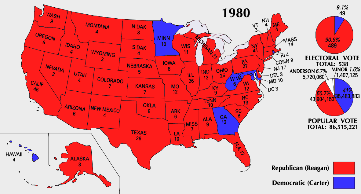
English: 1980 Electoral College Map |
| Kilde | https://nationalmap.gov/small_scale/printable/elections.html |
| Opphavsperson | Amerikas forente staters geologiske undersøkelse |

|
Dette bildet bør gjenskapes med hjelp av vektorgrafikk som en SVG-fil. Dette har flere fordeler, se Commons:Media for cleanup for mer informasjon. Hvis en SVG-fil med dette bildet er tilgjengelig, vennligst last den opp. Etter opplasting erstatt denne malen med {{vector version available|nytt bilde.svg}}.
|
Lisensiering
| Public domainPublic domainfalsefalse |
This map was obtained from an edition of the National Atlas of the United States. Like almost all works of the U.S. federal government, works from the National Atlas are in the public domain in the United States.
Online access: NationalAtlas.gov | 1970 print edition: Library of Congress, Perry-Castañeda Library čeština | Deutsch | English | français | Bahasa Indonesia | italiano | македонски | മലയാളം | sicilianu | 中文 | 中文(简体) | 中文(繁體) | +/− |
Filhistorikk
Klikk på et tidspunkt for å vise filen slik den var på det tidspunktet.
| Dato/klokkeslett | Miniatyrbilde | Dimensjoner | Bruker | Kommentar | |
|---|---|---|---|---|---|
| nåværende | 25. jul. 2007 kl. 12:18 | | 1 182 × 635 (166 KB) | Cardsplayer4life~commonswiki | Reverted to earlier revision |
| 25. jul. 2007 kl. 11:34 |  | 1 182 × 635 (107 KB) | Joseph Solis in Australia~commonswiki | {{PD-USGov-Atlas}} Category:1980 {{US presidential election maps}} | |
| 9. jul. 2007 kl. 03:44 |  | 1 182 × 635 (166 KB) | Cardsplayer4life~commonswiki | {{PD-USGov-Atlas}} {{US presidential election maps}} | |
| 6. jul. 2007 kl. 11:38 |  | 1 182 × 635 (107 KB) | Joseph Solis in Australia~commonswiki | {{PD-USGov-Atlas}} Category:1980 {{US presidential election maps}} | |
| 2. jul. 2007 kl. 04:28 |  | 1 182 × 635 (166 KB) | Cardsplayer4life~commonswiki | {{PD-USGov-Atlas}} {{US presidential election maps}} | |
| 29. jun. 2007 kl. 12:16 |  | 1 182 × 635 (107 KB) | Joseph Solis in Australia~commonswiki | {{PD-USGov-Atlas}} Category:1980 {{US presidential election maps}} | |
| 21. jun. 2007 kl. 23:07 |  | 1 182 × 635 (166 KB) | Cardsplayer4life~commonswiki | {{PD-USGov-Atlas}} Category:1980 {{US presidential election maps}} | |
| 31. mai 2007 kl. 10:31 |  | 1 182 × 635 (107 KB) | Joseph Solis in Australia~commonswiki | {{PD-USGov-Atlas}} {{US presidential election maps}} | |
| 25. mai 2006 kl. 22:05 |  | 1 182 × 635 (94 KB) | JP06035 | switched colors | |
| 22. jan. 2006 kl. 18:08 |  | 1 182 × 635 (107 KB) | Red devil 666 | {{PD-USGov-Atlas}} |
Filbruk
Det er ingen sider som bruker denne filen.
Global filbruk
Følgende andre wikier bruker denne filen:
- Bruk i cs.wikipedia.org
- Bruk i da.wikipedia.org
- Bruk i en.wikipedia.org
- Bruk i fi.wikipedia.org
- Bruk i fr.wikipedia.org
- Bruk i hu.wikipedia.org
- Bruk i it.wikipedia.org
- Bruk i nl.wikipedia.org
- Bruk i uk.wikipedia.org
- Bruk i vi.wikipedia.org
Metadata
Denne filen inneholder tilleggsinformasjon, sannsynligvis lagt til av digitalkameraet eller skanneren som ble brukt til å lage eller digitalisere det.
Hvis filen har blitt forandret fra utgangspunktet, kan enkelte detaljer være unøyaktige.
| Horisontal oppløsning | 28,35 dpc |
|---|---|
| Vertikal oppløsning | 28,35 dpc |