Fil:Beaver_wars_map.jpg
From Wikipedia, the free encyclopedia
Opprinnelig fil (871 × 736 piksler, filstørrelse: 163 KB, MIME-type: image/jpeg)
| Denne filen er fra Wikimedia Commons og kan brukes av andre prosjekter. Informasjonen fra filbeskrivelsessiden vises nedenfor. |
| BeskrivelseBeaver wars map.jpg |
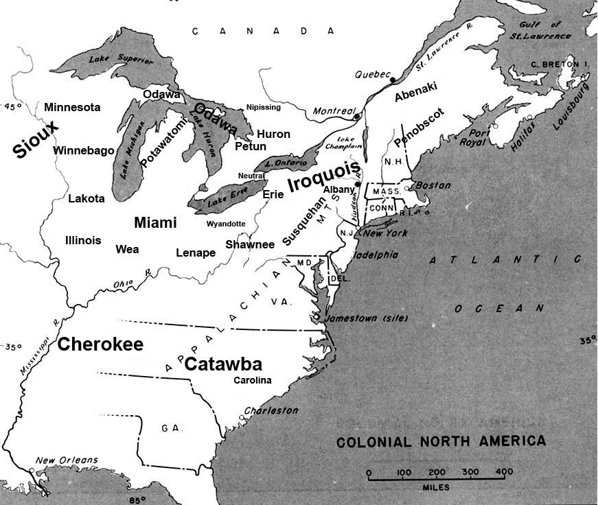
English: Map of the location of major tribes involved in the Beaver Wars laid against a period map showing colonial settlments |
|||
| Dato | ||||
| Kilde | Eget verk | |||
| Opphavsperson | Charles Edward | |||
| Tillatelse (Gjenbruk av denne filen) |
|
Info
This represents the approximate configuration of the tribes in 1648. Although the areas are large, the populations were low and large parts of the territories where uninhabited, and instead used as hunting grounds. The tribes were also semi nomadic, and the period was rife with war and several of the tribes on the map were destroyed in the 1650s. The map was made using information in several books incluing:
- Jennings, Francis (1984) The Ambiguous Iroquois Empire ISBN: 0393017192.
- Wallace, Paula W (2007) Indians in Pennsylvania, DIANE Publishing Inc ISBN: 1422314936.
Bildetekster
Elementer som er med i denne fila
motiv
En verdi uten element på Wikidata
image/jpeg
eea8e663c82e0a23525be04d55ebe0491c41e211
167 366 byte
736 piksel
871 piksel
Filhistorikk
Klikk på et tidspunkt for å vise filen slik den var på det tidspunktet.
| Dato/klokkeslett | Miniatyrbilde | Dimensjoner | Bruker | Kommentar | |
|---|---|---|---|---|---|
| nåværende | 19. nov. 2008 kl. 00:34 | | 871 × 736 (163 KB) | Charles Edward | Slight adjustment to name on image |
| 19. nov. 2008 kl. 00:33 |  | 871 × 736 (164 KB) | Charles Edward | {{Information |Description=adjustment of locations per discussion on Beaver War talk page |Source= |Date= |Author= |Permission= |other_versions= }} | |
| 16. nov. 2008 kl. 21:51 |  | 871 × 736 (298 KB) | Charles Edward | {{Information |Description=New version removes borders, ads more ambiguity to the map |Source= |Date= |Author= |Permission= |other_versions= }} | |
| 16. nov. 2008 kl. 04:43 |  | 815 × 472 (275 KB) | Charles Edward | {{Information |Description= |Source= |Date= |Author= |Permission= |other_versions= }} | |
| 16. nov. 2008 kl. 03:16 |  | 815 × 472 (275 KB) | Charles Edward | {{Information |Description=adding tribes, adjusting locations |Source= |Date= |Author= |Permission= |other_versions= }} Category:Maps of the United States | |
| 16. nov. 2008 kl. 02:39 |  | 815 × 472 (270 KB) | Charles Edward | {{Information |Description=Added additional tribes |Source= |Date= |Author= |Permission= |other_versions= }} | |
| 16. nov. 2008 kl. 02:35 |  | 815 × 472 (270 KB) | Charles Edward | {{Information |Description=Added additional tribes |Source= |Date= |Author= |Permission= |other_versions= }} | |
| 16. nov. 2008 kl. 02:14 |  | 815 × 472 (262 KB) | Charles Edward | {{Information |Description={{en|1=Map of the location of major tribes involved in the Beaver Wars laid against a period map showing colonial settlments}} |Source=Own work by uploader |Author=Charles Edward |Date=11-15-8 |Permission |
Filbruk
Den følgende siden bruker denne filen:
Global filbruk
Følgende andre wikier bruker denne filen:
- Bruk i azb.wikipedia.org
- Bruk i cs.wikipedia.org
- Bruk i en.wikipedia.org
- Bruk i es.wikipedia.org
- Bruk i et.wikipedia.org
- Bruk i gl.wikipedia.org
- Bruk i id.wikipedia.org
- Bruk i it.wikipedia.org
- Bruk i ja.wikipedia.org
- Bruk i lv.wikipedia.org
- Bruk i nl.wikipedia.org
- Bruk i pl.wikipedia.org
Metadata
Denne filen inneholder tilleggsinformasjon, sannsynligvis lagt til av digitalkameraet eller skanneren som ble brukt til å lage eller digitalisere det.
Hvis filen har blitt forandret fra utgangspunktet, kan enkelte detaljer være unøyaktige.
| Retning | Normal |
|---|---|
| Horisontal oppløsning | 200 dpi |
| Vertikal oppløsning | 200 dpi |
| Programvare brukt | Adobe Photoshop CS2 Windows |
| Dato og tid for filendring | 18. nov. 2008 kl. 17:29 |
| Fargerom | Ukalibrert |