File:East-Hem_565ad.jpg
From Wikipedia, the free encyclopedia
Opphavleg fil (3 240 × 1 903 pikslar, filstorleik: 773 KB, MIME-type: image/jpeg)
Denne fila er frå Wikimedia Commons og kan verta nytta av andre prosjekt. Skildringa frå filskildringssida der er vist nedanfor.
Følgjande er henta frå filomtalen åt denne fila på Wikimedia Commons:

|
Dette historical map biletet bør verta oppretta på nytt som vektorgrafikk i SVG-format. Dette har fleire føremoner; sjå Commons:Media for cleanup for meir informasjon. Om ein SVG-versjon av dette biletet alt er tilgjengeleg, gjer vel og last han opp. Ettar å ha lasta opp ei SVG-fil, erstatt denne malen med {{vector version available|nytt biletnamn.svg}}.
|
 | Dette bildet er lastet opp i JPEG-format selv om det ikke inneholder fotografisk informasjon. Denne informasjonen kan lagres mer effektivt eller nøyaktig i PNG- eller SVG-format. Dersom det er mulig, vennligst last opp en PNG- eller SVG-versjon av dette bildet uten komprimeringsfeil, basert på en annen kilde enn JPEG (eller der eksisterende feil er fjernet). Etter dette, vennligst merk JPEG-versjonen med {{Superseded|NyttBilde.filendelse}} og fjern denne malen. Denne malen bør ikke settes på fotografier eller skannede bilder. Dersom dette bildet er et diagram eller annet bilde egnet for vektorisering, vennligst merk dette bildet med {{Convert to SVG}} i stedet for {{BadJPEG}}. Dersom det ikke er egnet for vektorisering, bruk {{Convert to PNG}}. For mer informasjon, se {{BadJPEG}}. |  |
| SkildringEast-Hem 565ad.jpg |
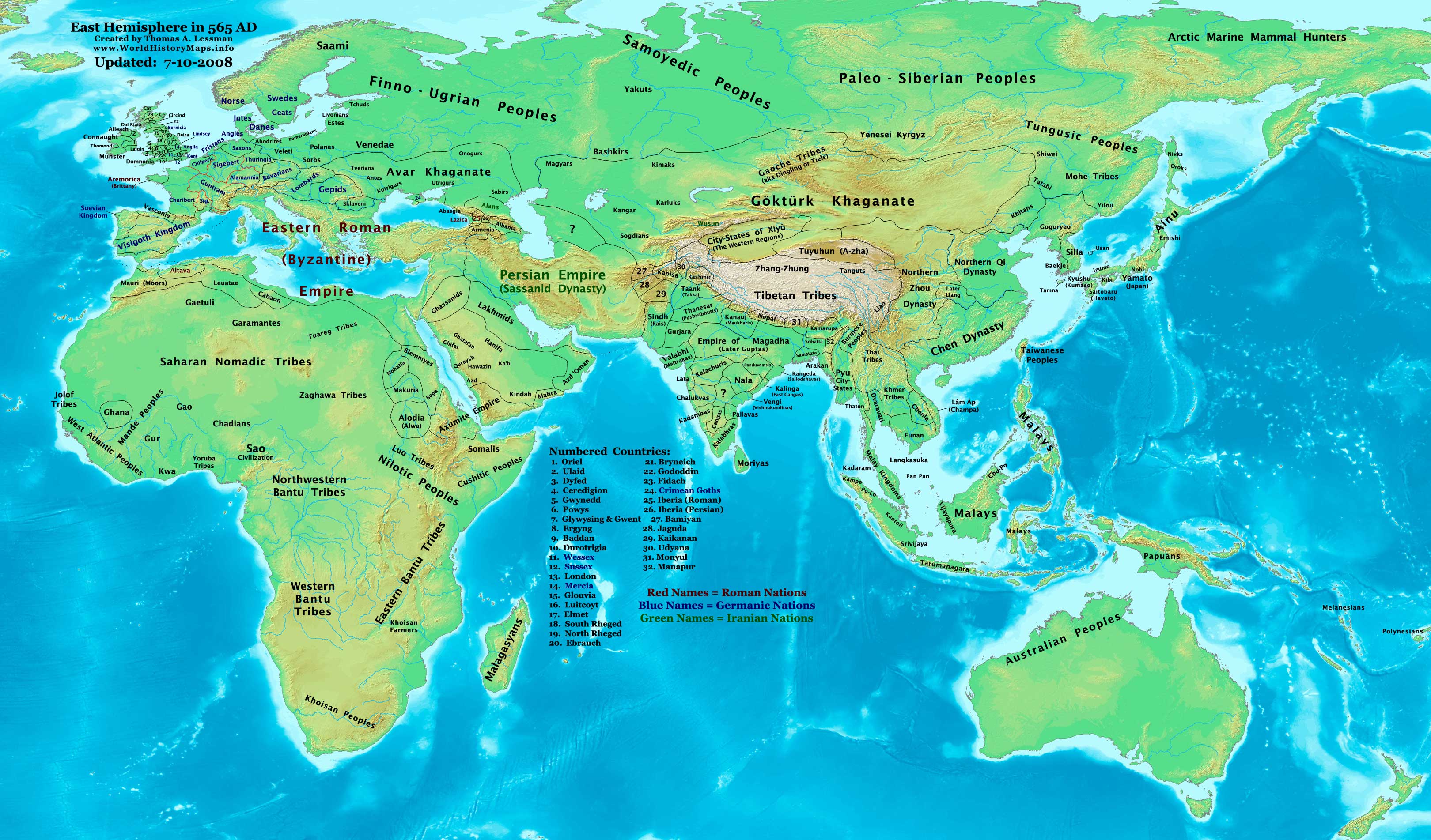
English: Eastern Hemisphere in 565 AD |
| Kjelde | self-made (For reference information, see the Map Source References section below.) |
| Opphavsperson | Thomas Lessman (Contact!) |
| Løyve (Gjenbruk av denne fila) |
Eg, opphavsrettshaldaren til verket, publiserer det hermed under denne lisensen: Denne fila er lisensiert under lisensen Creative Commons Namngjeving-DelPåSameVilkåra 3.0 Unported
|
| Andre versjonar |
Derivative works of this file: see East-Hem_565ad.jpg file history on Wikipedia. |
Map Summary
Original Source URL: http://www.thomaslessman.com/History/images/East-Hem_565ad.jpg.
This map of the Eastern Hemisphere in 565 AD was created by Thomas Lessman, based on information from the sources listed below. This map is free for educational use (see Permission info above). When using this map, please mention that it is available for free at www.WorldHistoryMaps.info.
Map Source References
- Remember, sources often conflict with each other. This map is only as accurate as the information that is available to me. To report any errors or to help further this work, please click here, or email Thomas Lessman at talessman@yis.us
References for information contained in this map:
Primary Sources for East-Hem_565ad.jpg:
- 1. The DK Atlas of World History, 2000 Edition; map of The World in 500 CE, (Pages 50-51) (See other specific references below)
- 2. John Nelson. Map of the "Countries of the World 1/1/565 CE." Interactive Historical Atlas of the World since 500BCE. World History Maps Inc., Alexandria, VA, 2008. Available at www.WorldHistoryMaps.com.
- 3. The History & Commercial Atlas of China, maps of The Divisions of China, 530 & 560 AD and Asia in 610 AD, available at Huhai.net
- 4. Wikimedia's World Map 500 CE, made by User:Javierfv1212, and Wikipedia articles (noted below).
I - African Information
Note: Most of my African Information comes from The DK Atlas of World History map of The Development of Complex Societies in Africa; (Pg 160).
- (Bantus, Berber Tribes, Chadians, Cushites, Daamat, Garamantes, Gur, Khoisan Peoples, Kwa, Libyans, Mandes, Nilotic Peoples, West Atlantic Peoples)
- Nubian/Sudanese borders (Makuria, Nobatia, Alodia, Blemmyes, Bega, Axum, etc.) are derived from these sources:
- 1. The DK Atlas of World History map of "Northeast Africa, c. 500 CE"; (Pg. 161)
- 2. Denis Bellemare. Historical Atlas of Late Antiquity. Map of Arabia in 540 AD
- Ghana's location is derived from John Nelson's map of the "Countries of the World, 1-1-500 CE", available at www.WorldHistoryMaps.com.
- North African borders are derived from a comparison of
- 1. Denis Bellemare. Historical Atlas of Late Antiquity. Comparison of the maps of North Africa in 540 AD and North Africa in 580 AD.
II - Asian Information
- Arabian borders & Tribal locations are derived from a combination of these sources:
- 1. The MidEastWeb.org map of Arabia in 500 CE.
- 2. Denis Bellemare. Historical Atlas of Late Antiquity. Maps of "Southern Arabia in 540 AD and North Arabia in 540 AD.
- 3. Wikipedia's map of Pre-Islamic Arab tribal locations, created by User:Slackerlawstudent.
Note: I used information in various Wikipedia articles to reconcile the maps and the borders I depict for Arabia.
- Chinese Borders are derived from the History & Commercial Atlas of China, map of The Divisions of China, 530 & 560 AD, available on Huhai.net
- India's borders are derived from these sources:
- 1. John Nelson. Map of the "Countries of the World 1/1/565 CE." Interactive Historical Atlas of the World since 500BCE. World History Maps Inc., Alexandria, VA, 2008. Available at www.WorldHistoryMaps.com.
- 2. The Historical Atlas of South Asia, maps of "The Gupta-Vakataka Age, c. A.D. 300-500" and "The age of Pusyabhuti and Calukyan ascendancy, c. A.D. 550-700", by Joseph Schwartzberg.
- Japanese information is derived from The DK Atlas of World History map of "State Formation in Korea & Japan to 650 CE"; (Pg 264)
III - European Information
Note: Borders of Europe are mostly derived from a combination of:
1. The www.Euratlas.com map of Europe in 600 AD and to a lesser extent, their map of Europe in 500 AD.
- (Please note: User:Bogomolov.PL has done a great job of showing me possible discrepancies in my north European borders compared to this source, due to the differences in the geographical layout of the maps.)
2. John Nelson. Map of the "Countries of the World 1/1/565 CE." Interactive Historical Atlas of the World since 500BCE. World History Maps Inc., Alexandria, VA, 2008. Available at www.WorldHistoryMaps.com.
- British/English Borders derived from "Early British Kingdoms" map of Britain in 550 AD and their map of Britain in 575 AD.
4. Fringe areas like Africa, Australia, Siberia, etc. are partially derived from Wikimedia's map of The world in 500 CE, created by User:Javierfv1212.
5. Much of the information in this map was cross-checked with Bruce Gordon's Regnal Chronologies.
Other Maps by Thomas Lessman
| Maps of the eastern hemisphere showing history
Bold dates are available on Wikimedia or Wikipedia. | ||
| Primeval | ||
| Ancient
|
·| 600 BC | 550 BC | 527 BC | 500 BC |
400 BC | ·| 1 AD | 50 AD | 100 AD | 200 AD | 300 AD | | |
| Medieval |
·| 500 AD | 565 AD | 600 AD | 700 AD | | |
| Modern |
·| 1500 AD | · * For historical maps of the whole world, | |
| history links talk edit view | ||
Bilettekstar
Element som er med i denne fila
motiv
Verdi utan eit element på Wikidata
CC BY-SA 3.0 Unported norsk bokmål
Filhistorikk
Klikk på dato/klokkeslett for å sjå fila slik ho var på det tidspunktet.
| Dato/klokkeslett | Miniatyrbilete | Oppløysing | Brukar | Kommentar | |
|---|---|---|---|---|---|
| gjeldande | 11. juli 2008 kl. 00:29 | | 3 240 × 1 903 (773 KB) | Talessman | |
| 9. mai 2008 kl. 23:18 |  | 3 240 × 1 903 (760 KB) | Talessman | {{Information |Description=Eastern Hemisphere in 565 AD. |Source=self-made |Author=Thomas Lessman |Permission={{self|cc-by-sa-3.0}} }} |
Filbruk
Det finst ikkje noka side som bruker denne fila.
Global filbruk
Desse andre wikiane nyttar fila:
- Bruk på azb.wikipedia.org
- Bruk på bar.wikipedia.org
- Bruk på be.wikipedia.org
- Bruk på br.wikipedia.org
- Bruk på de.wikipedia.org
- Bruk på el.wikipedia.org
- Bruk på en.wikipedia.org
- Bruk på es.wikipedia.org
- Bruk på fa.wikipedia.org
- Bruk på fr.wikipedia.org
- Bruk på hr.wikipedia.org
- Bruk på hy.wikipedia.org
- Bruk på ka.wikipedia.org
- Bruk på mn.wikipedia.org
- Bruk på no.wikipedia.org
- Bruk på pt.wikipedia.org
- Bruk på rue.wikipedia.org
- Bruk på ru.wikipedia.org
- Bruk på sh.wikipedia.org
- Bruk på sl.wikipedia.org
- Bruk på sv.wikipedia.org
- Bruk på tr.wikipedia.org
- Bruk på uk.wikipedia.org
- Bruk på vi.wikipedia.org
Utvida informasjon
Fila inneheld tilleggsopplysningar, mest sannsynleg frå digitalkameraet eller skannaren som vart brukt til å lage eller digitalisere henne.
Dersom fila har vore endra sidan ho vart oppretta, kan nokre av opplysningane vere feil.
| _error | 0 |
|---|