Gouchaupre is een plaats en voormalige gemeente in het Franse departement Seine-Maritime in de regio Normandië en telt 165 inwoners (2004). De plaats maakt deel uit van het arrondissement Dieppe.
| Plaats in Frankrijk | |||
|---|---|---|---|
| Situering | |||
| Regio | Normandië | ||
| Departement | Seine-Maritime (76) | ||
| Arrondissement | Dieppe | ||
| Kanton | Envermeu | ||
| Gemeente | Petit-Caux | ||
| Coördinaten | 49° 56′ NB, 1° 18′ OL | ||
| Algemeen | |||
| Oppervlakte | 4,4 km² | ||
| Inwoners (2004) |
165 (37,5 inw./km²) | ||
| Hoogte | 126 - 154 m | ||
| Overig | |||
| Postcode(s) | 76630 | ||
| INSEE-code | 76310 | ||
| Foto's | |||
 | |||
| De kerk van Gouchaupre | |||
| |||
Geschiedenis
Gouchaupre is op 1 januari 2016 gefuseerd met de gemeenten Assigny, Auquemesnil, Belleville-sur-Mer, Berneval-le-Grand, Biville-sur-Mer, Bracquemont, Brunville, Derchigny, Glicourt, Greny, Guilmécourt, Intraville, Penly, Saint-Martin-en-Campagne, Saint-Quentin-au-Bosc, Tocqueville-sur-Eu en Tourville-la-Chapelle tot de commune nouvelle Petit-Caux.
Geografie
De oppervlakte van Gouchaupre bedraagt 4,4 km², de bevolkingsdichtheid is 37,5 inwoners per km².
De onderstaande kaart toont de ligging van Gouchaupre met de belangrijkste infrastructuur en aangrenzende gemeenten.
 |
Demografie
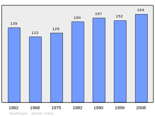
Onderstaande figuur toont het verloop van het inwonertal (bron: INSEE-tellingen).

Externe links
Wikiwand in your browser!
Seamless Wikipedia browsing. On steroids.
Every time you click a link to Wikipedia, Wiktionary or Wikiquote in your browser's search results, it will show the modern Wikiwand interface.
Wikiwand extension is a five stars, simple, with minimum permission required to keep your browsing private, safe and transparent.

