File:Majak_Satellitenkarte.jpg
Uit Wikipedia, de vrije encyclopedia
Grootte van deze voorvertoning: 800 × 509 pixels. Andere resoluties: 320 × 204 pixels | 640 × 408 pixels | 1.024 × 652 pixels | 1.448 × 922 pixels.
Oorspronkelijk bestand (1.448 × 922 pixels, bestandsgrootte: 292 kB, MIME-type: image/jpeg)
Dit is een bestand van Wikimedia Commons.
Onderstaande beschrijving komt van de beschrijving van het bestand daar.
Onderstaande beschrijving komt van de beschrijving van het bestand daar.
| BeschrijvingMajak Satellitenkarte.jpg |
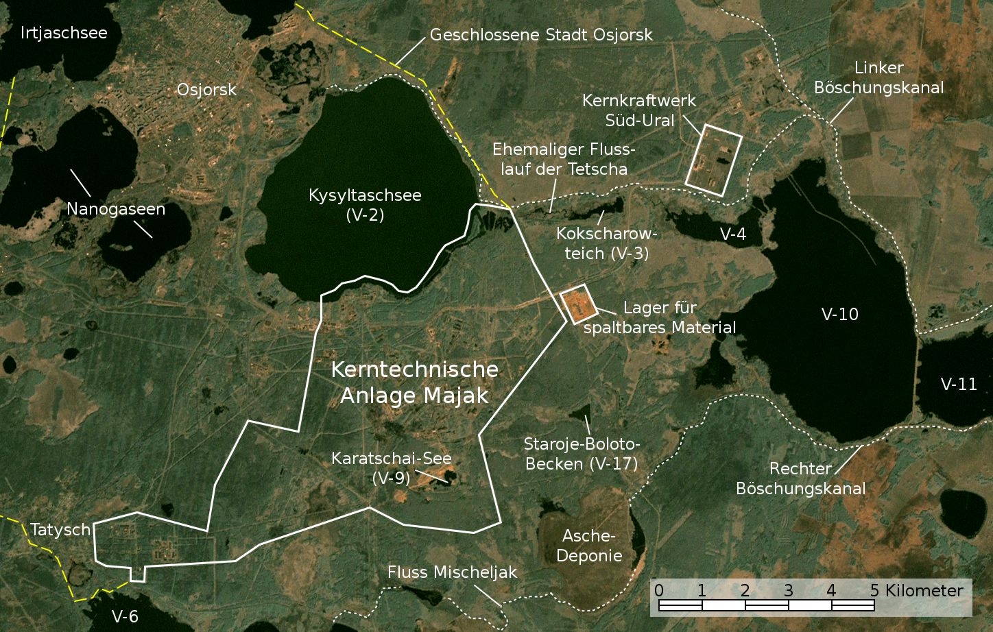
English: Satellite image/map of the Mayak nuclear facility, the closed town of Ozyorsk/Ozersk (Chelyabinsk-65), different lakes and reservoirs, and the South Urals nuclear power plant.
Based on a screenshot from NASA World Wind (Landsat Global Mosaic visual layer), color corrected.
Deutsch: Satellitenfoto/Karte der kerntechnischen Anlage Majak, der geschlossenen Stadt Osjorsk (Tscheljabinsk-65), verschiedenen Seen und Reservoire sowie dem Kernkraftwerk Süd-Ural.
Basierend auf einem Screenshot aus NASA World Wind (Landsat Global Mosaic visual layer), farbkorrigiert. |
|||||||
| Datum | ||||||||
| Bron | NASA World Wind screenshot (Landsat Global Mosaic visual layer) | |||||||
| Auteur | NASA, Jan Rieke (color correction, borders and labels) | |||||||
| Toestemming (Hergebruik van dit bestand) |
|
|||||||
| Andere versies | File:Satellite image map of Mayak.jpg |

| Dit is een geretoucheerde foto, wat betekent dat de originele versie digitaal aangepast is. Aanpassingen: Farbkorrektur, Bezeichnungen und Grenzen. Aanpassingen gedaan door JanRieke.
|
| Cameralocatie | 55° 42′ 58,57″ NB, 60° 49′ 54,34″ OL | Deze en andere afbeeldingen in: OpenStreetMap |
|---|
Nennung der Urheber bei Weiterverwendung außerhalb der Wikipedia wäre schön, ist aber nicht erforderlich.
Quellen
Hauptquellen
- Igor Kudrik, Aleksandr Nikitin, Charles Digges, Nils Bøhmer, Vladislav Larin, Vladimir Kuznetsov: The Russian Nuclear Industry – The Need for Reform. Bellona Report Volume 4:2004. Bellona Foundation, S. 47–69, 1. November 2004
- Map of the system of dams and drainage channels at Mayak., in: AMAP Assessment Report: Arctic Pollution Issues, Arctic Monitoring & Assessment Programme, Working Group of the Arctic Council, 1998
- Dmitriy Burmistrov, Mira Kossenko, Richard Wilson: Radioactive Contamination of the Techa River and its Effects. archief kopie op de Wayback Machine Technology, Vol. 7, S. 553-575, 2000
Weitere Quellen
Position von V-6
- B. Gusakov, A. Demin, M. Zawadzki, V. Kalinkin, A. Kirsanov, N. Shafrova: Решение экологических проблем Теченского каскада водоемов на ПО "Маяк"., 19. Dezember 2006
Aschedeponie
- A. R. Hutter: Radioactive contamination distribution in the bottom sediments and water of the Mishelyak River[dead link], Journal of Radioanalytical and Nuclear Chemistry, 2001
- O. Aleksandrova: Natural remediation of surface water systems used as deposits of nuclear industry waste by humic substances, Dissertation, Universität Osnabrück, 2009
| Aantekeningen InfoField | Deze afbeelding is aangetekend: Bekijk de aantekeningen op Commons |
Bijschriften
Beschrijf in één regel wat dit bestand voorstelt
Image satellite de l'installation nucléaire de Mayak, de la ville fermée d'Ozyorsk/Ozersk (Chelyabinsk-65), de différents lacs et réservoirs et de la centrale nucléaire du sud de l'Oural.
Items getoond in dit bestand
beeldt af
14 mei 2010
55°42'58.57"N, 60°49'54.34"E
Bestandsgeschiedenis
Klik op een datum/tijd om het bestand te zien zoals het destijds was.
| Datum/tijd | Miniatuur | Afmetingen | Gebruiker | Opmerking | |
|---|---|---|---|---|---|
| huidige versie | 28 nov 2010 04:48 | | 1.448 × 922 (292 kB) | JanRieke | Yellow color for closed city borders, slightly reduced brightness |
| 14 nov 2010 02:53 |  | 1.448 × 922 (282 kB) | JanRieke | Included courses of rivers, minor other changes | |
| 15 mei 2010 01:09 |  | 1.448 × 922 (276 kB) | JanRieke | {{Information |Description={{en|1=Satellite image/map of the Mayak nuclear facility, the closed town of Ozyorsk/Ozersk (Chelyabinsk-65), different lakes and reservoirs, and the South Urals nuclear power plant. Based on a screenshot from NASA World Wind (L |
Bestandsgebruik
Geen enkele pagina gebruikt dit bestand.
Globaal bestandsgebruik
De volgende andere wiki's gebruiken dit bestand:
- Gebruikt op arz.wikipedia.org
- Gebruikt op ba.wikipedia.org
- Gebruikt op ceb.wikipedia.org
- Gebruikt op da.wikipedia.org
- Gebruikt op de.wikipedia.org
- Gebruikt op de.wikivoyage.org
- Gebruikt op es.wikipedia.org
- Gebruikt op fr.wikipedia.org
- Gebruikt op hu.wikipedia.org
- Gebruikt op ja.wikipedia.org
- Gebruikt op nn.wikipedia.org
- Gebruikt op ru.wikipedia.org
- Gebruikt op sr.wikipedia.org
- Gebruikt op uk.wikipedia.org
- Gebruikt op www.wikidata.org
Metadata
Dit bestand bevat metadata met EXIF-informatie, die door een fotocamera, scanner of fotobewerkingsprogramma toegevoegd kan zijn.
| _error | 0 |
|---|
Overgenomen van "https://nl.wikipedia.org/wiki/Bestand:Majak_Satellitenkarte.jpg"