
Earley
plaats in Berkshire / Uit Wikipedia, de vrije encyclopedia
Earley (ook wel Erleigh en Erlegh) is een civil parish in het Engelse graafschap Berkshire. De stad ligt in het district Wokingham en telt 30.868 inwoners.
 St Peter
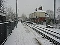 Station


Aldermaston · Aldworth · Arborfield and Newland · Ashampstead · Barkham · Basildon · Beech Hill · Beedon · Beenham · Binfield · Bisham · Boxford · Bracknell · Bradfield · Bray · Brightwalton · Brimpton · Britwell · Bucklebury · Burghfield · Catmore · Chaddleworth · Charvil · Chieveley · Cold Ash · Colnbrook with Poyle · Combe · Compton · Cookham · Cox Green · Crowthorne · Datchet · Earley · East Garston · East Ilsley · Enborne · Englefield · Eton · Farnborough · Fawley · Finchampstead · Frilsham · Great Shefford · Greenham · Hampstead Norreys · Hamstead Marshall · Hermitage · Holybrook · Horton · Hungerford · Hurley · Inkpen · Kintbury · Lambourn · Leckhampstead · Midgham · Mortimer Common · Newbury · Old Windsor · Padworth · Pangbourne · Peasemore · Purley on Thames · Remenham · Ruscombe · Sandhurst · Shaw-cum-Donnington · Shinfield · Shottesbrooke · Sonning · Speen · St. Nicholas Hurst · Stanford Dingley · Stratfield Mortimer · Streatley · Sulhamstead · Sunningdale · Sunninghill and Ascot · Swallowfield · Thatcham · Theale · Tidmarsh with Sulham · Tilehurst · Twyford · Ufton Nervet · Waltham St. Lawrence · Warfield · Wargrave · Wasing · Welford · West Ilsley · West Woodhay · Wexham Court · White Waltham · Winkfield · Winnersh · Winterbourne · Wokefield · Wokingham · Wokingham Without · Woodley · Woolhampton · Wraysbury · Yattendon
08-05-2008
| Civil parish in Engeland | |||
|---|---|---|---|
 | |||
| Situering | |||
| Regio | South East England | ||
| Graafschap | Berkshire | ||
| District | Wokingham | ||
| Coördinaten | 51° 26' NB, 0° 56' WL | ||
| Algemeen | |||
| Oppervlakte | 9,9320 km² | ||
| Inwoners (2011) |
30868 (3108 inw./km²) | ||
| Overig | |||
| Postcode(s) | RG6 | ||
| Netnummer(s) | 0118 | ||
| Grid code | SU7571 | ||
| Post town | READING | ||
| ONS-code | E04001230 | ||
| Website | Officiële website | ||
| Foto's | |||
 | |||
| Shepherd's Hill | |||
| |||