Bestand:MapaMacau1912.jpg
Uit Wikipedia, de vrije encyclopedia
Grootte van deze voorvertoning: 416 × 599 pixels. Andere resoluties: 167 × 240 pixels | 631 × 908 pixels.
Oorspronkelijk bestand (631 × 908 pixels, bestandsgrootte: 81 kB, MIME-type: image/jpeg)
Dit is een bestand van Wikimedia Commons.
Onderstaande beschrijving komt van de beschrijving van het bestand daar.
Onderstaande beschrijving komt van de beschrijving van het bestand daar.
Beschrijving
| BeschrijvingMapaMacau1912.jpg |
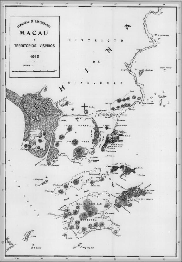
English: This is a map of Macau and is surrounded territories in 1912. In that time, the Portuguese Colony of Macau is formed by the Peninsula de Macau, Taipa and Coloane islands. Macau also have a great influence on the islands of Lapa, D. João and Montanha, located on the west of the Portuguese Colony of Macau. See here for original color version. |
| Datum | |
| Bron |
Dit bestand heeft geen gegevens over de bron.
Pas de bestandsbeschrijving aan en voeg de bron toe. |
| Auteur |
Dit bestand heeft geen gegevens over de auteur.
|
Licentie
| Public domainPublic domainfalsefalse |
This work is from an official work of Macau and is in the public domain in Macau and possibly other jurisdictions. See here for the type of material that are in the Public domain in Chinese and Portuguese (official languages of Macau), plus English (not an official language of Macau).
|
 | |
| English ∙ español ∙ 日本語 ∙ 한국어 ∙ македонски ∙ português ∙ português do Brasil ∙ ไทย ∙ 中文(简体) ∙ 中文(繁體) ∙ +/− |
| Aantekeningen InfoField | Deze afbeelding is aangetekend: Bekijk de aantekeningen op Commons |
314
361
29
23
631
908
Chin-san [Qianshan]
328
377
21
20
631
908
Casa Branca [Residence & office of the subprefect with jurisdiction over Macao]
Bijschriften
Beschrijf in één regel wat dit bestand voorstelt
Items getoond in dit bestand
beeldt af
Bestandsgeschiedenis
Klik op een datum/tijd om het bestand te zien zoals het destijds was.
| Datum/tijd | Miniatuur | Afmetingen | Gebruiker | Opmerking | |
|---|---|---|---|---|---|
| huidige versie | 14 feb 2007 11:34 | | 631 × 908 (81 kB) | AdriAg | This is a map of Macau and is surrounded territories in 1912. In that time, the Portuguese Colony of Macau is formed by the [http://pt.wikipedia.org/wiki/Pen%C3%ADnsula_de_Macau Peninsula de Macau], [http://pt.wikipedia.org/wiki/Taipa Taipa] and [http://p |
Bestandsgebruik
Dit bestand wordt op de volgende pagina gebruikt:
Globaal bestandsgebruik
De volgende andere wiki's gebruiken dit bestand:
- Gebruikt op en.wikipedia.org
- Gebruikt op es.wikipedia.org
- Gebruikt op fa.wikipedia.org
- Gebruikt op fr.wikipedia.org
- Gebruikt op it.wikipedia.org
- Gebruikt op ja.wikipedia.org
- Gebruikt op mwl.wikipedia.org
- Gebruikt op no.wikipedia.org
- Gebruikt op pt.wikipedia.org
- Gebruikt op ru.wikipedia.org
- Gebruikt op ur.wikipedia.org
- Gebruikt op zh.wikipedia.org
Metadata
Dit bestand bevat metadata met EXIF-informatie, die door een fotocamera, scanner of fotobewerkingsprogramma toegevoegd kan zijn.
| _error | 0 |
|---|
Overgenomen van "https://nl.wikipedia.org/wiki/Bestand:MapaMacau1912.jpg"