File:Great_Schism_1054_with_former_borders.png
From Wikipedia, the free encyclopedia
Saiz pralihat ini: 560 × 599 piksel. Leraian-leraian lain: 224 × 240 piksel | 448 × 480 piksel | 717 × 768 piksel | 957 × 1,024 piksel | 2,000 × 2,141 piksel.
Fail asli (2,000 × 2,141 piksel, saiz fail: 420 KB, jenis MIME: image/png)
Fail ini dari Wikimedia Commons dan mungkin digunakan oleh projek lain. Penerangan pada laman penerangan failnya di sana ditunjukkan di bawah.
| The factual accuracy of this map is disputed. See File talk:Great Schism 1054 with former borders.png#Numerous problems, map is unreliable. |

|
This religion map image could be re-created using vector graphics as an SVG file. This has several advantages; see Commons:Media for cleanup for more information. If an SVG form of this image is available, please upload it and afterwards replace this template with
{{vector version available|new image name}}.
It is recommended to name the SVG file “Great Schism 1054 with former borders.svg”—then the template Vector version available (or Vva) does not need the new image name parameter. |
Ringkasan
| KeteranganGreat Schism 1054 with former borders.png |
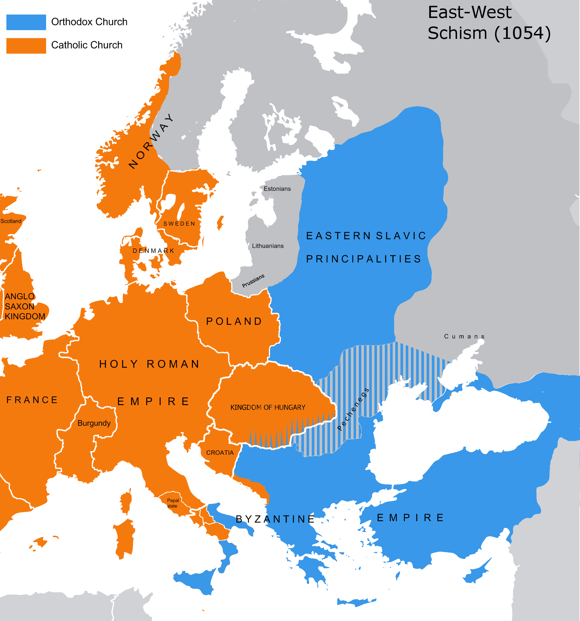
English: The map of the eastern/western allegiances in 1054 with the former country borders.
Español: El mapa de las creencias en el este/oeste en 1054 con las fronteras del país anterior. Los puntos representan concentraciones de minorías y no ubicaciones específicas. Las líneas rayadas representan cohabitaciones religiosas y no mayorías (que están representadas por colores sólidos).
Deutsch: Karte über das Morgenländische Schisma mit den ehemaligen Landesgrenzen. Die schraffierten Linien stellen religiöse Zusammenleben und keine Mehrheiten dar (die durch Vollfarben dargestellt werden).
Magyar: A nagy kelet-nyugati egyházszakadás térképe az 1054-nek megfelelő határokkal. A pontok a kisebbségek koncentrációját jelölik, nem pedig meghatározott helyeket. A sraffozott vonalak a vallási együttéléseket jelölik, nem pedig a többséget (amelyeket egyszínű színek jelölnek). |
|||
| Tarikh | 04.09.2010. | |||
| Sumber | Source: Westermanns Atlas zur Weltgeschichte, 1957, p. 64-5, maps titled "Staaten u. Bekenntnisse im Mittelmeerraum nach den ersten Kreuzzügen (um 1190)" (p. 64) and "Mittelmeerwelt und Vorderasien vor Beginn der Kreuzzüge (1096)" (p. 65) and Alexander Kazhdan (dir.), Oxford Dictionary of Byzantium, Oxford University Press, 1991, 1re éd., 3 tom. (ISBN 978-0-19-504652-6, LCCN 90023208), art. « Patriarchates », vol. 3, pp. 1599-1600. | |||
| Pengarang | Tobi85 | |||
| Kebenaran (Penggunaan semula fail ini) |
|
|||
| Versi lain | Derivative works of this file: Great Schism 1054 with former borders-ar.png |
Perlesenan
| Public domainPublic domainfalsefalse |
| Saya selaku pemegang hak cipta karya ini melepaskan karya ini ke dalam domain awam di seluruh dunia. Di sesetengah negara, undang-undangnya mungkin tidak mengizinkan; jika begitu: Saya memberi sesiapa sahaja hak untuk menggunakan karya ini untuk apa jua tujuan, tanpa sebarang syarat, melainkan undang-undang menetapkan syarat-syarat sedemikian. |
_en.png)
.png)
.jpg)
Captions
Add a one-line explanation of what this file represents
Items portrayed in this file
menggambarkan
media type Inggeris
image/png
Sejarah fail
Klik pada tarikh/waktu untuk melihat rupa fail tersebut pada waktu itu.
| Tarikh/Waktu | Gambar kenit | Ukuran | Pengguna | Komen | |
|---|---|---|---|---|---|
| semasa | 13:16, 9 Julai 2023 | | 2,000 × 2,141 (420 KB) | Veverve | Reverted to version as of 21:25, 11 November 2022 (UTC): this is a huge extrapolation to make based solely on the fact that there were some Byzantine churches in Hungary |
| 15:01, 19 Mac 2023 |  | 2,000 × 2,141 (439 KB) | Moodylo333 | Reverted to 8 November 2017 according with Dora Wiebenson, József Sisa, Pál Lövei, "The architecture of historic Hungary" (p. 11) who admit the presence of byzantine churches in Eastern Hungary. | |
| 21:25, 11 November 2022 |  | 2,000 × 2,141 (420 KB) | Gyalu22 | As Veverve said, no personal opinions should be used. The previous status in Hungary was drawn by Cepleanu who referred to the Westermanns Atlas in the talk page. But that atlas shows the situation very differently. | |
| 19:58, 23 Oktober 2022 |  | 2,000 × 2,141 (479 KB) | Veverve | Reverted to version as of 11:04, 1 June 2022 (UTC) original research and personnal opinions should no be used | |
| 19:12, 23 Oktober 2022 |  | 2,000 × 2,141 (492 KB) | Gyalu22 | Religion was not an ethnic question. Transylvania was a religiously diverse region, but Catholicism was already dominant to Alba Iulia | |
| 11:04, 1 Jun 2022 |  | 2,000 × 2,141 (479 KB) | Moodylo333 | Reliable version with Alexander Kazhdan (dir.), Oxford Dictionary of Byzantium, New York et Oxford, Oxford University Press, 1991, 1re éd., 3 tom. (ISBN 978-0-19-504652-6 et 0-19-504652-8, LCCN 90023208), 1991, art. « Patriarchates », vol. 3, pp. 1599-1600. | |
| 13:51, 1 Februari 2022 |  | 2,000 × 2,141 (488 KB) | Moodylo333 | Reverted to version as of 20:17, 8 July 2018 (UTC) without Bogomils (off topic) | |
| 13:49, 1 Februari 2022 |  | 2,000 × 2,141 (488 KB) | Moodylo333 | Reverted to version as of 20:15, 8 July 2018 (UTC) : COM:CROP | |
| 09:41, 26 November 2021 |  | 2,000 × 2,141 (420 KB) | Veverve | Reverted to version as of 15:53, 26 October 2011 (UTC) revert to version closer to the Westermanns Atlas zur Weltgeschichte, see File_talk:Great_Schism_1054_with_former_borders.png#Numerous_problems,_map_is_unreliable | |
| 23:18, 29 Mei 2021 |  | 2,000 × 2,141 (494 KB) | Ceha | Catholic-ortodox borders in the southeast |
Penggunaan fail
Tiada laman yang menggunakan fail ini.
Penggunaan fail sejagat
Fail ini digunakan oleh wiki-wiki lain yang berikut:
- Penggunaan di ar.wikipedia.org
- Penggunaan di ca.wikipedia.org
- Penggunaan di cs.wikipedia.org
- Penggunaan di de.wikipedia.org
- Penggunaan di de.wikibooks.org
- Penggunaan di en.wikipedia.org
- Penggunaan di fr.wikipedia.org
- Penggunaan di ga.wikipedia.org
- Penggunaan di hu.wikipedia.org
- Penggunaan di ro.wikipedia.org
- Penggunaan di www.wikidata.org
Metadata
Fail ini mengandungi maklumat tambahan daripada kamera digital atau pengimbas yang digunakan untuk menghasilkannya. Jika fail ini telah diubah suai daripada rupa asalnya, beberapa butiran dalam maklumat ini mungkin sudah tidak relevan.
| Leraian mengufuk | 28.35 dpc |
|---|---|
| Leraian menegak | 28.35 dpc |
Diambil daripada "https://ms.wikipedia.org/wiki/Fail:Great_Schism_1054_with_former_borders.png"