Файл:Verbreitungsgebiet_der_Tataren.PNG
From Wikipedia, the free encyclopedia
Үзлэгийн хэмжээ : 800 × 285 пиксел Бусад зургын нягтрал: 320 × 114 пиксел | 1,077 × 384 пиксел.
Эх файл (1,077 × 384 пиксел, файлын хэмжээ: 13 КБ, MIME төрөл: image/png)
Энэ файл нь Wikimedia Commons-нх бөгөөд бусад төслүүд үүнийг хэрэглэх боломжтой. Доор файлын тайлбарын хуудсан дээрх тайлбарыг оруулсан байгаа:

|
This ethnographic map image could be re-created using vector graphics as an SVG file. This has several advantages; see Commons:Media for cleanup for more information. If an SVG form of this image is available, please upload it and afterwards replace this template with
{{vector version available|new image name}}.
It is recommended to name the SVG file “Verbreitungsgebiet der Tataren.svg”—then the template Vector version available (or Vva) does not need the new image name parameter. |
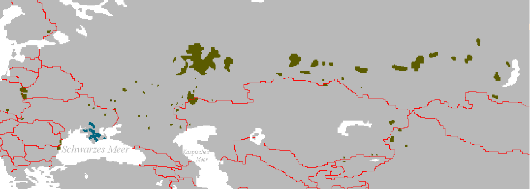
Verbreitungsgebiet der Turko-Tataren
- Beschreibung: Darstellungskarte mit den Siedlungsgebieten jener Völker, die sich heute als „Tataren“ bezeichnen bzw. sich von diesen herführen.
- Zeichner: Postmann Michael
- erstellt am: 13. Februar 2005
| Public domainPublic domainfalsefalse |
| |
This work has been released into the public domain by its author, Postmann Michael, at the англи Википедиа project. This applies worldwide. In case this is not legally possible: |
Captions
Add a one-line explanation of what this file represents
Items portrayed in this file
depicts англи
Файлын түүх
Огноо/цаг дээр дарж тухайн үеийнх нь файлын байдлыг харна уу.
| Огноо/Цаг | Жижиг зураг | Хэмжээ | Хэрэглэгч | Тайлбар | |
|---|---|---|---|---|---|
| одоогийн | 15:56, 3 Зургаадугаар сар 2024 | 1,077 × 384 (13 КБ) | Sakaiberian | Reverted to version as of 08:36, 10 July 2017 (UTC) | |
| 13:15, 26 Тавдугаар сар 2024 | 1,077 × 384 (10 КБ) | SteinsplitterBot | Bot: Image rotated by 180° | ||
| 08:36, 10 Долоодугаар сар 2017 | 1,077 × 384 (13 КБ) | Szczureq | Restored Crimean Tatars, with different coloring. | ||
| 20:52, 8 Арваннэгдүгээр сар 2011 | 1,077 × 384 (25 КБ) | Glossologist | Removed Crimean Tatars, which are a separate Turkic ethnic group. | ||
| 19:15, 8 Гуравдугаар сар 2006 | 1,077 × 384 (22 КБ) | Robert Weemeyer | Verbreitungsgebiet der Turko-Tataren * Beschreibung: Darstellungskarte mit den Siedlungsgebieten jener Völker, die sich heute als „Tataren“ bezeichen bzw. sich von diesen herführen. * Zeichner: Postmann Michael * erstellt am: 13. Februar 2005 {{PD |
Холбоос
Файлын хэрэглээ (бүх төсөл)
Дараах бусад вики энэ файлыг ашигладаг:
- af.wikipedia.org дахь хэрэглээ
- als.wikipedia.org дахь хэрэглээ
- an.wikipedia.org дахь хэрэглээ
- bs.wikipedia.org дахь хэрэглээ
- ca.wikipedia.org дахь хэрэглээ
- cs.wikipedia.org дахь хэрэглээ
- da.wikipedia.org дахь хэрэглээ
- de.wikipedia.org дахь хэрэглээ
- en.wikipedia.org дахь хэрэглээ
- en.wikiquote.org дахь хэрэглээ
- eo.wikipedia.org дахь хэрэглээ
- fa.wikipedia.org дахь хэрэглээ
- frr.wikipedia.org дахь хэрэглээ
- fr.wikipedia.org дахь хэрэглээ
- fy.wikipedia.org дахь хэрэглээ
- ga.wikipedia.org дахь хэрэглээ
- gl.wikipedia.org дахь хэрэглээ
- got.wikipedia.org дахь хэрэглээ
- hr.wikipedia.org дахь хэрэглээ
- hr.wikiquote.org дахь хэрэглээ
- hu.wikipedia.org дахь хэрэглээ
- la.wikipedia.org дахь хэрэглээ
- lt.wikipedia.org дахь хэрэглээ
- lv.wikipedia.org дахь хэрэглээ
- my.wikipedia.org дахь хэрэглээ
- nl.wikipedia.org дахь хэрэглээ
- oc.wikipedia.org дахь хэрэглээ
- pl.wikipedia.org дахь хэрэглээ
- sk.wikipedia.org дахь хэрэглээ
- stq.wikipedia.org дахь хэрэглээ
- su.wikipedia.org дахь хэрэглээ
- sv.wikipedia.org дахь хэрэглээ
- tk.wikipedia.org дахь хэрэглээ
- zh.wikipedia.org дахь хэрэглээ
Зургийн тухай мэдээлэл
Энэ файланд бодвол дижитал аппарат эсвэл сканнераас нэмэгдсэн нэмэлт мэдээлэл байна.
Хэрэв энэ файл анхныхаа байдлаас өөрчлөгдсөн бол зарим мэдээлэл нь одоогийн хувилбартайгаа нийцэхгүй байж магадгүй.
| Зургийн хөндлөн чанар | 28.35 dpc |
|---|---|
| Зургийн босоо чанар | 28.35 dpc |
| Файлыг өөрчлилсөн огноо ба цаг | 08:35, 10 Долоодугаар сар 2017 |