കൊളംബിയ, മേരിലാൻഡ്
From Wikipedia, the free encyclopedia
From Wikipedia, the free encyclopedia
കൊളംബിയ, അമേരിക്കൻ ഐക്യനാടുകളിലെ മേരിലാൻഡ് സംസ്ഥാനത്തെ ഹോവാർഡ് കൗണ്ടിയിലെ ഒരു സെൻസസ് നിയുക്ത സ്ഥലമാണ്. 10 സ്വയംഭരണ ഗ്രാമങ്ങൾ അടങ്ങുന്ന ഒരു ആസൂത്രിത നഗരമാണിത്. 2020 ലെ യു.എസ്. സെൻസസ് പ്രകാരം 104,681 ജനസംഖ്യയുണ്ടായിരുന്ന ഈ സെൻസസ് നിയുക്ത സ്ഥലം ബാൾട്ടിമോറിന് ശേഷം മേരിലാൻഡിലെ ഏറ്റവും ജനസംഖ്യയുള്ള രണ്ടാമത്തെ സമൂഹമാണ്.[4][5] ബാൾട്ടിമോറിനും വാഷിംഗ്ടൺ ഡിസിക്കും ഇടയിൽ സ്ഥിതി ചെയ്യുന്ന കൊളംബിയ ഔദ്യോഗികമായി ബാൾട്ടിമോർ മെട്രോപൊളിറ്റൻ പ്രദേശത്തിൻറെ ഭാഗമാണ്.
കൊളംബിയ, മേരിലാൻഡ് | |
|---|---|
Census-designated place | |
 Columbia Town Center in Columbia along Lake Kittamaqundi | |
| Motto(s): "The Next America!"[1] | |
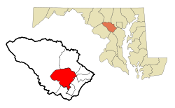
 Location of Columbia, Maryland | |
| Coordinates: 39°12′13″N 76°51′25″W | |
| Country | |
| State | |
| County | Howard |
| Founded | June 21, 1967[2] |
| സ്ഥാപകൻ | James Rouse |
| നാമഹേതു | Columbia (personification) |
| • ആകെ | 32.19 ച മൈ (83.37 ച.കി.മീ.) |
| • ഭൂമി | 31.93 ച മൈ (82.71 ച.കി.മീ.) |
| • ജലം | 0.26 ച മൈ (0.66 ച.കി.മീ.) |
| ഉയരം | 407 അടി (124 മീ) |
(2020) | |
| • ആകെ | 1,04,681 |
| • ജനസാന്ദ്രത | 3,278.04/ച മൈ (1,265.68/ച.കി.മീ.) |
| The CDP includes areas not part of Columbia proper as defined by the Columbia Association. | |
| സമയമേഖല | UTC−5 (Eastern (EST)) |
| • Summer (DST) | UTC−4 (EDT) |
| ZIP Codes | 21044-21046 |
| ഏരിയകോഡ് | 410, 443, 667 |
| FIPS code | 24-19125 |
| GNIS feature ID | 0590002 |
| വെബ്സൈറ്റ് | columbiaassociation.com |
Seamless Wikipedia browsing. On steroids.
Every time you click a link to Wikipedia, Wiktionary or Wikiquote in your browser's search results, it will show the modern Wikiwand interface.
Wikiwand extension is a five stars, simple, with minimum permission required to keep your browsing private, safe and transparent.