File:Great_Schism_1054_with_former_borders.png
From Wikipedia, the free encyclopedia
ഈ പ്രിവ്യൂവിന്റെ വലിപ്പം: 560 × 599 പിക്സലുകൾ. മറ്റ് റെസലൂഷനുകൾ: 224 × 240 പിക്സലുകൾ | 448 × 480 പിക്സലുകൾ | 717 × 768 പിക്സലുകൾ | 957 × 1,024 പിക്സലുകൾ | 2,000 × 2,141 പിക്സലുകൾ.
പൂർണ്ണ വലിപ്പം (2,000 × 2,141 പിക്സൽ, പ്രമാണത്തിന്റെ വലിപ്പം: 420 കെ.ബി., മൈം തരം: image/png)
| ഈ പ്രമാണം വിക്കിമീഡിയ കോമൺസിൽ നിന്നുള്ളതാണ്. പ്രമാണത്തെക്കുറിച്ചുള്ള വിവരണം താഴെ കൊടുത്തിരിക്കുന്നു.
|
| ഈ പ്രമാണത്തിന്റെ വസ്തുതാപരമായ കൃത്യത തർക്കത്തിലാണ്. See File talk:Great Schism 1054 with former borders.png#Numerous problems, map is unreliable. |

|
ഈ religion map ചിത്രം വെക്റ്റർ ഗ്രാഫിക്സ് ഉപയോഗിച്ച് എസ്.വി.ജി. പ്രമാണമായി പുനർനിർമ്മിക്കേണ്ടതാണ്. അങ്ങനെ ചെയ്യുന്നതുകൊണ്ട് പല ഗുണങ്ങളുമുണ്ട്; കൂടുതൽ വിവരങ്ങൾക്ക് മെച്ചപ്പെടുത്തുവാനുള്ള മീഡിയകൾ കാണുക. ഈ ചിത്രത്തിന്റെ എസ്.വി.ജി. പതിപ്പ് കൈവശമുണ്ടെങ്കിൽ ദയവായി അപ്ലോഡ് ചെയ്യുക. അപ്ലോഡ് ചെയ്ത ശേഷം ഈ ഫലകം {{vector version available|പുതിയ ചിത്രത്തിന്റെ പേര്.svg}} എന്ന് മാറ്റിച്ചേർക്കുക.
|
ചുരുക്കം
| വിവരണംGreat Schism 1054 with former borders.png |
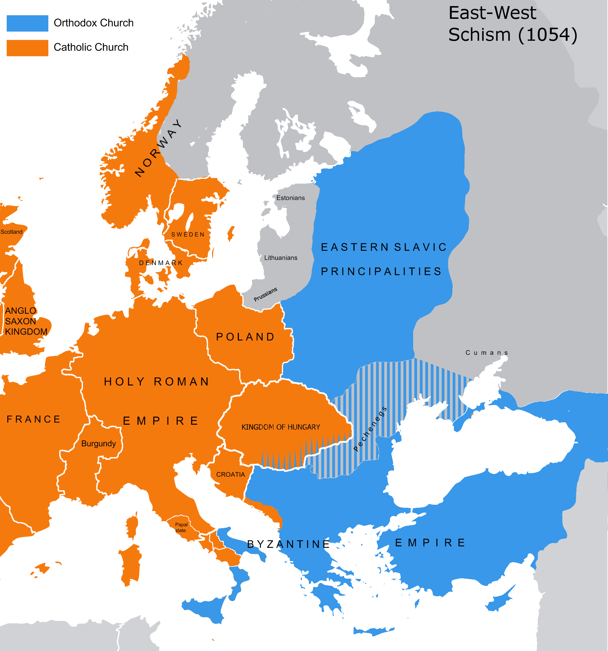
English: The map of the eastern/western allegiances in 1054 with the former country borders.
Español: El mapa de las creencias en el este/oeste en 1054 con las fronteras del país anterior. Los puntos representan concentraciones de minorías y no ubicaciones específicas. Las líneas rayadas representan cohabitaciones religiosas y no mayorías (que están representadas por colores sólidos).
Deutsch: Karte über das Morgenländische Schisma mit den ehemaligen Landesgrenzen. Die schraffierten Linien stellen religiöse Zusammenleben und keine Mehrheiten dar (die durch Vollfarben dargestellt werden).
Magyar: A nagy kelet-nyugati egyházszakadás térképe az 1054-nek megfelelő határokkal. A pontok a kisebbségek koncentrációját jelölik, nem pedig meghatározott helyeket. A sraffozott vonalak a vallási együttéléseket jelölik, nem pedig a többséget (amelyeket egyszínű színek jelölnek). |
|||
| തീയതി | 04.09.2010. | |||
| സ്രോതസ്സ് | Source: Westermanns Atlas zur Weltgeschichte, 1957, p. 64-5, maps titled "Staaten u. Bekenntnisse im Mittelmeerraum nach den ersten Kreuzzügen (um 1190)" (p. 64) and "Mittelmeerwelt und Vorderasien vor Beginn der Kreuzzüge (1096)" (p. 65) and Alexander Kazhdan (dir.), Oxford Dictionary of Byzantium, Oxford University Press, 1991, 1re éd., 3 tom. (ISBN 978-0-19-504652-6, LCCN 90023208), art. « Patriarchates », vol. 3, pp. 1599-1600. | |||
| സ്രഷ്ടാവ് | Tobi85 | |||
| അനുമതി (ഈ പ്രമാണത്തിന്റെ പുനരുപയോഗം) |
|
|||
| മറ്റു പതിപ്പുകൾ | ഈ പ്രമാണത്തിൽ നിന്നും സൃഷ്ടിച്ചവ: Great Schism 1054 with former borders-ar.png |
അനുമതി
| Public domainPublic domainfalsefalse |
| ഈ സൃഷ്ടിയുടെ പകർപ്പവകാശ ഉടമയായ ഞാൻ, ഈ സൃഷ്ടി പൊതുസഞ്ചയത്തിൽ പ്രസിദ്ധീകരിച്ചിരിക്കുന്നു. ഇത് ആഗോള തലത്തിൽ ബാധകമാണ്. ചില രാജ്യങ്ങളിൽ ഇത് നിയമപ്രകാരം സാദ്ധ്യമല്ലെന്ന് വന്നേക്കാം; അങ്ങനെയെങ്കിൽ: ഈ സൃഷ്ടി, നിയമപ്രകാരം നിബന്ധനകൾ ഉണ്ടെങ്കിൽ അവയൊഴിച്ച്, യാതൊരു നിബന്ധനകളും ഇല്ലാതെ ഏതൊരാൾക്കും ഏതൊരു ഉപയോഗത്തിനും, ഉപയോഗപ്പെടുത്തുവാൻ ഞാൻ അനുവദിച്ചിരിക്കുന്നു. |
_en.png)
.png)
.jpg)
തലവാചകങ്ങൾ
ഈ പ്രമാണം എന്തിനെ പ്രതിനിധീകരിക്കുന്നുവെന്ന ഒറ്റവരി വിശദീകരണം ചേർക്കുക
ഈ പ്രമാണത്തിൽ ചിത്രീകരിച്ചിരിക്കുന്ന ഇനങ്ങൾ
സൃഷ്ടിയിലുള്ളത്
image/png
പ്രമാണ നാൾവഴി
ഏതെങ്കിലും തീയതി/സമയ കണ്ണിയിൽ ഞെക്കിയാൽ പ്രസ്തുതസമയത്ത് ഈ പ്രമാണം എങ്ങനെയായിരുന്നു എന്നു കാണാം.
| തീയതി/സമയം | ലഘുചിത്രം | അളവുകൾ | ഉപയോക്താവ് | അഭിപ്രായം | |
|---|---|---|---|---|---|
| നിലവിലുള്ളത് | 13:16, 9 ജൂലൈ 2023 | | 2,000 × 2,141 (420 കെ.ബി.) | Veverve | Reverted to version as of 21:25, 11 November 2022 (UTC): this is a huge extrapolation to make based solely on the fact that there were some Byzantine churches in Hungary |
| 15:01, 19 മാർച്ച് 2023 |  | 2,000 × 2,141 (439 കെ.ബി.) | Moodylo333 | Reverted to 8 November 2017 according with Dora Wiebenson, József Sisa, Pál Lövei, "The architecture of historic Hungary" (p. 11) who admit the presence of byzantine churches in Eastern Hungary. | |
| 21:25, 11 നവംബർ 2022 |  | 2,000 × 2,141 (420 കെ.ബി.) | Gyalu22 | As Veverve said, no personal opinions should be used. The previous status in Hungary was drawn by Cepleanu who referred to the Westermanns Atlas in the talk page. But that atlas shows the situation very differently. | |
| 19:58, 23 ഒക്ടോബർ 2022 |  | 2,000 × 2,141 (479 കെ.ബി.) | Veverve | Reverted to version as of 11:04, 1 June 2022 (UTC) original research and personnal opinions should no be used | |
| 19:12, 23 ഒക്ടോബർ 2022 |  | 2,000 × 2,141 (492 കെ.ബി.) | Gyalu22 | Religion was not an ethnic question. Transylvania was a religiously diverse region, but Catholicism was already dominant to Alba Iulia | |
| 11:04, 1 ജൂൺ 2022 |  | 2,000 × 2,141 (479 കെ.ബി.) | Moodylo333 | Reliable version with Alexander Kazhdan (dir.), Oxford Dictionary of Byzantium, New York et Oxford, Oxford University Press, 1991, 1re éd., 3 tom. (ISBN 978-0-19-504652-6 et 0-19-504652-8, LCCN 90023208), 1991, art. « Patriarchates », vol. 3, pp. 1599-1600. | |
| 13:51, 1 ഫെബ്രുവരി 2022 |  | 2,000 × 2,141 (488 കെ.ബി.) | Moodylo333 | Reverted to version as of 20:17, 8 July 2018 (UTC) without Bogomils (off topic) | |
| 13:49, 1 ഫെബ്രുവരി 2022 |  | 2,000 × 2,141 (488 കെ.ബി.) | Moodylo333 | Reverted to version as of 20:15, 8 July 2018 (UTC) : COM:CROP | |
| 09:41, 26 നവംബർ 2021 |  | 2,000 × 2,141 (420 കെ.ബി.) | Veverve | Reverted to version as of 15:53, 26 October 2011 (UTC) revert to version closer to the Westermanns Atlas zur Weltgeschichte, see File_talk:Great_Schism_1054_with_former_borders.png#Numerous_problems,_map_is_unreliable | |
| 23:18, 29 മേയ് 2021 |  | 2,000 × 2,141 (494 കെ.ബി.) | Ceha | Catholic-ortodox borders in the southeast |
പ്രമാണത്തിന്റെ ഉപയോഗം
ഈ പ്രമാണം വിക്കിയിലെ താളുകളിലൊന്നിലും ഉപയോഗിക്കുന്നില്ല.
പ്രമാണത്തിന്റെ ആഗോള ഉപയോഗം
താഴെ കൊടുത്തിരിക്കുന്ന മറ്റ് വിക്കികൾ ഈ പ്രമാണം ഉപയോഗിക്കുന്നു:
- ar.wikipedia.org സംരംഭത്തിലെ ഉപയോഗം
- ca.wikipedia.org സംരംഭത്തിലെ ഉപയോഗം
- cs.wikipedia.org സംരംഭത്തിലെ ഉപയോഗം
- de.wikipedia.org സംരംഭത്തിലെ ഉപയോഗം
- de.wikibooks.org സംരംഭത്തിലെ ഉപയോഗം
- en.wikipedia.org സംരംഭത്തിലെ ഉപയോഗം
- fr.wikipedia.org സംരംഭത്തിലെ ഉപയോഗം
- ga.wikipedia.org സംരംഭത്തിലെ ഉപയോഗം
- hu.wikipedia.org സംരംഭത്തിലെ ഉപയോഗം
- ro.wikipedia.org സംരംഭത്തിലെ ഉപയോഗം
- www.wikidata.org സംരംഭത്തിലെ ഉപയോഗം
മെറ്റാഡാറ്റ
ഡിജിറ്റൽ ക്യാമറയോ, സ്കാനറോ ഉപയോഗിച്ച് നിർമ്മിച്ചപ്പോഴോ ഡിജിറ്റൈസ് ചെയ്തപ്പോഴോ ചേർക്കപ്പെട്ട അധികവിവരങ്ങൾ ഈ പ്രമാണത്തിലുണ്ട്. ഈ പ്രമാണം അതിന്റെ ആദ്യസ്ഥിതിയിൽ നിന്നും മാറ്റിയിട്ടുണ്ടെങ്കിൽ, ചില വിവരങ്ങൾ ഇപ്പോഴുള്ള പ്രമാണത്തെ പൂർണ്ണമായി പ്രതിനിധീകരിക്കണമെന്നില്ല.
| തിരശ്ചീന റെസലൂഷൻ | 28.35 dpc |
|---|---|
| ലംബ റെസലൂഷൻ | 28.35 dpc |
"https://ml.wikipedia.org/wiki/പ്രമാണം:Great_Schism_1054_with_former_borders.png" എന്ന താളിൽനിന്ന് ശേഖരിച്ചത്