File:Map_of_Assyria.png
From Wikipedia, the free encyclopedia
Size of this preview: 800 × 550 pixels. Other resolutions: 320 × 220 pixels | 640 × 440 pixels | 1,024 × 704 pixels | 1,280 × 880 pixels | 1,983 × 1,363 pixels.
Original file (1,983 × 1,363 pixels, file size: 160 KB, MIME type: image/png)
This file is from Wikimedia Commons and may be used by other projects. The description on its file description page there is shown below.
| DescriptionMap of Assyria.png |
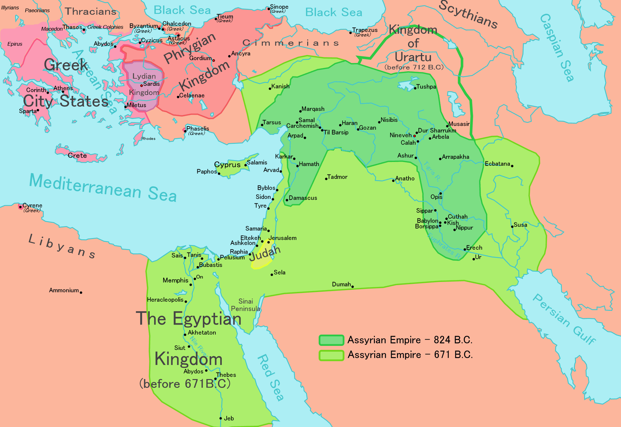
[takatā] English: Map of the Assyrian Empire Español: Extensión del Imperio Asirio Polski: Mapa Asyrii w 824 i 671 r. p.n.e. Português: Extensão do Império Assírio العربية : خارطة الإمبراطوريَّة الآشوريَّة. فارسی : نقشه امپراتوری آشور |
|||||
| Date | ||||||
| Source |
Own work data from
|
|||||
| Author | Ningyou | |||||
| Permission (Reusing this file) |
|
|||||
| Other versions |
[takatā]
|


Captions
Add a one-line explanation of what this file represents
Map of the Assyrian Empire 824 BCE to 671 BCE
Мапа Ассирійської імперії
Items portrayed in this file
depicts Ingarihi
copyright license Ingarihi
inception Ingarihi
26 Hui-tanguru 2006
media type Ingarihi
image/png
File history
Click on a date/time to view the file as it appeared at that time.
| Date/Time | Thumbnail | Dimensions | User | Comment | |
|---|---|---|---|---|---|
| current | 12:32, 24 Mei 2018 | | 1,983 × 1,363 (160 KB) | Capmo | corrected typos in Trapezus and Hamath |
| 18:33, 12 Hepetema 2010 |  | 1,983 × 1,363 (148 KB) | Ras67 | cropped and squeezed | |
| 00:35, 1 Hepetema 2010 |  | 1,985 × 1,365 (161 KB) | Capmo | typo in word "Aegean"; 256 colors | |
| 21:05, 21 Hānuere 2010 |  | 1,985 × 1,365 (645 KB) | Megistias | Border around map, Details | |
| 14:51, 26 Pēpuere 2006 |  | 1,985 × 1,365 (640 KB) | Ningyou | This is a large map of Assyria, made by Ningyou. For translations of this map, contact Ningyou. Category:Assyria |
File usage
The following page uses this file:
Global file usage
The following other wikis use this file:
- Usage on af.wikipedia.org
- Usage on als.wikipedia.org
- Usage on am.wikipedia.org
- Usage on an.wikipedia.org
- Usage on arc.wikipedia.org
- Usage on ar.wikipedia.org
- Usage on ast.wikipedia.org
- Usage on azb.wikipedia.org
- Usage on az.wikipedia.org
- Usage on ba.wikipedia.org
- Usage on be.wikipedia.org
- Usage on bg.wikipedia.org
- Usage on bn.wikipedia.org
- Usage on ckb.wikipedia.org
- Usage on cs.wikipedia.org
- Usage on cv.wikipedia.org
- Usage on cy.wikipedia.org
- Usage on dag.wikipedia.org
- Usage on da.wikipedia.org
- Usage on de.wikipedia.org
- Usage on el.wikipedia.org
- Usage on en.wikipedia.org
View more global usage of this file.
Metadata
This file contains additional information, probably added from the digital camera or scanner used to create or digitize it.
If the file has been modified from its original state, some details may not fully reflect the modified file.
| Horizontal resolution | 37.8 dpc |
|---|---|
| Vertical resolution | 37.8 dpc |
Retrieved from "https://mi.wikipedia.org/wiki/File:Map_of_Assyria.png"