Plaetje:Gelre1477.png
From Wikipedia, the free encyclopedia
Oearsprunkelik bestandj ((772 × 673 pixel, besjtandsgruutde: 937 kB, MIME type: image/png))
Dit besjtandj kump van Wikimedia Commons en kin ouch in anger projekte gebroek waere. De pagina mit de besjtandjsbesjrieving wurt hiejónger weergegaeve.
Besjrieving
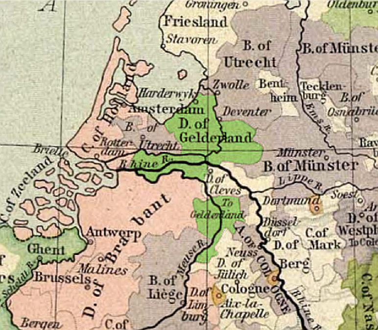
| BesjrievingGelre1477.png |
Français : Carte du duché de Gueldre, en 1477
English: Map of duchy of Guelders, in 1477 |
||
| Datum | |||
| Brón |
|
||
| Sjriever | original map: de:Velhagen & Klasing |
Licentie:
| Public domainPublic domainfalsefalse |
De auteur overleed in 1934, dus dit werk bevindt zich in het publiek domein in landen en gebieden waar de auteursrechttermijn het leven van de auteur plus 80 jaar of minder is. | |
| Van dit bestandj is vasgesteld det t'r gein bekindje sjrieversaansprake op ruste, inbegrepe van anger kórtbie rechte. | |
https://creativecommons.org/publicdomain/mark/1.0/PDMCreative Commons Public Domain Mark 1.0falsefalse
| Public domainPublic domainfalsefalse |
This work is in the public domain because it was published in the United States between 1929 and 1963, and although there may or may not have been a copyright notice, the copyright was not renewed. For further explanation, see Commons:Hirtle chart and the copyright renewal logs. Note that it may still be copyrighted in jurisdictions that do not apply the rule of the shorter term for US works (depending on the date of the author's death), such as Canada (70 years p.m.a.), Mainland China (50 years p.m.a., not Hong Kong or Macao), Germany (70 years p.m.a.), Mexico (100 years p.m.a.), Switzerland (70 years p.m.a.), and other countries with individual treaties.
العربية ∙ Deutsch ∙ English ∙ español ∙ français ∙ galego ∙ italiano ∙ 日本語 ∙ 한국어 ∙ македонски ∙ português ∙ português do Brasil ∙ русский ∙ sicilianu ∙ slovenščina ∙ українська ∙ 简体中文 ∙ 繁體中文 ∙ +/− |
 |
Orzjineel uploadlogbook
- uploadé sur Wikipédia NL par User:Känsterle le 17 décembre 2005.
- Highlighting of Guelders: User:Eugene van der Pijll.
Bijschriften
Items getoond in dit bestand
beeldt af Nederlands
maker Nederlands
William Robert Shepherd Nederlands
datum van oprichting of creatie Nederlands
1926
MIME-type Nederlands
image/png
Besjtandshistorie
Klik op 'ne datum/tied óm 't besjtand te zeen wie 't oetzaog op det tiedsjtip.
| Datum/Tied | Miniatuurplaetje | Aafmaetinge | Gebroeker | Kómmentaar | |
|---|---|---|---|---|---|
| hujig | 13 mei 2011 22:13 | | 772 × 673 (937 kB) | Hans Erren | corrected southern boundary to include ambt montfort. Reloaded original perry castaneda map, Rotated to true north, adjusted gamma, sharpened, fill coloured area in more pastel tone. |
| 25 fib 2006 21:02 |  | 334 × 277 (183 kB) | Eugene van der Pijll | ||
| 25 fib 2006 20:20 |  | 334 × 277 (165 kB) | Odejea | == Description == Carte du duché de Gueldre, en 1477 Origine : * collection de cartes de l'Université du Texas (http://www.lib.utexas.edu/maps/). Ces cartes sont dans le domaine public (http://www.lib.utexas.edu/maps/faq.html#3.html). * uploadé sur W |
Plaetjesverwiezinge
Dit plaetje weurt op de volgende pazjena's gebroek:
Globaal besjtandjsgebroek
De volgende anger wiki's gebroeke dit bestandj:
- Gebroek in af.wikipedia.org
- Gebroek in ar.wikipedia.org
- Gebroek in br.wikipedia.org
- Gebroek in ca.wikipedia.org
- Gebroek in da.wikipedia.org
- Gebroek in de.wikipedia.org
- Gebroek in en.wikipedia.org
- Gebroek in et.wikipedia.org
- Gebroek in fr.wikipedia.org
- Gebroek in he.wikipedia.org
- Gebroek in hu.wikibooks.org
- Gebroek in it.wikipedia.org
- Gebroek in nds-nl.wikipedia.org
- Gebroek in nl.wikipedia.org
- Gebroek in nn.wikipedia.org
- Gebroek in no.wikipedia.org
- Gebroek in pl.wikipedia.org
- Gebroek in pt.wikipedia.org
- Gebroek in ru.wikipedia.org
- Gebroek in th.wikipedia.org