Plaetje:Caspian_Sea_from_orbit.jpg
From Wikipedia, the free encyclopedia
Oearsprunkelik bestandj ((4.400 × 5.600 pixel, besjtandsgruutde: 3,44 MB, MIME type: image/jpeg))
Dit besjtandj kump van Wikimedia Commons en kin ouch in anger projekte gebroek waere. De pagina mit de besjtandjsbesjrieving wurt hiejónger weergegaeve.
Besjrieving
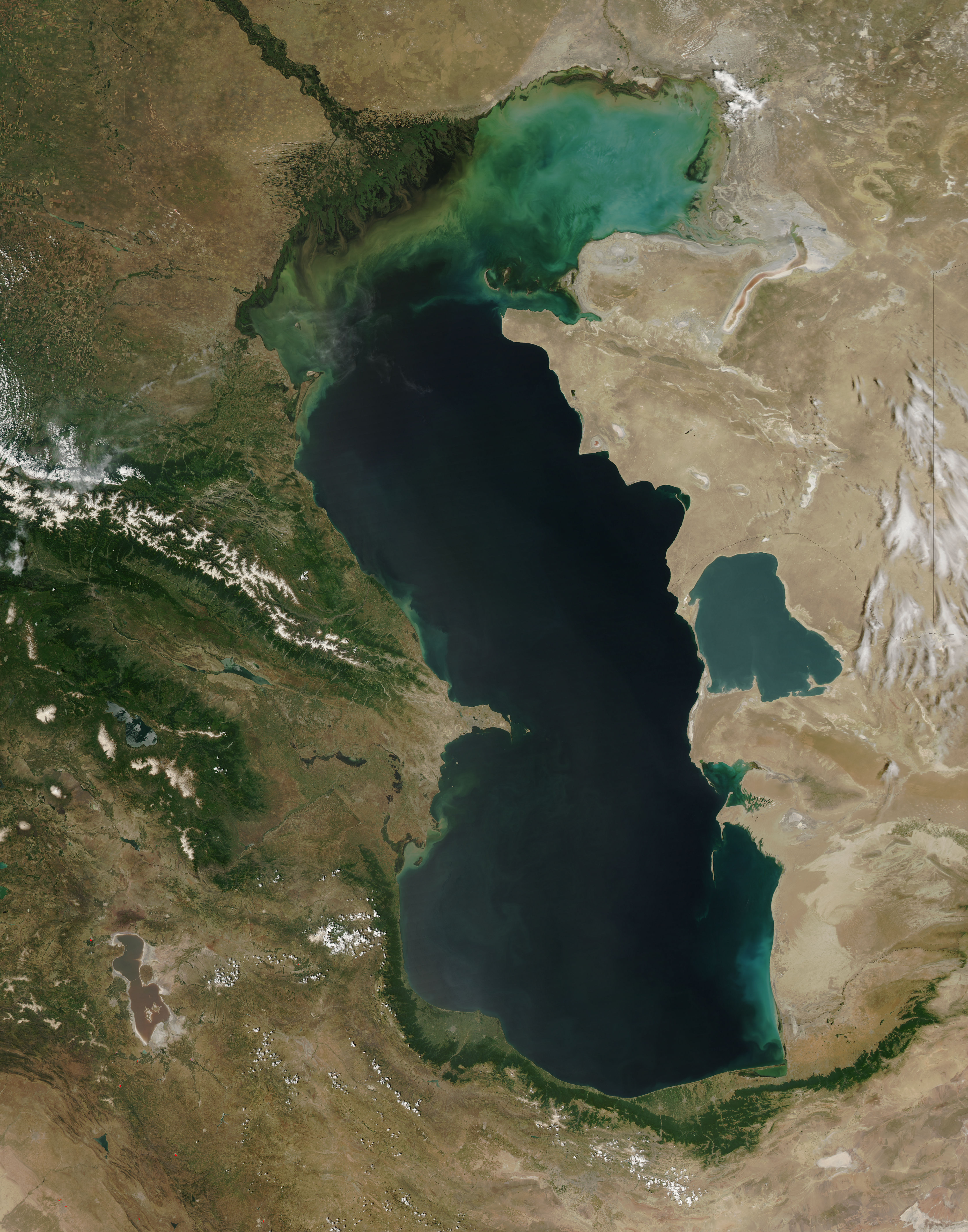
| BesjrievingCaspian Sea from orbit.jpg |
العربية: منظرٌ من مدار الأرض لِبحر قزوين. التعليق الأصلي: كما أوردته وكالة الناسا: ::"القسم الشمالي من بحر قزوين يُعاني من ظاهرةٍ تُعرف باسم التخثث أو إغناء الماء، وهي تلك الحالة التي تتسببُ فيها الأسمدة الزراعيَّة المُنسابة من خِلال مياه الري والأمطار بِنُمو الطحالب في المياه. يُؤدي نُفوق وتحلُّل تلك الطحالب إلى حرمان المياه من الأكسجين، ممَّا يُؤدي بِدوره إلى الإضرار بِالحياة البريَّة بِطبيعة الحال. هذه الصُورة لِبحر قزوين تُظهرُ بعض الدوَّامات الخضراء والزرقاء على مقرُبةٍ من مصب نهر الڤولغا (أعلى الوسط)، ممَّا يدُل على وُجود كميَّةٍ من الطحالب. اللون الأزرق اللامع في القسم الشمالي الشرقي من البحر قد يكون تولَّد نتيجة اختلاط بعض النباتات بِالترسُبات، نظرًا لِأنَّ هذا الموقع هو أكثر المناطق ضُحولةً في البحر.
English: This is a view from orbit of the Caspian Sea as imaged by the MODIS sensor on the Terra satellite. Caption: The original caption from NASA: ::"The northern part of the Caspian Sea is plagued by a process called eutrophication, in which agricultural run-off rich in fertilizers stimulates rampant growth of algae in the water. The death and decay of these algae robs the water of oxygen, with obvious negative consequences for aquatic life. This image of the Caspian Sea shows swirls of green and blue near the mouth of the Volga River (top center), which indicate the presence of algae. The bright blue color of the northeastern part of the sea may be due to a mixture of plant life and sediment, for this is where the sea is most shallow. This image is from the Moderate Resolution Imaging Spectroradiometer (MODIS) on the Terra satellite on June 11, 2003.
Español: El Mar Caspio visto desde la órbita terrestre
فارسی: تصویر ماهوارهای از دریای خزر
Тоҷикӣ: Тасвири Баҳр Каспӣ аз осмон |
| Datum | |
| Brón |
http://visibleearth.nasa.gov/view_rec.php?id=5514
|
| Sjriever | Jeff Schmaltz, MODIS Rapid Response Team, NASA/GSFC |
| Anger versies | Derivative works of this file: Caspian Sea from orbit-NoRedLines.jpg |
|

|
Deze afbeelding is beoordeeld op basis van de criteria voor waardevolle afbeeldingen en wordt beschouwd als de meest waardevolle afbeelding op Commons binnen het onderwerpgebied: Satellite images of the Caspian Sea. Deze nominatie kan bekeken worden op Commons:Valued image candidates/Caspian Sea from orbit.jpg. |
Licentie:
| Public domainPublic domainfalsefalse |
| Dit bestand bevindt zich in het publiek domein, omdat het gemaakt is door de NASA. In de reproductierichtlijnen van de NASA staat dat "NASA-materiaal niet beschermd wordt door auteursrecht, tenzij anders vermeld". | ||
 |
Waarschuwingen:
|
Bijschriften
Items getoond in dit bestand
beeldt af Nederlands
kwaliteitsbeoordeling op Commons Nederlands
waardevolle afbeelding op Wikimedia Commons Nederlands
datum van oprichting of creatie Nederlands
11 jun 2003
MIME-type Nederlands
image/jpeg
checksum Nederlands
67680b9374004de157c7612c1187c3ad60f363ee
datagrootte Nederlands
3.608.474 byte
hoogte Nederlands
5.600 pixel
breedte Nederlands
4.400 pixel
Besjtandshistorie
Klik op 'ne datum/tied óm 't besjtand te zeen wie 't oetzaog op det tiedsjtip.
| Datum/Tied | Miniatuurplaetje | Aafmaetinge | Gebroeker | Kómmentaar | |
|---|---|---|---|---|---|
| hujig | 14 jun 2010 11:16 | | 4.400 × 5.600 (3,44 MB) | Originalwana | higher res |
| 8 fib 2005 17:10 |  | 550 × 700 (67 kB) | Pixeltoo | Caspian sea by space Nasa |
Plaetjesverwiezinge
Dit plaetje weurt op de volgende pazjena's gebroek:
Globaal besjtandjsgebroek
De volgende anger wiki's gebroeke dit bestandj:
- Gebroek in af.wikipedia.org
- Gebroek in als.wikipedia.org
- Gebroek in am.wikipedia.org
- Gebroek in ang.wikipedia.org
- Gebroek in an.wikipedia.org
- Gebroek in arc.wikipedia.org
- Gebroek in ar.wikipedia.org
- بحر قزوين
- ويكيبيديا:صور مختارة/الفضاء والكون/نظرة إلى الخلف
- ويكيبيديا:ترشيحات الصور المختارة/بحر قزوين
- ويكيبيديا:صورة اليوم المختارة/ديسمبر 2016
- قالب:صورة اليوم المختارة/2016-12-23
- مستخدم:قائمة أكبر البحيرات والبحار في المجموعة الشمسية
- ويكيبيديا:صورة اليوم المختارة/يوليو 2020
- قالب:صورة اليوم المختارة/2020-07-16
- ويكيبيديا:صورة اليوم المختارة/يوليو 2023
- قالب:صورة اليوم المختارة/2023-07-26
- Gebroek in arz.wikipedia.org
- Gebroek in ast.wikipedia.org
- Gebroek in as.wikipedia.org
- Gebroek in av.wikipedia.org
- Gebroek in azb.wikipedia.org
- Gebroek in az.wikipedia.org
- Gebroek in bat-smg.wikipedia.org
- Gebroek in be.wikipedia.org
- Gebroek in bew.wikipedia.org
- Gebroek in bg.wikipedia.org
- Gebroek in bh.wikipedia.org
- Gebroek in bn.wikipedia.org
- Gebroek in br.wikipedia.org
- Gebroek in bs.wikipedia.org
- Gebroek in bxr.wikipedia.org
- Gebroek in ca.wikipedia.org
- Gebroek in ce.wikipedia.org
- Gebroek in ckb.wikipedia.org
- Gebroek in co.wikipedia.org
- Gebroek in cs.wikipedia.org
Bekiek wikiwied gebroek van dit bestandj.
Metadata
Dit besjtand bevat extra gegaeves, waorsjienlik door de digitale camera of scanner biegevoog. Es 't oersjprunkelik besjtand aangepas is, kin 't zeen dat sómmige details neet mie bie 't gewiezigde plaetje hure.
| _error | 0 |
|---|