Fasciculus:Aranislandssatmap.jpg
From Wikipedia, the free encyclopedia
Nulla maior resolutio exstat.
Aranislandssatmap.jpg (555 × 352 elementa imaginalia, magnitudo fasciculi: 115 chiliocteti, typus MIME: image/jpeg)
Hic fasciculus apud Vicimedia Communia iacet; in aliis inceptis adhiberi potest. Contenta paginae descriptionis fasciculi subter monstrantur.
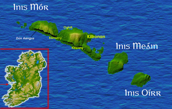
Aran Islands map from sat. Personal image amended from sat page here
Author Kanchelskis.

|
Licet hoc documentum exscribere vel distribuere vel demutare sub GNU Liberarum Litterarum Licentiae conditionibus in editione 1.2 aut in ulla editione recentiori a Fundatione Liberarum Programmationis Partium publicata; praeterquam Sectiones Immutabiles et Verba Involucra Adversa et Aversa. Licentiae exemplar praesto est in sectione intitulata GNU Free Documentation License.http://www.gnu.org/copyleft/fdl.htmlGFDLGNU Free Documentation Licensetruetrue |
| This file is licensed under the Creative Commons Attribution-Share Alike 3.0 Unported license. | ||
| ||
| This licensing tag was added to this file as part of the GFDL licensing update.http://creativecommons.org/licenses/by-sa/3.0/CC BY-SA 3.0Creative Commons Attribution-Share Alike 3.0truetrue |

|
This locator map image could be re-created using vector graphics as an SVG file. This has several advantages; see Commons:Media for cleanup for more information. If an SVG form of this image is available, please upload it and afterwards replace this template with
{{vector version available|new image name}}.
It is recommended to name the SVG file “Aranislandssatmap.svg”—then the template Vector version available (or Vva) does not need the new image name parameter. |
 | This locator map image was uploaded in the JPEG format even though it consists of non-photographic data. This information could be stored more efficiently or accurately in the PNG or SVG format. If possible, please upload a PNG or SVG version of this image without compression artifacts, derived from a non-JPEG source (or with existing artifacts removed). After doing so, please tag the JPEG version with {{Superseded|NewImage.ext}} and remove this tag. This tag should not be applied to photographs or scans. If this image is a diagram or other image suitable for vectorisation, please tag this image with {{Convert to SVG}} instead of {{BadJPEG}}. If not suitable for vectorisation, use {{Convert to PNG}}. For more information, see {{BadJPEG}}. |  |
Captions
Add a one-line explanation of what this file represents
Items portrayed in this file
depicts Anglica
copyright status Anglica
copyrighted Anglica
media type Anglica
image/jpeg
checksum Anglica
2b9aa5add03bf30713aee5b896abfc1258295726
data size Anglica
117 749 byte
352 pixel
555 pixel
Historia fasciculi
Presso die vel tempore fasciculum videbis, sicut tunc temporis apparuit.
| Dies/Tempus | Minutio | Dimensiones | Usor | Sententia | |
|---|---|---|---|---|---|
| recentissima | 10:39, 27 Iunii 2005 | | 555 × 352 (115 chiliocteti) | Kanchelskis | better version |
| 08:02, 27 Iunii 2005 |  | 555 × 352 (116 chiliocteti) | Kanchelskis | Aran Islands map from sat. Personal image amended from sat page [http://commons.wikimedia.org/wiki/Image:Topography_Ireland.jpg here] Author Kanchelskis. {{GFDL}} |
Nexus ad fasciculum
Ad hunc fasciculum nectit:
Usus fasciculi per inceptus Vicimediorum
Quae incepta Vici fasciculo utuntur:
- Usus in br.wikipedia.org
- Usus in cy.wikipedia.org
- Usus in da.wikipedia.org
- Usus in el.wikipedia.org
- Usus in en.wikipedia.org
- Usus in es.wikipedia.org
- Usus in et.wikipedia.org
- Usus in fi.wikipedia.org
- Usus in fr.wikipedia.org
- Usus in ga.wikipedia.org
- Usus in it.wikipedia.org
- Usus in it.wikivoyage.org
- Usus in mt.wikipedia.org
- Usus in nds.wikipedia.org
- Usus in pl.wikipedia.org
- Usus in zh.wikipedia.org
Metadata
Hic fasciculus alias res continet, saepius a machina originatore additas, et (si fasciculus postea recensus sit) fortasse corrigendas.
| Orientatio | Normalis |
|---|---|
| Resolutio horizontalis | 72 dpi |
| Resolutio verticalis | 72 dpi |
| Software used | Adobe Photoshop CS Windows |
| Dies et hora mutationis | 12:38, 27 Iunii 2005 |
| Spatium colorimetricum | Uncalibrated |