File:Czechoslovakia_I.png
From Wikipedia, the free encyclopedia
Myns an ragwel ma: 800 × 364 piksel. Klerderyow erel: 320 × 146 piksel | 640 × 291 piksel | 1,128 × 513 piksel.
Restren wreydhek (1,128 × 513 piksel, myns an restren: 66 KB, eghen MIME: image/png)
| Restren dhyworth Wikimedia Commons yw hebma. Yma diskwedhys a-woles derivadow dhyworth y folen deskrifans ena. | Mos dhe folen an restren war Wikimedia Commons |
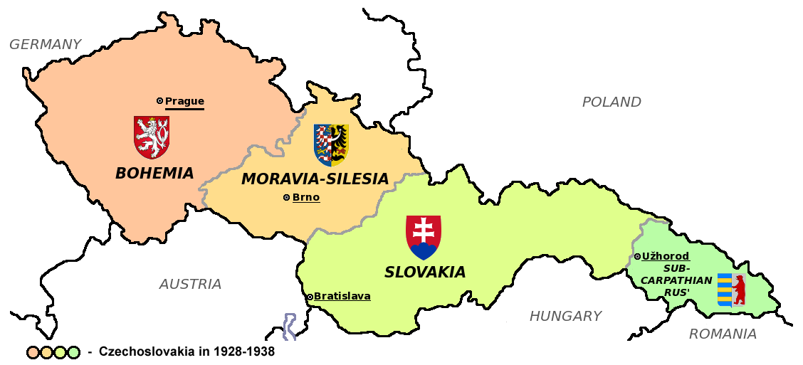
| DeskrifansCzechoslovakia I.png |
Čeština: Zemská mapa Československa v letech 1928 až 1938 s vyznačenými zemskými hlavními městy a znaky jednotlivých zemí English: Maps of Czechoslovakia in 1928-1938 with marked borders of all four Czechoslovak countries and their coats of arms and regional capital cities
Based on Image:Czechoslovakia_COA_medium.svg. * |
| Dedhyans | (UTC) |
| Pennfenten | |
| Awtour | |
| Other versions |
Derivative works of this file: |
| This is a retouched picture, which means that it has been digitally altered from its original version. Modifications: Simplified map. The original can be viewed here: CarpathianRutheniaCoA.svg:
|
Yma an restren ma yn-dann an leshyans Creative Commons Attribution-Share Alike 3.0 Unported.
- Yma'n gwir dhywgh:
- a ranna – a dhasskrifa, lesranna ha treuskorra an ober
- a gemyska – a aswiwa an ober
- Yn-dann an ragselyow a syw:
- askrifans – Res yw dhywgh ri askrifans gwiw, provia kevren dhe'n lecyans, ha meneges mar peu chanjyow gwrys. Hwi a yll gul hemma yn fordh resonus a vynnowgh, mes ny yllir y wul yn fordh a broffo synser an lecyans dh'agas skoodhya po agas devnydh.
- ranna kehaval – Mar kwrewgh hwi chanjya, treusfurvya po drehevel war an ober ma, res yw dhywgh lesranna agas kevrohow yn-dann an keth lecyans hag an derowel, po lecyans kesplegadow.
Original upload log
This image is a derivative work of the following images:
- File:Czechoslovakia01.png licensed with PD-self
- 2011-05-19T10:54:48Z PANONIAN 1128x513 (64020 Bytes) minor change, marked provincial capitals
- 2011-05-17T09:53:27Z PANONIAN 1128x513 (63994 Bytes) Reverted to version as of 10:38, 24 April 2011 - because this is map of Czechoslovakia and it was capital of Czechoslovakia
- 2011-05-17T05:07:38Z Millenium187 1128x513 (56086 Bytes) Why was Prague underlined and Vienna, Brno, Bratislava and other capital cities were not? -- corrected
- 2011-04-24T10:38:30Z PANONIAN 1128x513 (63994 Bytes) few corrections
- 2011-04-23T11:31:49Z PANONIAN 1128x509 (62348 Bytes) improved version
- 2008-12-20T20:58:14Z Kirk 1100x497 (80038 Bytes) {{Information |Description= |Source= |Date= |Author= |Permission= |other_versions= }}
- 2006-12-28T16:11:35Z Electionworld 1100x497 (92110 Bytes) {{ew|en|PANONIAN}} Map of {{link|Czechoslovakia}} (self made) Note: The provinces shown on the map were introduced by Act No. 125/1927 Zb. and became effective in 1928. {{PD-self}} [[Category:Maps of Czechoslovakia]] [[Cat
- File:Small_coat_of_arms_of_the_Czech_Republic2.png licensed with PD-self
- 2006-07-18T15:34:18Z Poznaniak 486x594 (126651 Bytes) {{Information |Description=Godło Czech |Source=własna praca |Date=18.07.2006 |Author=[[:user:Poznaniak|Poznaniak]] |Permission= }}
- File:Moravia-Silesia.png licensed with PD-self
- 2010-07-25T21:44:29Z RgC 490x600 (65918 Bytes) {{Information |Description={{en|1=Joint of coat of arms of Moravia and Silesia.}} |Source={{own}} |Author=[[User:RgC|RgC]] |Date=2010-07-25 |Permission= |other_versions= }} [[Category:User page images]]
- File:Coat_of_arms_of_Slovakia.svg licensed with Cc-by-sa-3.0-migrated, GFDL
- 2006-06-06T21:41:47Z Tlusťa 400x500 (4623 Bytes) ==Summary== {{Information |Description={{en|Coat of arms of the [[Slovakia]].}} {{cs|Znak [[:cs:Slovensko|Slovenska]].}} |Source= |Date= |Author=[[User:Tlusťa|Tlusťa]] |Permission= |other_versions= }} ==Licensing == {{GFDL
- File:CarpathianRutheniaCoA.svg licensed with Cc-pd-mark-footer, PD-old
- 2007-06-01T16:53:20Z DDima 325x394 (27235 Bytes) fix colors
- 2006-11-08T06:35:05Z Happenstance 325x394 (27214 Bytes) created
Uploaded with derivativeFX
| Annotations InfoField | This image is annotated: View the annotations at Commons |
426
165
76
76
1128
513
Wrong coat of arms (violation of WP:NOR) – Moravian-Silesian Province had CoA composed of double shield, placed side by side (one with Moravian and one with Silesian eagle)
Captions
Add a one-line explanation of what this file represents
Items portrayed in this file
depicts Sowsnek
copyright status Sowsnek
copyrighted Sowsnek
12 Est 2011
media type Sowsnek
image/png
checksum Sowsnek
196c82b4bea76f59cd4e74d855e6f7b5162451a4
data size Sowsnek
67,684 byte
height Sowsnek
513 pixel
width Sowsnek
1,128 pixel
Istori an restren
Klyckyewgh war dhedhyans/eur rag gweles an folen dell o an termyn na.
| Dedhyans/Eur | Skeusennik | Mynsow | Devnydhyer | Kampol | |
|---|---|---|---|---|---|
| a-lemmyn | 18:40, 12 Est 2011 | | 1,128 × 513 (66 KB) | Millenium187 | {{Information |Description={{cs|Zemská mapa Československa v letech 1928 až 1938 s vyznačenými zemskými hlavními městy a znaky jednotlivých zemí}} {{en|Maps of Czechoslovakia in 1928-1938 with marked borders of all four Czechoslovak countries a |
Devnydh an restren
Nyns eus folen vyth owth usya an restren ma.
Devnydh ollvysel an restren
Yma an wikis erel a syw ow tevnydhya an restren ma:
- Devnydh war azb.wikipedia.org
- Devnydh war az.wikipedia.org
- Devnydh war bn.wikipedia.org
- Devnydh war da.wikipedia.org
- Devnydh war de.wikipedia.org
- Devnydh war el.wikipedia.org
- Devnydh war en.wikipedia.org
- Devnydh war es.wikipedia.org
- Devnydh war he.wikipedia.org
- Devnydh war io.wikipedia.org
- Devnydh war mk.wikipedia.org
- Devnydh war mt.wikipedia.org
- Devnydh war sq.wikipedia.org
- Devnydh war te.wikipedia.org
- Devnydh war th.wikipedia.org
- Devnydh war tr.wikipedia.org
- Devnydh war uk.wikipedia.org