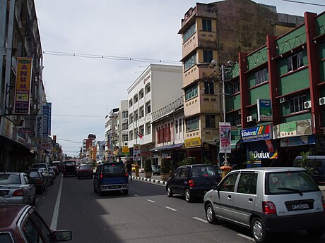
코타바루(말레이어: Kota Bharu, 자위 문자: كوت بهارو)는 말레이시아 클란탄주의 주도로, 말레이시아 반도 지방 북동부와 동부 연안에 위치하며 면적은 394km2, 인구는 425,294명(2005년 기준)이다. 도시 이름은 말레이어로 "새로운 도시" 또는 "새로운 요새"를 뜻한다. 타이와 국경을 접하는 지점에 위치하며 시내에는 모스크와 박물관이 많이 들어서 있다.

기후
| Kota Bharu (1981–2010)의 기후 | |||||||||||||
|---|---|---|---|---|---|---|---|---|---|---|---|---|---|
| 월 | 1월 | 2월 | 3월 | 4월 | 5월 | 6월 | 7월 | 8월 | 9월 | 10월 | 11월 | 12월 | 연간 |
| 역대 최고 기온 °C (°F) | 32.6 (90.7) |
33.0 (91.4) |
34.4 (93.9) |
35.6 (96.1) |
35.8 (96.4) |
34.4 (93.9) |
34.4 (93.9) |
34.4 (93.9) |
34.4 (93.9) |
33.3 (91.9) |
33.3 (91.9) |
32.2 (90.0) |
35.8 (96.4) |
| 일평균 최고 기온 °C (°F) | 29.4 (84.9) |
30.3 (86.5) |
31.4 (88.5) |
32.6 (90.7) |
32.8 (91.0) |
32.7 (90.9) |
32.2 (90.0) |
32.1 (89.8) |
31.8 (89.2) |
31.1 (88.0) |
29.8 (85.6) |
29.1 (84.4) |
31.3 (88.3) |
| 일일 평균 기온 °C (°F) | 26.1 (79.0) |
26.5 (79.7) |
27.3 (81.1) |
28.2 (82.8) |
28.2 (82.8) |
27.9 (82.2) |
27.5 (81.5) |
27.3 (81.1) |
27.0 (80.6) |
26.9 (80.4) |
26.3 (79.3) |
26.1 (79.0) |
27.1 (80.8) |
| 일평균 최저 기온 °C (°F) | 23.3 (73.9) |
23.2 (73.8) |
23.8 (74.8) |
24.4 (75.9) |
24.6 (76.3) |
24.3 (75.7) |
23.9 (75.0) |
23.8 (74.8) |
23.7 (74.7) |
23.7 (74.7) |
23.7 (74.7) |
23.6 (74.5) |
23.8 (74.8) |
| 역대 최저 기온 °C (°F) | 16.7 (62.1) |
17.8 (64.0) |
17.8 (64.0) |
18.3 (64.9) |
21.7 (71.1) |
21.1 (70.0) |
20.6 (69.1) |
21.1 (70.0) |
20.6 (69.1) |
20.6 (69.1) |
18.9 (66.0) |
18.9 (66.0) |
16.7 (62.1) |
| 평균 강우량 mm (인치) | 89 (3.5) |
58 (2.3) |
136 (5.4) |
94 (3.7) |
112 (4.4) |
110 (4.3) |
155 (6.1) |
154 (6.1) |
177 (7.0) |
260 (10.2) |
644 (25.4) |
566 (22.3) |
2,555 (100.6) |
| 평균 강우일수 (≥ 1.0 mm) | 13 | 6 | 9 | 8 | 11 | 11 | 13 | 15 | 17 | 18 | 22 | 20 | 163 |
| 평균 상대 습도 (%) | 84 | 84 | 83 | 82 | 83 | 83 | 83 | 84 | 84 | 86 | 88 | 87 | 84 |
| 평균 월간 일조시간 | 161 | 190 | 207 | 214 | 194 | 186 | 184 | 187 | 187 | 174 | 139 | 130 | 2,153 |
| 출처 1: Ogimet[1] | |||||||||||||
| 출처 2: NOAA,[2] Deutscher Wetterdienst (extremes and humidity)[3] | |||||||||||||
각주
외부 링크
Wikiwand in your browser!
Seamless Wikipedia browsing. On steroids.
Every time you click a link to Wikipedia, Wiktionary or Wikiquote in your browser's search results, it will show the modern Wikiwand interface.
Wikiwand extension is a five stars, simple, with minimum permission required to keep your browsing private, safe and transparent.
