File:Majak_Satellitenkarte.jpg
From Wikipedia, the free encyclopedia
미리 보기 크기: 800 × 509 픽셀 다른 해상도: 320 × 204 픽셀 | 640 × 408 픽셀 | 1,024 × 652 픽셀 | 1,448 × 922 픽셀
원본 파일 (1,448 × 922 픽셀, 파일 크기: 292 KB, MIME 종류: image/jpeg)
| 설명Majak Satellitenkarte.jpg |
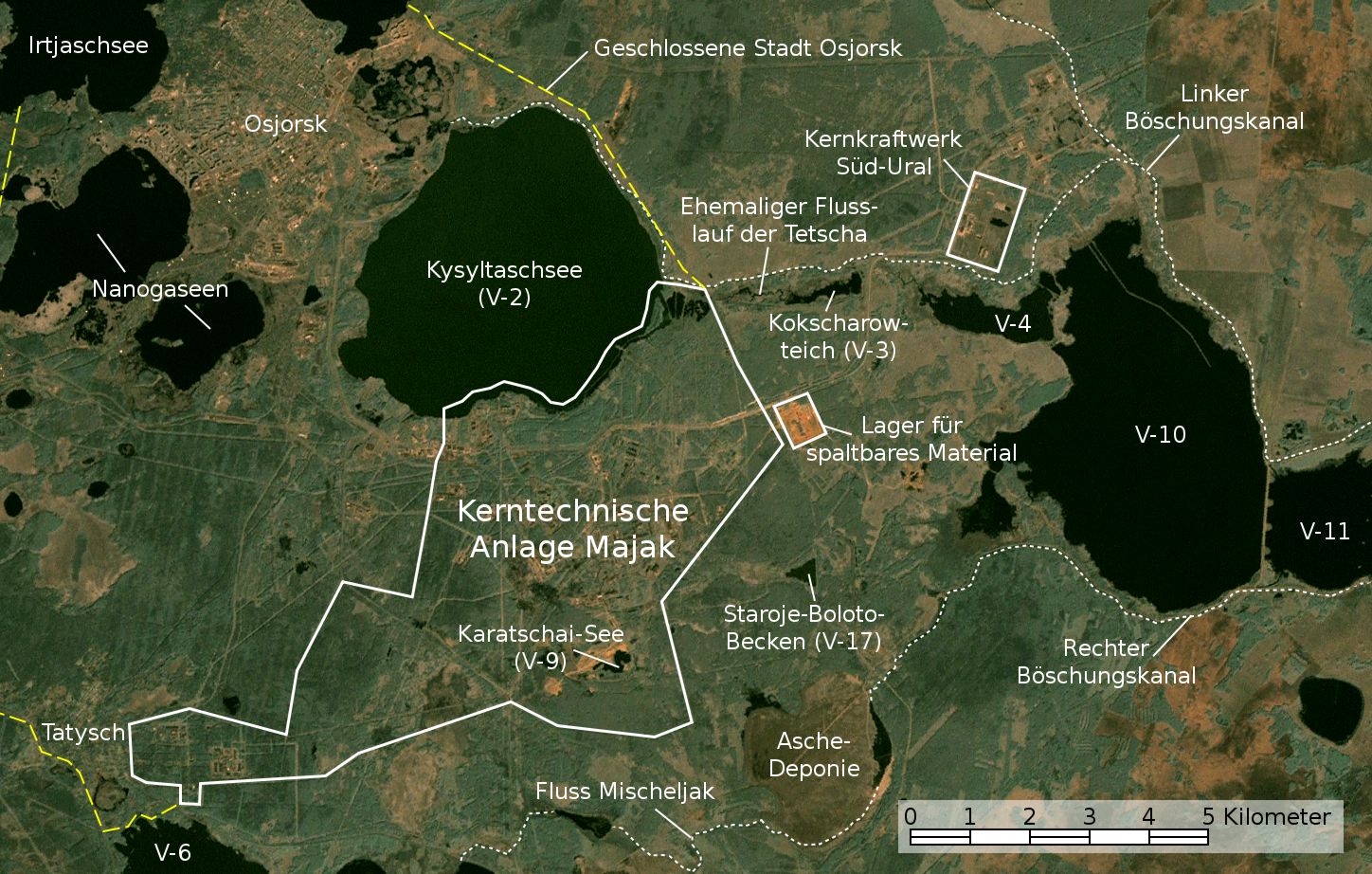
English: Satellite image/map of the Mayak nuclear facility, the closed town of Ozyorsk/Ozersk (Chelyabinsk-65), different lakes and reservoirs, and the South Urals nuclear power plant.
Based on a screenshot from NASA World Wind (Landsat Global Mosaic visual layer), color corrected.
Deutsch: Satellitenfoto/Karte der kerntechnischen Anlage Majak, der geschlossenen Stadt Osjorsk (Tscheljabinsk-65), verschiedenen Seen und Reservoire sowie dem Kernkraftwerk Süd-Ural.
Basierend auf einem Screenshot aus NASA World Wind (Landsat Global Mosaic visual layer), farbkorrigiert. |
|||||||
| 날짜 | ||||||||
| 출처 | NASA World Wind screenshot (Landsat Global Mosaic visual layer) | |||||||
| 저자 | NASA, Jan Rieke (color correction, borders and labels) | |||||||
| 저작권 (이 파일을 인용하기) |
|
|||||||
| 다른 버전 | File:Satellite image map of Mayak.jpg |

| 이 그림은 수정된 그림으로, 원래 그림에서 디지털 변환이 이루어진 그림입니다. 수정 사항 : Farbkorrektur, Bezeichnungen und Grenzen. 수정판 제작자 JanRieke.
|
| 카메라 위치 | 55° 42′ 58.57″ N, 60° 49′ 54.34″ E | 이 지역의 다른 사진을 보기: OpenStreetMap |
|---|
Nennung der Urheber bei Weiterverwendung außerhalb der Wikipedia wäre schön, ist aber nicht erforderlich.
Quellen
Hauptquellen
- Igor Kudrik, Aleksandr Nikitin, Charles Digges, Nils Bøhmer, Vladislav Larin, Vladimir Kuznetsov: The Russian Nuclear Industry – The Need for Reform. Bellona Report Volume 4:2004. Bellona Foundation, S. 47–69, 1. November 2004
- Map of the system of dams and drainage channels at Mayak., in: AMAP Assessment Report: Arctic Pollution Issues, Arctic Monitoring & Assessment Programme, Working Group of the Arctic Council, 1998
- Dmitriy Burmistrov, Mira Kossenko, Richard Wilson: Radioactive Contamination of the Techa River and its Effects. archive copy at the Wayback Machine Technology, Vol. 7, S. 553-575, 2000
Weitere Quellen
Position von V-6
- B. Gusakov, A. Demin, M. Zawadzki, V. Kalinkin, A. Kirsanov, N. Shafrova: Решение экологических проблем Теченского каскада водоемов на ПО "Маяк"., 19. Dezember 2006
Aschedeponie
- A. R. Hutter: Radioactive contamination distribution in the bottom sediments and water of the Mishelyak River[dead link], Journal of Radioanalytical and Nuclear Chemistry, 2001
- O. Aleksandrova: Natural remediation of surface water systems used as deposits of nuclear industry waste by humic substances, Dissertation, Universität Osnabrück, 2009
| 주석 InfoField | 이 이미지에는 주석이 있습니다: 공용에서 주석을 보기 |
설명
이 파일이 나타내는 바에 대한 한 줄 설명을 추가합니다
Image satellite de l'installation nucléaire de Mayak, de la ville fermée d'Ozyorsk/Ozersk (Chelyabinsk-65), de différents lacs et réservoirs et de la centrale nucléaire du sud de l'Oural.
이 파일에 묘사된 항목
다음을 묘사함
14 5 2010
55°42'58.57"N, 60°49'54.34"E
파일 역사
날짜/시간 링크를 클릭하면 해당 시간의 파일을 볼 수 있습니다.
| 날짜/시간 | 섬네일 | 크기 | 사용자 | 설명 | |
|---|---|---|---|---|---|
| 현재 | 2010년 11월 28일 (일) 11:48 | | 1,448 × 922 (292 KB) | JanRieke | Yellow color for closed city borders, slightly reduced brightness |
| 2010년 11월 14일 (일) 09:53 |  | 1,448 × 922 (282 KB) | JanRieke | Included courses of rivers, minor other changes | |
| 2010년 5월 15일 (토) 08:09 |  | 1,448 × 922 (276 KB) | JanRieke | {{Information |Description={{en|1=Satellite image/map of the Mayak nuclear facility, the closed town of Ozyorsk/Ozersk (Chelyabinsk-65), different lakes and reservoirs, and the South Urals nuclear power plant. Based on a screenshot from NASA World Wind (L |
이 파일을 사용하는 문서
이 파일을 사용하는 문서가 없습니다.
이 파일을 사용하고 있는 모든 위키의 문서 목록
다음 위키에서 이 파일을 사용하고 있습니다:
- arz.wikipedia.org에서 이 파일을 사용하고 있는 문서 목록
- ba.wikipedia.org에서 이 파일을 사용하고 있는 문서 목록
- ceb.wikipedia.org에서 이 파일을 사용하고 있는 문서 목록
- da.wikipedia.org에서 이 파일을 사용하고 있는 문서 목록
- de.wikipedia.org에서 이 파일을 사용하고 있는 문서 목록
- de.wikivoyage.org에서 이 파일을 사용하고 있는 문서 목록
- es.wikipedia.org에서 이 파일을 사용하고 있는 문서 목록
- fr.wikipedia.org에서 이 파일을 사용하고 있는 문서 목록
- hu.wikipedia.org에서 이 파일을 사용하고 있는 문서 목록
- ja.wikipedia.org에서 이 파일을 사용하고 있는 문서 목록
- nn.wikipedia.org에서 이 파일을 사용하고 있는 문서 목록
- ru.wikipedia.org에서 이 파일을 사용하고 있는 문서 목록
- sr.wikipedia.org에서 이 파일을 사용하고 있는 문서 목록
- uk.wikipedia.org에서 이 파일을 사용하고 있는 문서 목록
- www.wikidata.org에서 이 파일을 사용하고 있는 문서 목록
메타데이터
이 파일에는 카메라나 스캐너가 파일을 만들거나 디지털화하는 데 사용하기 위해 기록한 부가 정보가 포함되어 있습니다.
프로그램에서 파일을 편집한 경우, 새로 저장한 파일에 일부 부가 정보가 빠질 수 있습니다.
| _error | 0 |
|---|