Tugna:North_Sea_map-en.png
From Wikipedia, the free encyclopedia
Tiddi n azaraskan agi : 479 × 600 iferdisen n tugna. Tibuda nniḍen : 192 × 240 iferdisen n tugna | 383 × 480 iferdisen n tugna | 613 × 768 iferdisen n tugna | 817 × 1 024 iferdisen n tugna | 2 475 × 3 100 iferdisen n tugna.
Afaylu aneṣli (2 475 × 3 100 pixel, tiddi n ufaylu: 3,8 MB/MO, anaw n MIME: image/png)
Afaylu agi yusad seg : Wikimedia Commons. Ahat yeseqdec deg isenfaṛen nniḍen. Aglam-is ɣef asebter n aglam ye beqqeḍ ddaw-agi.
P
Agzul
| AglamNorth Sea map-en.png | |
| Azemz | |
| Aɣbalu |
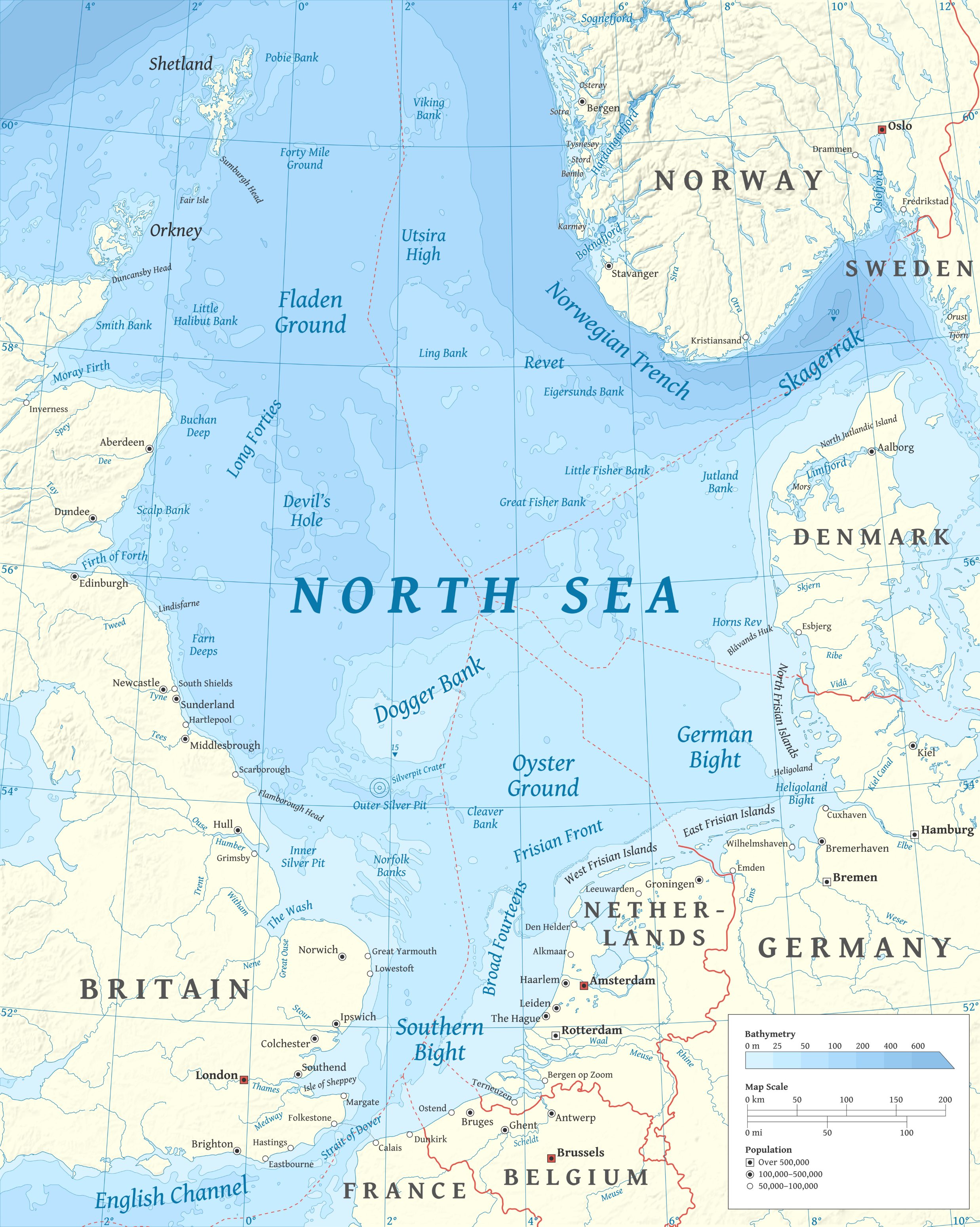
Amahil udmawan using en:GRASS GIS, en:Inkscape and en:GIMP. Data sources:
Map Projection: Universal Transverse Mercator Typeface: Gentium Book Basic from SIL International |
| Ameskar | Halava |
| Autres versions |
  |
Turagt
Moi, en tant que détenteur des droits d’auteur sur cette œuvre, je la publie sous les licences suivantes :
Afaylu-agi yella ddaw n tewtilin n turagt Creative Commons Attribution-Share Alike 3.0 Unported.
- Ɣuṛ-k tilelli:
- i beṭṭu – akken ad tneɣleḍ, ad tzuzreḍ neɣ ad tebḍuḍ amahil-agi
- i uṣeggem – i uṣeggem n umahil
- Ddaw n tiwtilin-agi:
- bab – Yessefk ad d-bedreḍ isem n umeskar aneṣli s wudem yettwammlen sɣuṛ ameskar n umahil neɣ bab n izerfan i k-imudden tasiregt (mačči s wudem yemmalen am akken yettmuddu-yak afus neɣ yeqbel aseqdec-it n umahil).
- bḍut akken yella – Ma tbeddleḍ, teskelteḍ, neɣ tebniḍ ɣef umahil-agi, yessefk ad tezzuzreḍ amahil i d-yeffɣen ɣas ddaw n turagt-nni neɣ turagt icuban ɣuṛ-s.

|
Ɣuṛ-k tasiregt akken ad tneɣleḍ, ad tzuzreḍ neɣ ad tesnifleḍ isemli-agi akken yella di tewtilin n GNU Free Documentation License lqem 1.2 neq yal lqem amaynut i d-yeffɣen sɣuṛ Free Software Foundation, s war abeddel di tgezmiyin, s war aḍris deg usebter amenzu n tdulineɣ s war aḍris deg usebter aneggaru n tduli. Amedya n turagt yedda deg tgezmi ittusemman GNU Free Documentation License.http://www.gnu.org/copyleft/fdl.htmlGFDLGNU Free Documentation Licensetruetrue |
Tzemreḍ ad ferneḍ yiwet seg turagin-agi.
| Annotations InfoField | This image is annotated: View the annotations at Commons |
2149
2258
181
160
2475
3100
Wrongly labled. Weser is actually the Aller flowing into the Weser on the west.
Légendes
Ajoutez en une ligne la description de ce que représente ce fichier
Éléments décrits dans ce fichier
igellem
Valeur sans élément de Wikidata
licence Tafransist
source du fichier Tafransist
6 Tuber 2010
Amazray n ufaylu
Senned ɣef yiwen azmez d usrag iwakken ad ẓṛeḍ afaylu aken yella deg imir nni.
| Azemz/Ssaɛa | Aqmamaḍ | Iseggiwen | Amseqdac | Awennit | |
|---|---|---|---|---|---|
| Lux a | 5 Meɣres 2015 à 17:23 | | 2 475 × 3 100 (3,8 MB/MO) | Tandru7 | {{Information |Description=Map of the North Sea |Source=Wiki Commons |Date=3/5/15 |Author= |Permission= |other_versions= }} |
| 15 Tuber 2010 à 14:48 |  | 2 475 × 3 100 (3,8 MB/MO) | Halava | New place names | |
| 12 Tuber 2010 à 17:34 |  | 2 475 × 3 100 (3,79 MB/MO) | Halava | Some corrections; several new place names | |
| 12 Tuber 2010 à 11:02 |  | 2 475 × 3 100 (3,78 MB/MO) | Halava | Minor corrections; improved legibility; Horns Rev | |
| 10 Tuber 2010 à 08:09 |  | 2 475 × 3 100 (3,72 MB/MO) | Halava | Exclusive economic zones; Heligoland | |
| 9 Tuber 2010 à 09:26 |  | 2 475 × 3 100 (3,64 MB/MO) | Halava | Lindisfarne; Norfolk Banks instead of Wells Bank | |
| 8 Tuber 2010 à 20:27 |  | 2 475 × 3 100 (3,63 MB/MO) | Halava | Outlined Dogger Bank, fixed a typo | |
| 8 Tuber 2010 à 17:04 |  | 2 475 × 3 100 (3,61 MB/MO) | Halava | Several improvements | |
| 6 Tuber 2010 à 10:52 |  | 2 475 × 3 100 (3,37 MB/MO) | Halava | Fixed two typos, switched color model to RGB | |
| 6 Tuber 2010 à 10:09 |  | 2 475 × 3 100 (2,57 MB/MO) | Halava | {{Information |Description={{en|1=Map of the North Sea.}} |Source={{own}} using GRASS GIS, Inkscape and GIMP. Data sources: * Elevation and bathymetry data from NGDC ETOPO1 * Coastlines, rivers and borders from NGDC World Data Bank II * Cities from OpenS |
Aseqdec n ufaylu
Asebter agi teseqdac afaylu agi :
Aseqdec n ufaylu amatu
Iwikiyen-agi-nniḍen seqdacen afaylu-agi:
- Aseqdec ɣef af.wikipedia.org
- Aseqdec ɣef ar.wikipedia.org
- Aseqdec ɣef arz.wikipedia.org
- Aseqdec ɣef ast.wikipedia.org
- Aseqdec ɣef ba.wikipedia.org
- Aseqdec ɣef be-tarask.wikipedia.org
- Aseqdec ɣef bg.wikipedia.org
- Aseqdec ɣef br.wikipedia.org
- Aseqdec ɣef ca.wikipedia.org
- Aseqdec ɣef cs.wikipedia.org
- Aseqdec ɣef cy.wikipedia.org
- Aseqdec ɣef de.wikipedia.org
- Aseqdec ɣef de.wikivoyage.org
- Aseqdec ɣef el.wikipedia.org
- Aseqdec ɣef en.wikipedia.org
- North Sea
- Skagerrak
- SMS Lützow
- HMS King Edward VII
- HMS Marlborough (1912)
- HMS Emperor of India
- HMS Africa (1905)
- Horns Rev
- HMS Britannia (1904)
- Silverpit crater
- Broad Fourteens
- Dogger Bank
- Long Forties
- HMS Hibernia (1905)
- Fisher Bank
- Norwegian trench
- Silver Pit
- Wikipedia:Userboxes/Location
- Operation Wikinger
- HMS Commonwealth
- Northern Patrol
- Raid on Scarborough, Hartlepool and Whitby
- HMS Hindustan (1903)
- User:Buaidh
- Southern Bight
- History of the North Sea
- First Ostend Raid
Wali l’utilisation globale n ufaylu-agi.
Yettwakkes-d seg "https://kab.wikipedia.org/wiki/Tugna:North_Sea_map-en.png"