ფაილი:Aksai_Chin_Sino-Indian_border_map.png
From Wikipedia, the free encyclopedia
თავდაპირველი ფაილი ((624 × 872 პიქსელი, ფაილის ზომა: 102 კბ, MIME ტიპი: image/png))
| ეს ფაილი მდებარეობს Wikimedia Commons სერვერზე. იხილეთ მისი აღწერის გვერდი სრული ინფორმაციისთვის. |
 |
გადასვლა ფაილის გვერდზე |
რეზიუმე


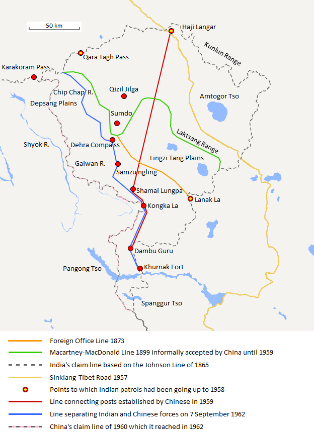
| აღწერაAksai Chin Sino-Indian border map.png |
English: The map shows the Indian and Chinese claims of the border in the Aksai Chin region, the Macartney-MacDonald line, the Foreign Office Line, as well as the progress of Chinese forces as they occupied areas during the Sino-Indian War. |
| თარიღი | |
| წყარო | პირადი ნამუშევარი |
| ავტორი | The Discoverer |
The Macartney-MacDonald line is described as follows: "From the Karakoram Pass the crests of the range run nearly east for about half a degree, and then turn south to a little below the 35th parallel.. Rounding... the source of the Karakash, the line of hills to be followed runs north-east to a point east of Kizil Jilga and from there, in a south-easterly direction, follows the Lak Tsung (Lokzhung) Range until that meets a spur.. which has hitherto been shown on our maps as the eastern boundary of Ladakh.[1]
The Macartney-MacDonald line was never accepted by China, although they informally indicated acceptance on certain occasions:
- Woodman, Dorothy (1969) Himalayan Frontiers: A Political Review of British, Chinese, Indian, and Russian Rivalries, Praeger, p. 102 „The proposed boundary seems never to have been considered in the same form again until Alastair Lamb revived it in 1964.“
- Lamb, Alastair (1965). "Treaties, Maps and the Western Sector of the Sino-Indian Boundary Dispute". The Australian Year Book of International Law. "Unfortunately, the Chinese never replied formally to the note, though they indicated informally on a number of occasions their agreement as to its boundary alignment."
In 1959, Chou confirmed the new Chinese claim line to Nehru.
References: [2] archive copy at the Wayback Machine [3] [4] [5] [6] Map on last page archive copy at the Wayback Machine [7]
ლიცენზია
- თქვენ თავისუფლად შეგიძლიათ:
- ნამუშევრის გაზიარება – ნამუშევრის კოპირება, გავრცელება და გადაცემა.
- შექმნათ დაფუძნებულები – ნამუშევრის შესწორება
- შემდეგი პირობებით:
- მოხსენიება – თქვენ უნდა მიუთითოთ წყაროს შემქმნელი იმ გზით, რომელიც დანიშნა ავტორმა ან საავტორო უფლებების მფლობელმა. მაგრამ არა ისე, თითქოს წყაროს ავტორი მხარს გიჭერთ თქვენ ან დაუჭირა თქვენს მიერ შექმნილ ნაწარმოებს.
- გავრცელება იგივე პირობებეით – თუ თქვენ ცვლით, ან ქმნით ახალ ნაშრომს ამ ნამუშევრის გამოყენებთ, თქვენ გაქვთ უფლება გაავრცელოთ იგი იგივე ან შესაბამისი ლიცენზიით, რომლითაც ვრცელდება წყარო.
Captions
Items portrayed in this file
გამოსახული ობიექტი
some value
copyrighted ინგლისური
27 აგვისტო 2013
source of file ინგლისური
original creation by uploader ინგლისური
media type ინგლისური
image/png
checksum ინგლისური
f6428074bd2a63fcdca4d1c78d6e29848885a399
data size ინგლისური
104131 ბაიტი
872 pixel
624 pixel
ფაილის ისტორია
დააწკაპუნეთ თარიღზე/დროზე ფაილის დასათვალიერებლად, როგორც ის მაშინ გამოიყურებოდა.
| თარიღი/დრო | მინიატიურა | ზომები | მომხმარებელი | შენიშვნა | |
|---|---|---|---|---|---|
| მიმდინარე | 20:06, 7 სექტემბერი 2020 | | 624×872 (102 კბ) | The Discoverer | Removed Tibet-Sinkiang boundary, added label for Amtogor Tso. |
| 02:51, 9 ივნისი 2020 |  | 624×872 (102 კბ) | MarkH21 | Intended change from the last edit (i.e. latest version with "informally" per references in talk discussion) | |
| 02:29, 9 ივნისი 2020 |  | 624×872 (101 კბ) | MarkH21 | Reverted to version as of 00:21, 7 February 2018 (UTC) This was the previous version; the addition of “accepted by China until 1959” was the contested change, not the revert to the original description (the refs are also now dead, but previously said tacit acceptance which isn’t outright acceptance) | |
| 19:37, 23 აპრილი 2018 |  | 624×872 (102 კბ) | The Discoverer | Reverted to version as of 09:10, 13 December 2017 (UTC) The file of 12 December removes a statement that is supported by the source. As per COM:OVERWRITE, "Controversial or contested changes should be uploaded to a separate filename" | |
| 00:21, 7 თებერვალი 2018 |  | 624×872 (101 კბ) | 樂號 | Reverted to version as of 23:05, 12 December 2017 (UTC) | |
| 09:10, 13 დეკემბერი 2017 |  | 624×872 (102 კბ) | The Discoverer | Reverted to version as of 11:07, 19 February 2017 (UTC) The file of 12 December removes a statement that is supported by the source. As per COM:OVERWRITE, "Controversial or contested changes should be uploaded to a separate filename" | |
| 23:05, 12 დეკემბერი 2017 |  | 624×872 (101 კბ) | 樂號 | Macartney–MacDonald Line is only proposed by Britain No official accept made by China | |
| 11:07, 19 თებერვალი 2017 |  | 624×872 (102 კბ) | The Discoverer | Added Karakoram Pass and Kunlun Range | |
| 15:26, 1 აპრილი 2015 |  | 624×872 (59 კბ) | RokerHRO | optipng -o7 -i0 → 40.77% decrease | |
| 15:00, 2 ოქტომბერი 2014 |  | 624×872 (99 კბ) | The Discoverer | Uploaded correct file with scale added. |
ბმულები
ამ ფაილზე ბმული მოცემულია შემდეგ გვერდებზე:
ფაილის გლობალური გამოყენება
ეს ფაილი გამოიყენება შემდეგ ვიკებში:
- გამოყენება ast.wikipedia.org-ში
- გამოყენება as.wikipedia.org-ში
- გამოყენება az.wikipedia.org-ში
- გამოყენება bh.wikipedia.org-ში
- გამოყენება bn.wikipedia.org-ში
- გამოყენება ca.wikipedia.org-ში
- გამოყენება de.wikipedia.org-ში
- გამოყენება en.wikipedia.org-ში
- გამოყენება es.wikipedia.org-ში
- გამოყენება fr.wikipedia.org-ში
- გამოყენება hi.wikipedia.org-ში
- გამოყენება id.wikipedia.org-ში
- გამოყენება it.wikipedia.org-ში
- გამოყენება ja.wikipedia.org-ში
- გამოყენება kn.wikipedia.org-ში
- გამოყენება ko.wikipedia.org-ში
- გამოყენება lv.wikipedia.org-ში
- გამოყენება ml.wikipedia.org-ში
- გამოყენება ms.wikipedia.org-ში
- გამოყენება nl.wikipedia.org-ში
- გამოყენება no.wikipedia.org-ში
- გამოყენება or.wikipedia.org-ში
- გამოყენება pl.wikipedia.org-ში
- გამოყენება pt.wikipedia.org-ში
- გამოყენება ro.wikipedia.org-ში
- გამოყენება ru.wikipedia.org-ში
- გამოყენება ru.wikinews.org-ში
- გამოყენება sr.wikipedia.org-ში
- გამოყენება ta.wikipedia.org-ში
- გამოყენება te.wikipedia.org-ში
- გამოყენება uk.wikipedia.org-ში
- გამოყენება vi.wikipedia.org-ში
იხილეთ, ამ ფაილის გლობალური გამოყენება.
მეტამონაცემები
ეს ფაილი შეიცავს დამატებით ინფორმაციას, რომელიც სავარაუდოდ ამ სურათის შექმნისას გამოყენებულმა ციფრულმა კამერამ ან სკანერმა დაამატა. თუ ფაილის ორიგინალს სახე ეცვალა, ზოგიერთი დეტალი შესაძლოა მოდიფიცირებულ სურათს არ ეხამებოდეს.
| ჰორიზონტალური გაფართოება | 37,8 dpc |
|---|---|
| ვერტიკალური გაფართოება | 37,8 dpc |