ファイル:Caspian_Sea_from_orbit.jpg
ウィキペディア フリーな encyclopedia
このプレビューのサイズ: 471 × 599 ピクセル。 その他の解像度: 188 × 240 ピクセル | 377 × 480 ピクセル | 603 × 768 ピクセル | 804 × 1,024 ピクセル | 1,609 × 2,048 ピクセル | 4,400 × 5,600 ピクセル。
元のファイル (4,400 × 5,600 ピクセル、ファイルサイズ: 3.44メガバイト、MIME タイプ: image/jpeg)
ウィキメディア・コモンズのファイルページにある説明を、以下に表示します。
|
概要
| 解説Caspian Sea from orbit.jpg |
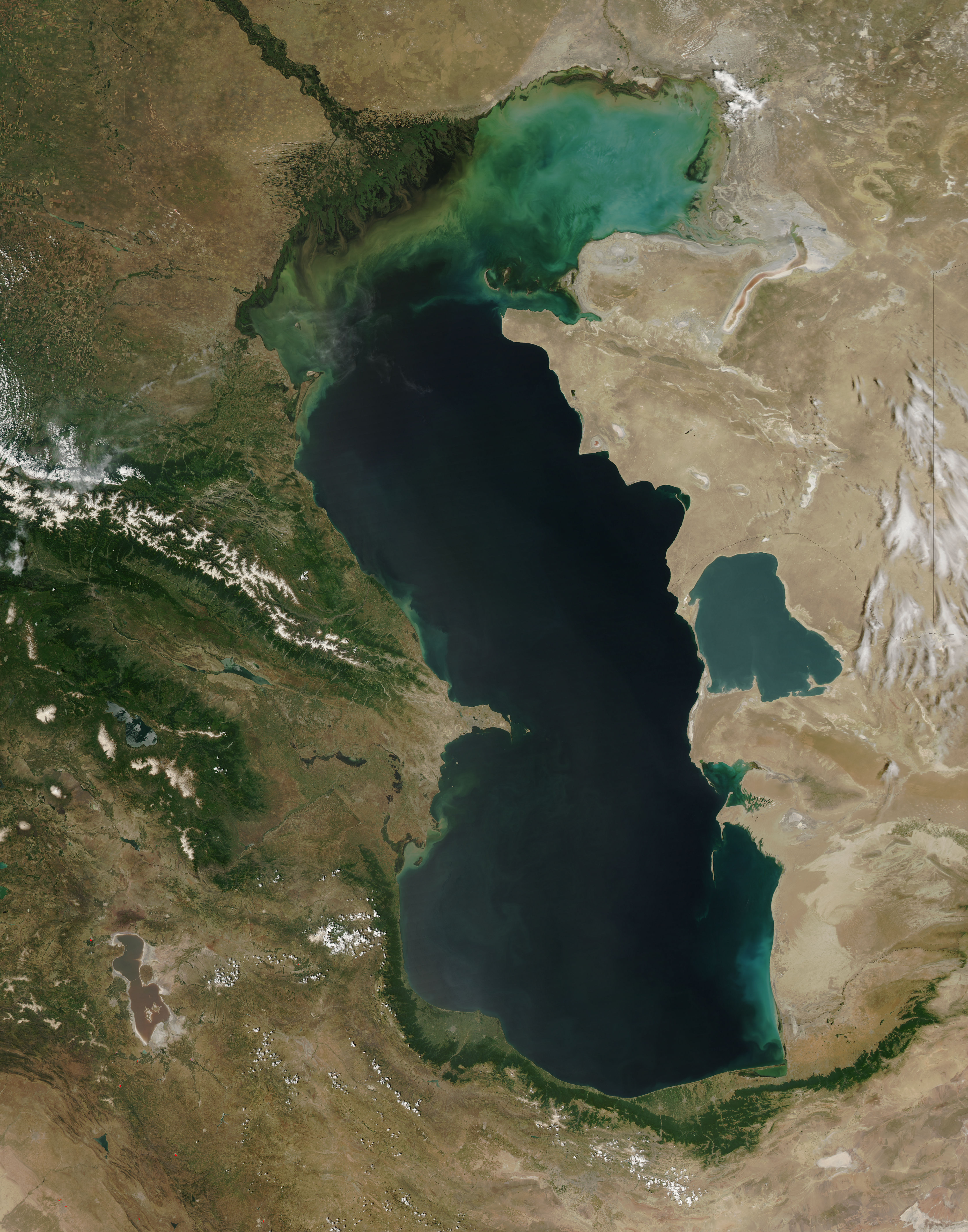
العربية: منظرٌ من مدار الأرض لِبحر قزوين. التعليق الأصلي: كما أوردته وكالة الناسا: ::"القسم الشمالي من بحر قزوين يُعاني من ظاهرةٍ تُعرف باسم التخثث أو إغناء الماء، وهي تلك الحالة التي تتسببُ فيها الأسمدة الزراعيَّة المُنسابة من خِلال مياه الري والأمطار بِنُمو الطحالب في المياه. يُؤدي نُفوق وتحلُّل تلك الطحالب إلى حرمان المياه من الأكسجين، ممَّا يُؤدي بِدوره إلى الإضرار بِالحياة البريَّة بِطبيعة الحال. هذه الصُورة لِبحر قزوين تُظهرُ بعض الدوَّامات الخضراء والزرقاء على مقرُبةٍ من مصب نهر الڤولغا (أعلى الوسط)، ممَّا يدُل على وُجود كميَّةٍ من الطحالب. اللون الأزرق اللامع في القسم الشمالي الشرقي من البحر قد يكون تولَّد نتيجة اختلاط بعض النباتات بِالترسُبات، نظرًا لِأنَّ هذا الموقع هو أكثر المناطق ضُحولةً في البحر.
English: This is a view from orbit of the Caspian Sea as imaged by the MODIS sensor on the Terra satellite. Caption: The original caption from NASA: ::"The northern part of the Caspian Sea is plagued by a process called eutrophication, in which agricultural run-off rich in fertilizers stimulates rampant growth of algae in the water. The death and decay of these algae robs the water of oxygen, with obvious negative consequences for aquatic life. This image of the Caspian Sea shows swirls of green and blue near the mouth of the Volga River (top center), which indicate the presence of algae. The bright blue color of the northeastern part of the sea may be due to a mixture of plant life and sediment, for this is where the sea is most shallow. This image is from the Moderate Resolution Imaging Spectroradiometer (MODIS) on the Terra satellite on June 11, 2003.
Español: El Mar Caspio visto desde la órbita terrestre
فارسی: تصویر ماهوارهای از دریای خزر
Тоҷикӣ: Тасвири Баҳр Каспӣ аз осмон |
| 日付 | |
| 原典 |
http://visibleearth.nasa.gov/view_rec.php?id=5514
|
| 作者 | Jeff Schmaltz, MODIS Rapid Response Team, NASA/GSFC |
| その他のバージョン | このファイルの派生的著作物: Caspian Sea from orbit-NoRedLines.jpg |
|

|
この画像は価値ある画像の方針に基づいて評価され、Satellite images of the Caspian Seaの分野において「コモンズで最も価値のある画像」と判断されています。ここでその推薦を閲覧することができます。 |
ライセンス
| Public domainPublic domainfalsefalse |
| このファイルはアメリカ航空宇宙局(NASA)によって作成されたものです。NASAの著作権の方針では、特記事項が無い場合、NASAの資料はパブリックドメインとなります。 (詳しくはTemplate:PD-USGov、NASAの著作権の方針について(英語)又はジェット推進研究所(JPL)の画像使用に関するガイドライン(英語)をご覧ください。) |
||
 |
注意事項:
|
キャプション
このファイルの内容を1行で記述してください
Caspian Sea from orbit (here the image from MODIS of the Terra satellite on June 11, 2003)
Mar Cáspio.
Kaspisches Meer in der Satellitenansicht (hier das Bild von MODIS vom Satellit Terra am 11. Juni 2003)
XƏZƏR
تصویر ماهوارهای از دریای خزر
11 6 2003
image/jpeg
67680b9374004de157c7612c1187c3ad60f363ee
3,608,474 バイト
5,600 ピクセル
4,400 ピクセル
ファイルの履歴
過去の版のファイルを表示するには、その版の日時をクリックしてください。
| 日付と時刻 | サムネイル | 寸法 | 利用者 | コメント | |
|---|---|---|---|---|---|
| 現在の版 | 2010年6月14日 (月) 09:16 | | 4,400 × 5,600 (3.44メガバイト) | Originalwana | higher res |
| 2005年2月8日 (火) 15:10 |  | 550 × 700 (67キロバイト) | Pixeltoo | Caspian sea by space Nasa |
ファイルの使用状況
以下の 5 ページがこのファイルを使用しています:
グローバルなファイル使用状況
以下に挙げる他のウィキがこの画像を使っています:
- af.wikipedia.org での使用状況
- als.wikipedia.org での使用状況
- am.wikipedia.org での使用状況
- ang.wikipedia.org での使用状況
- an.wikipedia.org での使用状況
- arc.wikipedia.org での使用状況
- ar.wikipedia.org での使用状況
- بحر قزوين
- ويكيبيديا:صور مختارة/الفضاء والكون/نظرة إلى الخلف
- ويكيبيديا:ترشيحات الصور المختارة/بحر قزوين
- ويكيبيديا:صورة اليوم المختارة/ديسمبر 2016
- قالب:صورة اليوم المختارة/2016-12-23
- مستخدم:قائمة أكبر البحيرات والبحار في المجموعة الشمسية
- ويكيبيديا:صورة اليوم المختارة/يوليو 2020
- قالب:صورة اليوم المختارة/2020-07-16
- ويكيبيديا:صورة اليوم المختارة/يوليو 2023
- قالب:صورة اليوم المختارة/2023-07-26
- arz.wikipedia.org での使用状況
- ast.wikipedia.org での使用状況
- as.wikipedia.org での使用状況
- av.wikipedia.org での使用状況
- azb.wikipedia.org での使用状況
- az.wikipedia.org での使用状況
- bat-smg.wikipedia.org での使用状況
- be.wikipedia.org での使用状況
- bew.wikipedia.org での使用状況
- bg.wikipedia.org での使用状況
- bh.wikipedia.org での使用状況
- bn.wikipedia.org での使用状況
- br.wikipedia.org での使用状況
- bs.wikipedia.org での使用状況
- bxr.wikipedia.org での使用状況
- ca.wikipedia.org での使用状況
- ce.wikipedia.org での使用状況
- ckb.wikipedia.org での使用状況
- co.wikipedia.org での使用状況
- cs.wikipedia.org での使用状況
このファイルのグローバル使用状況を表示する。
メタデータ
このファイルには、追加情報があります (おそらく、作成やデジタル化する際に使用したデジタルカメラやスキャナーが追加したものです)。
このファイルが元の状態から変更されている場合、修正されたファイルを完全に反映していない項目がある場合があります。
| _error | 0 |
|---|