Mynd:MPK1-426_Sykes_Picot_Agreement_Map_signed_8_May_1916.jpg
From Wikipedia, the free encyclopedia
Upphafleg skrá (3.322 × 3.225 mynddílar, skráarstærð: 5,7 MB, MIME-gerð: image/jpeg)
Skrá þessi er af Wikimedia Commons, og deilt meðal annarra verkefna og nýtist því þar. Hér fyrir neðan er afrit af skráarsíðunni þar.
Lýsing
| DescriptionMPK1-426 Sykes Picot Agreement Map signed 8 May 1916.jpg |
العربية: خريطة اتفاقية سايكس بيكو تُظهر شرق تُركيا في آسيا وسوريا وغرب بلاد فارس ومناطق نفوذ البريطانيين والفرنسيين المُتَّفق عليها. الجمعية الجغرافية الملكية، 15-1910. وقعها مارك سايكس و فرانسوا جورج بيكو، 8 مايو 1916.
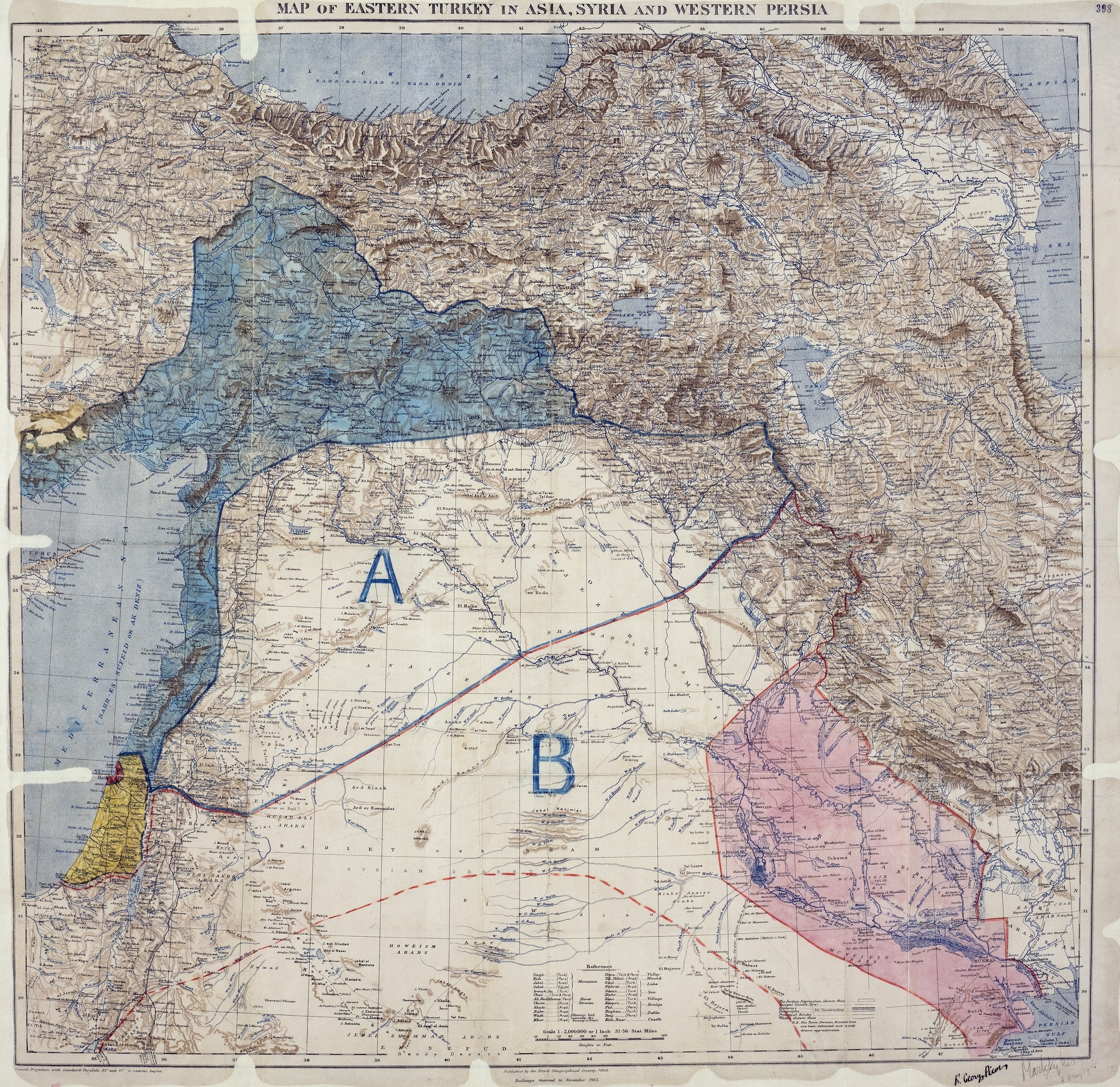
English: Map of showing Eastern Turkey in Asia, Syria and Western Persia, and areas of control and influence agreed between the British and the French. Royal Geographical Society, 1910-15. Signed by Mark Sykes and François Georges-Picot, 8 May 1916.
Français : Carte des Accords Sykes-Picot montrant la Turquie orientale en Asie, Syrie et Perse occidentale, ainsi que les zones de contrôle et d'influence convenues entre la France et le Royaume-Uni. Royal Geographical Society, 1910-15. Signés par Mark Sykes et François Georges-Picot, le 8 Mai 1916.
Kurdî: Nexşeya Peymana Sykes–Picot li Asyayê, rojhilatê Tirkiyeyê, Sûrî û rojavayê Îranê û herêmên di bin serwerî û bandora Brîtanya û Fransa de nîşan dide. Ji aliyê Royal Geographical Society ve, 1910-15 hatiye çêkirin. Ji aliyê Mark Sykes û François Georges-Picot ve hatiye îmzekirin, 8 gulan 1916
Português: Mapa do Acordo Sykes-Picot mostrando a Turquia Oriental na Ásia, a Síria e Pérsia Ocidental e áreas de controle e influência definidas pelos britânicos e os franceses. Real Sociedade Geográfica, 1910-15. Assinado por Mark Sykes e François Georges-Picot, 8 de maio de 1916.
Türkçe: Sykes-Picot Anlaşması kapsamında Fransız ve İngiliz etkisi ve kontrol alanları, Türkiye'nin doğusunda Suriye ve Batı İran bir harita gösterilmektedir.Kraliyet Coğrafya Kurumu, 1910-15. Mark Sykes ve François Georges-Picot imzaları, 8 Mayıs 1916. |
||
| Dagsetning | |||
| Uppruni |
|
||
| Skapari | |||
| Georeferencing | Georeference the map in Wikimaps Warper If inappropriate please set warp_status = skip to hide. | ||
| Aðrar útgáfur |
|
_on_8_May_1916_-_(cropped).jpg)
_on_8_May_1916_(cropped).jpg)
|
Leyfisupplýsingar:
| Public domainPublic domainfalsefalse |
This work is in the public domain in the United States because it was published (or registered with the U.S. Copyright Office) before January 1, 1929.
Public domain works must be out of copyright in both the United States and in the source country of the work in order to be hosted on the Commons. If the work is not a U.S. work, the file must have an additional copyright tag indicating the copyright status in the source country.
Note: This tag should not be used for sound recordings.PD-1923Public domain in the United States//commons.wikimedia.org/wiki/File:MPK1-426_Sykes_Picot_Agreement_Map_signed_8_May_1916.jpg |
| Public domainPublic domainfalsefalse |
This work created by the United Kingdom Government is in the public domain.
This is because it is one of the following:
HMSO has declared that the expiry of Crown Copyrights applies worldwide (ref: HMSO Email Reply) Deutsch ∙ English ∙ Español ∙ français ∙ italiano ∙ Nederlands ∙ polski ∙ português ∙ sicilianu ∙ slovenščina ∙ suomi ∙ Türkçe ∙ македонски ∙ русский ∙ українська ∙ മലയാളം ∙ 한국어 ∙ 日本語 ∙ 简体中文 ∙ 繁體中文 ∙ العربية ∙ +/− |
 |
Captions
Items portrayed in this file
depicts enska
collection enska
UK National Archives enska
7. október 2011
captured with enska
Canon EOS-1Ds Mark III enska
Breytingaskrá skjals
Smelltu á dagsetningu eða tímasetningu til að sjá hvernig hún leit þá út.
| Dagsetning/Tími | Smámynd | Víddir | Notandi | Athugasemd | |
|---|---|---|---|---|---|
| núverandi | 16. maí 2017 kl. 03:58 | | 3.322 × 3.225 (5,7 MB) | PawełMM | Cropped 8 % horizontally and 2 % vertically using CropTool with lossless mode. |
| 12. október 2011 kl. 07:01 |  | 3.600 × 3.293 (5,9 MB) | Gavin.collins |
Skráartenglar
Eftirfarandi síða notar þessa skrá:
Altæk notkun skráar
Eftirfarandi wikar nota einnig þessa skrá:
- Notkun á ar.wikipedia.org
- وعد بلفور
- مراسلات الحسين – مكماهون
- اتفاقية سايكس بيكو
- إمارة شرق الأردن
- بوابة:محتوى متميز
- ويكيبيديا:صور مختارة
- ويكيبيديا:صور مختارة/رسومات وجداول وخرائط
- بوابة:الوطن العربي/صورة مختارة/أرشيف
- ويكيبيديا:صور مختارة/رسومات وجداول وخرائط/خرائط
- بوابة:محتوى متميز/محتويات
- بوابة:محتوى متميز/محتويات/صور مختارة
- بوابة:محتوى متميز/الرئيسية
- الانتداب البريطاني على فلسطين (صك قانوني)
- احتلال معان
- التسوية الإنجليزية الفرنسية المؤقتة 1918
- ويكيبيديا:ترشيحات الصور المختارة/خريطة اتفاقية سايكس بيكو
- ويكيبيديا:صورة اليوم المختارة/أكتوبر 2023
- قالب:صورة اليوم المختارة/2023-10-29
- بوابة:الوطن العربي/صورة مختارة/143
- Notkun á arz.wikipedia.org
- Notkun á ast.wikipedia.org
- Notkun á az.wikipedia.org
- Notkun á bn.wikipedia.org
- Notkun á ca.wikipedia.org
- Notkun á ckb.wikipedia.org
- Notkun á cy.wikipedia.org
- Notkun á de.wikipedia.org
- Notkun á el.wikipedia.org
- Notkun á en.wikipedia.org
- Arabs
- Balfour Declaration
- Emirate of Transjordan
- Sykes–Picot Agreement
- Great Syrian Revolt
- Grease pencil
- Golan Heights
- Mandate for Palestine
- User:Chickstarr404/Gather lists/14627 – Personal History - Desert Gardens by Vincent Sheehan
- Wikipedia:Graphics Lab/Photography workshop/Archive/Jun 2017
- 1918 Anglo-French Modus Vivendi
- Occupation of Ma'an
- User:Free Syrian 200/الثورة السورية الكبرى
- User:Lou Löwe/sandbox
- Rashid Rida during World War I
- User:Sarah SchneiderCH/sandbox2
- User:Falcaorib/Israel and Palestine
- User:Falcaorib/Turkey and Ottoman Empire
- Notkun á eo.wikipedia.org
- Notkun á es.wikipedia.org
- Notkun á fa.wikipedia.org
Skoða frekari altæka notkun þessarar skráar.
Lýsigögn
Þessi skrá inniheldur viðbótarupplýsingar, líklega bætt við úr stafrænu myndavélinni eða skannanum sem notaður var til að búa til eða stafræna hana.
Ef skránni hefur verið breytt frá upprunalegu ástandi gæti verið að sumar upplýsingar endurspegli ekki að fullu breyttu skrána.
| Framleiðandi myndavélar | Canon |
|---|---|
| Tegund myndavélar | Canon EOS-1Ds Mark III |
| Lýsingartími | 1/80 sek (0,0125) |
| F-ljósop | f/20 |
| ISO filmuhraði | 100 |
| Upprunaleg dagsetning | 7. október 2011 kl. 15:19 |
| Brennivídd | 50 mm |
| height | 3.225 |
| width | 3.322 |
| Breidd | 3.600 px |
| Hæð | 3.293 px |
| Bæti á einingu |
|
| Þjöppunar aðferð | Óþjappað |
| Uppbygging mynddíla | RGB |
| Staðsetning myndgagna | 34.880 |
| Stefna | Venjuleg |
| Fjöldi eininga | 3 |
| Fjöldi raða á ræmu | 3.293 |
| Bæti á hverri þjappaðri ræmu | 35.564.400 |
| Lárétt upplausn | 300 pát |
| Lóðrétt upplausn | 300 pát |
| Tilhögun gagna | klumpalegt snið |
| Hugbúnaður | Adobe Photoshop CS4 Windows |
| Dagsetning og tími breytingar | 7. október 2011 kl. 15:41 |
| Lýsingarforrit | Handvirk |
| Exif-útgáfa | 2.21 |
| Dagsetning stafrænnar myndar | 7. október 2011 kl. 15:19 |
| APEX lokhraði | 6,321928 |
| APEX ljósop | 8,643856 |
| APEX lýsingarbjögun | 0 |
| Hámarksvídd ljósops innra byrðis linsu | 1,75 APEX (f/1,83) |
| Mælingahamur | Blettur |
| Leifturljós | Leifturljósið hleypti ekki af, skyldubundin bæling leifturljóss |
| DagurTímiUpprunaleg sekúndubrot | 00 |
| DagurTímiStafrænt sekúndubrot | 00 |
| Hvítvægi | Handstilltur ljóshiti |
| Einkunn (af 5 mögulegum) | 0 |