Mynd:Ligurian_Sea_map.png
From Wikipedia, the free encyclopedia
Það er engin hærri upplausn til.
Ligurian_Sea_map.png (600 × 505 mynddílar, skráarstærð: 145 KB, MIME-gerð: image/png)
Skrá þessi er af Wikimedia Commons, og deilt meðal annarra verkefna og nýtist því þar. Hér fyrir neðan er afrit af skráarsíðunni þar.
Efnisyfirlit
Lýsing
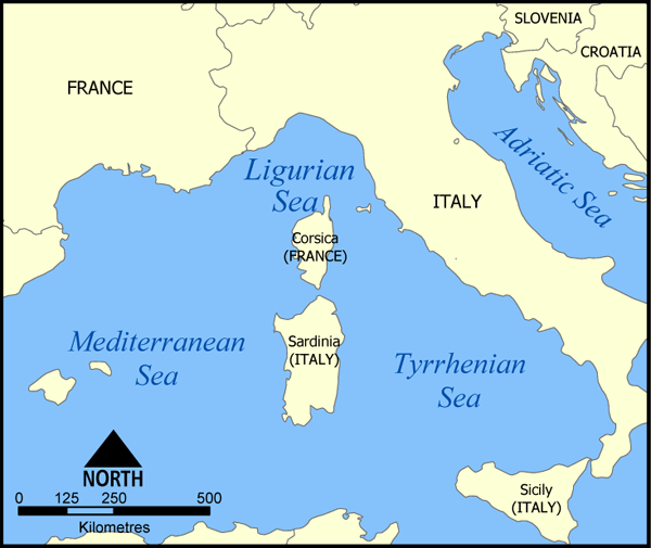
| LýsingLigurian Sea map.png |
A map showing the location of the Ligurian Sea. Created by NormanEinstein, May 20, 2005. |
| Dagsetning | 20. maí 2005 (original upload date) |
| Uppruni | No machine-readable source provided. Own work assumed (based on copyright claims). |
| Höfundarréttarhafi | No machine-readable author provided. NormanEinstein assumed (based on copyright claims). |
| Aðrar útgáfur |
|

Leyfisupplýsingar:
I, the copyright holder of this work, hereby publish it under the following licenses:

|
Gefið er leyfi til að afrita, dreifa og/eða breyta þessu skjali samkvæmt Frjálsa GNU Free Documentation License, útgáfu 1.2 eða nýrri, sem gefið er út af Frjálsu hugbúnaðarstofnuninni með engum breytingum þar á. Afrit af leyfinu er innifalið í kaflanum GNU Free Documentation License.http://www.gnu.org/copyleft/fdl.htmlGFDLGNU Free Documentation Licensetruetrue |
| Þessi skrá er með Creative Commons Tilvísun-DeilaEins 3.0 Óstaðfært notkunarleyfi. | ||
| ||
| This licensing tag was added to this file as part of the GFDL licensing update.http://creativecommons.org/licenses/by-sa/3.0/CC BY-SA 3.0Creative Commons Attribution-Share Alike 3.0truetrue |
Þú mátt velja notkunarleyfi að eigin vali.
Other versions

|
File:Ligurian Sea map hr.svg is a vector version of this file. It should be used in place of this PNG file when not inferior.
File:Ligurian Sea map.png → File:Ligurian Sea map hr.svg
For more information, see Help:SVG.
|
 |
derivative works
Derivative works of this file: Ligurian Sea map-bg.png
Captions
Add a one-line explanation of what this file represents
البحر الليغوري
Items portrayed in this file
depicts enska
copyright status enska
copyrighted enska
20. maí 2005
Breytingaskrá skjals
Smelltu á dagsetningu eða tímasetningu til að sjá hvernig hún leit þá út.
| Dagsetning/Tími | Smámynd | Víddir | Notandi | Athugasemd | |
|---|---|---|---|---|---|
| núverandi | 20. maí 2005 kl. 16:40 | | 600 × 505 (145 KB) | NormanEinstein | A map showing the location of the Ligurian Sea. Created by NormanEinstein, May 20, 2005. {{GFDL-self}} Category:Maps of Seas |
Skráartenglar
Eftirfarandi síða notar þessa skrá:
Altæk notkun skráar
Eftirfarandi wikar nota einnig þessa skrá:
- Notkun á af.wikipedia.org
- Notkun á an.wikipedia.org
- Notkun á ar.wikipedia.org
- Notkun á avk.wikipedia.org
- Notkun á az.wikipedia.org
- Notkun á az.wiktionary.org
- Notkun á be-tarask.wikipedia.org
- Notkun á be.wikipedia.org
- Notkun á bn.wikipedia.org
- Notkun á bs.wikipedia.org
- Notkun á ca.wikipedia.org
- Notkun á ckb.wikipedia.org
- Notkun á cs.wikipedia.org
- Notkun á da.wikipedia.org
- Notkun á en.wikipedia.org
- Notkun á es.wikipedia.org
- Notkun á fa.wikipedia.org
- Notkun á fi.wikipedia.org
- Notkun á frr.wikipedia.org
- Notkun á fr.wikipedia.org
- Notkun á gl.wikipedia.org
- Notkun á hr.wikipedia.org
- Notkun á ia.wikipedia.org
- Notkun á id.wikipedia.org
- Notkun á ilo.wikipedia.org
- Notkun á it.wikipedia.org
- Notkun á ja.wikipedia.org
- Notkun á ka.wiktionary.org
- Notkun á ko.wikipedia.org
- Notkun á la.wikipedia.org
- Notkun á lij.wikipedia.org
- Notkun á li.wikipedia.org
Skoða frekari altæka notkun þessarar skráar.