Papeles:MerguiArchipelagoMap.png
From Wikipedia, the free encyclopedia
Kadakkel daytoy a panagipadas: 322 × 598 dagiti piksel. Sabali kadagiti resolusion: 129 × 240 dagiti piksel | 258 × 480 dagiti piksel | 973 × 1,808 dagiti piksel.
Kasisigud a papeles (973 × 1,808 dagiti piksel, kadakkel ti papeles: 61 KB, kita ti MIME: image/png)
| Daytoy ket papeles a nagtaud manipud idiay Wikimedia Commons. Ti pakaammo manipud iti bukodna a deskripsion a panid idiay ket naiparang dita baba. Ti Commons ket repositorio dagiti nawaya a nalisensiaan a midia. Mabalinmo ti tumulong. |
Pakabuklan
| DeskripsionMerguiArchipelagoMap.png |
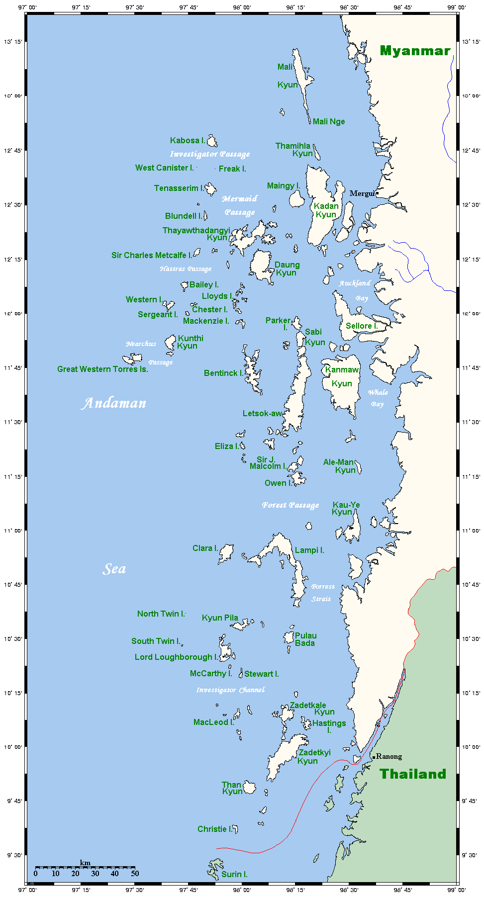
Map of the Mergui Archipelago in Myanmar. This map's source is here, with the uploader's modifications, and the GMT homepage says that the tools are released under the GNU General Public License. There is a somewhat bigger map of this area, showing places farther north and south. This is not on Wikipedia, but leave a message at my talk page if you would like such a thing, and likewise if you know any further information that ought to go on this map. |
| Petsa | 14 Mayo 2006 (original upload date) |
| Taudan | Transferred from en.wikipedia to Commons. |
| Mannurat | Kelisi at English Wikipedia |

|
This map image could be re-created using vector graphics as an SVG file. This has several advantages; see Commons:Media for cleanup for more information. If an SVG form of this image is available, please upload it and afterwards replace this template with
{{vector version available|new image name}}.
It is recommended to name the SVG file “MerguiArchipelagoMap.svg”—then the template Vector version available (or Vva) does not need the new image name parameter. |
Lisensia
Ni Kelisi from en.wikipedia.org, ti agtengtengel ti karbengan ti kopia iti daytoy nga obra, ket agipablaak babaen ti sumaganad a lisensia:
| Daytoy a papeles ket nalisensiaan babaen ti Creative Commons Attribution-Share Alike 3.0 Unported a lisensia. Subject to disclaimers. | ||
| Pammadayaw: Kelisi from en.wikipedia.org | ||
| ||
| Daytoy nga etiketa ti panaglisensia ket nainayon iti daytoy a papeles a kas paset iti GFDL a panagbabaro ti panaglisensia.http://creativecommons.org/licenses/by-sa/3.0/CC BY-SA 3.0Creative Commons Attribution-Share Alike 3.0truetrue |

|
Maited ti pammalubos ti agkopia, agiwaras ken/wenno mangbaliw iti daytoy a dokumento babaen ti termino iti GNU Free Documentation License, Bersion 1.2 wenno ti ania man a kinaudi a bersion babaen ti Free Software Foundation; nga awan dagiti Sabsabali a Paset, awan dagiti Sanguan nga Aklub a Teksto, ken dagiti Likudan nga Aklub a Teksto. Ti kopia ti lisensia ket nairaman iti paset a natituluan iti GNU Free Documentation License. Subject to disclaimers.http://www.gnu.org/copyleft/fdl.htmlGFDLGNU Free Documentation Licensetruetrue |
Kasisigud a listaan pang-ipan
The original description page was here. All following user names refer to en.wikipedia.
- 2006-05-14 20:32 Kelisi 973×1808×8 (62506 bytes) Map of the Mergui Archipelago in Myanmar. This map's source is [http://www.aquarius.geomar.de/omc/make_map.html here], with the uploader's modifications, and the [http://gmt.soest.hawaii.edu/ GMT homepage] says that the tools are released under the GNU Ge
Captions
Add a one-line explanation of what this file represents
Items portrayed in this file
mangipresenta
copyright status English
copyrighted English
Pakasaritaan ti papeles
Pinduten iti petsa/oras tapno makita ti papeles a kas naiparang iti dayta a panawen.
| Petsa/Oras | Bassit a ladawan | Dagiti rukod | Agar-aramat | Komentario | |
|---|---|---|---|---|---|
| agdama | 23:20, 1 Mayo 2007 | | 973 × 1,808 (61 KB) | Ppntori | {{Information |Description=Map of the Mergui Archipelago in Myanmar. This map's source is [http://www.aquarius.geomar.de/omc/make_map.html here], with the uploader's modifications, and the [http://gmt.soest.hawaii.edu/ GMT homepage] says that the tools ar |
Panagusar iti papeles
Ti sumaganad a panid ket agus-usar iti daytoy a papeles:
Global a panagusar ti papeles
Dagiti sumaganad a wiki ket agus-usar iti daytoy a papeles:
- Panagusar idiay ar.wikipedia.org
- Panagusar idiay arz.wikipedia.org
- Panagusar idiay ban.wikipedia.org
- Panagusar idiay bcl.wikipedia.org
- Panagusar idiay bg.wikipedia.org
- Panagusar idiay bh.wikipedia.org
- Panagusar idiay bn.wikipedia.org
- Panagusar idiay bs.wikipedia.org
- Panagusar idiay ca.wikipedia.org
- Panagusar idiay ckb.wikipedia.org
- Panagusar idiay cy.wikipedia.org
- Panagusar idiay de.wikipedia.org
- Panagusar idiay en.wikipedia.org
- Panagusar idiay es.wikipedia.org
- Panagusar idiay fa.wikipedia.org
- Panagusar idiay fi.wikipedia.org
- Panagusar idiay fr.wikipedia.org
- Panagusar idiay fy.wikipedia.org
- Panagusar idiay ga.wikipedia.org
- Panagusar idiay hi.wikipedia.org
- Panagusar idiay hu.wikipedia.org
- Panagusar idiay ia.wikipedia.org
- Panagusar idiay id.wikipedia.org
- Panagusar idiay incubator.wikimedia.org
- Panagusar idiay io.wikipedia.org
- Panagusar idiay it.wikipedia.org
- Panagusar idiay ja.wikipedia.org
- Panagusar idiay jv.wikipedia.org
- Panagusar idiay kk.wikipedia.org
- Panagusar idiay km.wikipedia.org
- Panagusar idiay kn.wikipedia.org
- Panagusar idiay ko.wikipedia.org
- Panagusar idiay lt.wikipedia.org
- Panagusar idiay min.wikipedia.org
- Panagusar idiay mk.wikipedia.org
Kitaen ti adu pay a global a panagusar iti daytoy a papeles.
Naala manipud iti "https://ilo.wikipedia.org/wiki/Papeles:MerguiArchipelagoMap.png"