File:East-Hem_323bc.jpg
From Wikipedia, the free encyclopedia
Dimension de iste previsualisation: 800 × 470 pixels.Altere resolutiones: 320 × 188 pixels | 640 × 376 pixels | 1 024 × 601 pixels | 1 280 × 752 pixels | 3 240 × 1 903 pixels.
File original (3 240 × 1 903 pixels, dimension del file: 712 KB, typo MIME: image/jpeg)
Iste file proveni de Wikimedia Commons e pote esser usate per altere projectos. Le description de su pagina de description ibi es monstrate in basso.

|
This historical map image could be re-created using vector graphics as an SVG file. This has several advantages; see Commons:Media for cleanup for more information. If an SVG form of this image is available, please upload it and afterwards replace this template with
{{vector version available|new image name}}.
It is recommended to name the SVG file “East-Hem 323bc.svg”—then the template Vector version available (or Vva) does not need the new image name parameter. |
 | This historical map image was uploaded in the JPEG format even though it consists of non-photographic data. This information could be stored more efficiently or accurately in the PNG or SVG format. If possible, please upload a PNG or SVG version of this image without compression artifacts, derived from a non-JPEG source (or with existing artifacts removed). After doing so, please tag the JPEG version with {{Superseded|NewImage.ext}} and remove this tag. This tag should not be applied to photographs or scans. If this image is a diagram or other image suitable for vectorisation, please tag this image with {{Convert to SVG}} instead of {{BadJPEG}}. If not suitable for vectorisation, use {{Convert to PNG}}. For more information, see {{BadJPEG}}. |  |
| DescriptionEast-Hem 323bc.jpg |
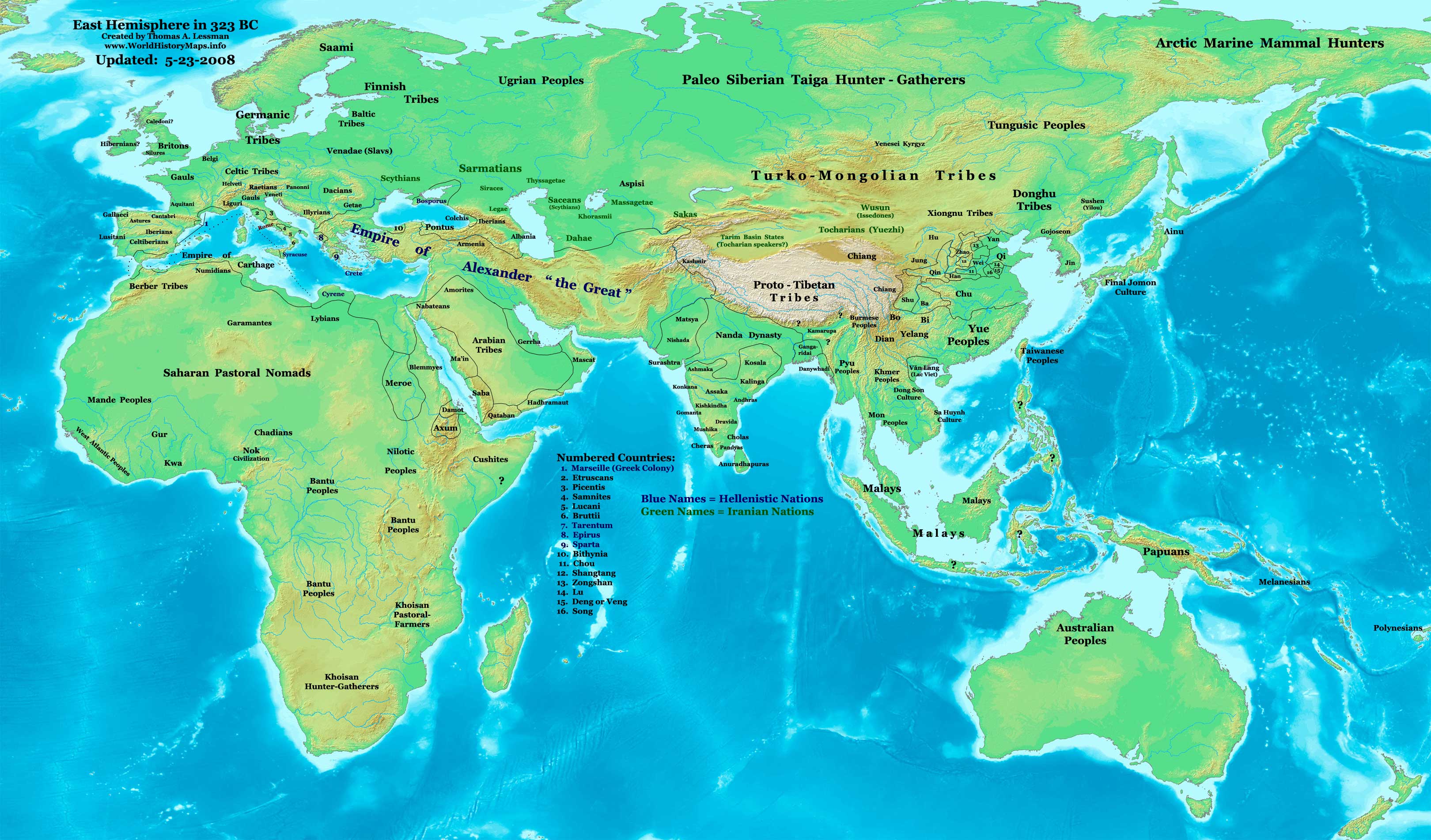
English: Eastern Hemisphere in 323 BC, at the death of Alexander the Great. |
| Origine | Obra proprie (For reference information, see below) |
| Autor | Thomas Lessman (Contact!) |
| Permission (Reuso de iste file) |
Io, titular del derecto de autor sur iste obra, declara de publicar lo sub le sequente licentia: Iste file es disponibile sub le licentia Creative Commons Attribution-CompartiSimile 3.0 Non localisate.
|
Contento
Map Summary
Original Source URL: http://www.thomaslessman.com/History/images/East-Hem_323bc.jpg.
This map of the Eastern Hemisphere in 323 BC was created by Thomas Lessman, based on information from the sources listed below. This map is free for educational use (see Permission info above). When using this map, please mention that it is available for free at www.WorldHistoryMaps.info.
Map Source References
- Remember, sources often conflict with each other. This map is only as accurate as the information that is available to me.
- To report any errors or to help further this work, please use the Corrections page, or email Thomas Lessman at talessman@yis.us
References for information contained in this map:
Empire of Alexander the Great information is derived from:
- The DK Atlas of World History, 2000 Edition; map of Alexander's Empire and successors; (Pg. 224)
- Wikimedia's map of The Empire of Alexander the Great uploaded by User talk:Captain Blood
- Wikipedia's article about Alexander the Great
I - European Information:
- Roman Republic borders are derived from The DK Atlas of World History, 2000 Edition; Pg. 178; Map of Italy in 240 BCE (also shows Roman borders in 300 BCE).
II - Asian Information:
- Chinese Area borders are derived from this map of The Contending States Boundries c. 350 BC, available on Huhai.net.
- Indian Kingdoms locations are derived from Wikimedia's map of Epic India.
- Gangaridai Note: the borders depicted for Gangaridai are not shown on any maps I've seen, they are described rather vaguely in the sources below:
- This article about The Origins of the Ganga Dynasty - A New Insight archive copy at the Wayback Machine by Dr. Harihar Kanungo; (Pg 25, section a).
- This article from Missouri Southern State University about Gangaridae in Megasthenes' Indica archive copy at the Wayback Machine; (Section 37).
- The History of Bengal website, which contains extensive information on an archeological site called Chandraketugarh, which may be the lost city of Ganga (the capital of Gangaridai).
- Nanda Dynasty borders are derived from:
- The DK Atlas of World History, 2000 Edition; Map of The Nanda and Mauryan Empires 365-181 BCE; (Pg. 241)
- Văn Lang borders are derived from:
- Wikimedia's map of Van Lang, created by User:Briangotts.
- Wikipedia's articles about Văn Lang and the Hồng Bàng Dynasty.
III - African Information and info for fringe areas like Africa, Australia, Siberia, etc. derive from:
- The DK Atlas of World History, 2000 Edition; map of The development of complex societies in Africa; (Page 160)
- Wikimedia's map of the World 323 BCE, created by User:Briangotts, and
- Wikimedia's map of the World in 300 BCE, created by User:Javierfv1212.
Note: Much of the information in this map was cross-checked with Bruce Gordon's Regnal Chronologies.
Other Maps by Thomas Lessman
| Maps of the eastern hemisphere showing history
Bold dates are available on Wikimedia or Wikipedia. | ||
| Primeval | ||
| Ancient
|
·| 600 BC | 550 BC | 527 BC | 500 BC |
400 BC | ·| 1 AD | 50 AD | 100 AD | 200 AD | 300 AD | | |
| Medieval |
·| 500 AD | 565 AD | 600 AD | 700 AD | | |
| Modern |
·| 1500 AD | · * For historical maps of the whole world, | |
| history links talk edit view | ||
Registro de incargamento original
- 2007-12-21 15:09 Talessman 3240×1903×8 (717376 bytes) Corrected info for Far eastern peoples, more info for Africa and Europe
- 2007-11-21 19:34 Talessman 3240×1903×8 (697847 bytes) Added info on lesser-known cultures. Also changed text color of Helenistic states to Blue, of Iranian peoples to green, and added names of smaller nations (numbered legend).
- 2007-11-06 22:20 Talessman 3240×1903×8 (689151 bytes) Corrected borders in Sudan (Meroe) and Arabia, added info for Japan, Indonesia, etc.
- 2007-10-02 17:49 Talessman 2880×1692×8 (546378 bytes) Author: Thomas A. Lessman. Source URL: http://www.ThomasLessman.com/History/images/East-Hem_323bc.jpg. Image was created by me (Thomas Lessman) based on historical information located on Wikipedia, as well as information from maps located in Wikipedia and
- 2007-09-12 21:35 Talessman 2880×1692×8 (514268 bytes) Author: Thomas A. Lessman. Source URL: http://www.ThomasLessman.com/History/images/East-Hem_323bc.jpg. Image was created by me (Thomas Lessman) based on historical information located on Wikipedia, as well as information from maps located in Wikipedia and
Legendas
Objectos representate in iste file
representa
Alcun valor sin elemento Wikidata
copyright status anglese
copyrighted anglese
source of file anglese
original creation by uploader anglese
media type anglese
image/jpeg
Historia del file
Clicca sur un data/hora pro vider le file como appareva a ille tempore.
| Data/Hora | Miniatura | Dimensiones | Usator | Commento | |
|---|---|---|---|---|---|
| actual | 15:08, 26 februario 2011 | | 3 240 × 1 903 (712 KB) | Martin H. | Reverted to version as of 07:37, 23 May 2008, downscaling |
| 11:59, 24 februario 2011 |  | 800 × 470 (86 KB) | Prince of Nothing05 | Armenia wasn't part of Alexander the Greta's Empire | |
| 07:37, 23 maio 2008 |  | 3 240 × 1 903 (712 KB) | Talessman | Corrected borders of Rome, Carthage, Alexander's Empire, Nanda Empire, and China. Also corrected placement of Tocharians, added more info for Europe, India, Africa, and East Asia. | |
| 14:53, 9 maio 2008 |  | 3 240 × 1 903 (708 KB) | Talessman | {{Information |Description='''Eastern Hemisphere in 500 BC'''. |Source=self-made (For reference information, see below) |Author=Thomas Lessman (Contact!) |Permission={{self|cc-by-sa-3.0}} }} |
Uso de iste file
Il non ha paginas que usa iste file.
Uso global de iste file
Le altere wikis sequente usa iste imagine:
- Uso in ar.wikipedia.org
- Uso in azb.wikipedia.org
- Uso in de.wikipedia.org
- Uso in el.wikipedia.org
- Uso in en.wikipedia.org
- Uso in en.wikibooks.org
- Uso in es.wikipedia.org
- Uso in fa.wikipedia.org
- Uso in it.wikipedia.org
- Uso in lv.wikipedia.org
- Uso in mk.wikipedia.org
- Uso in ru.wikipedia.org
- Uso in sh.wikipedia.org
- Uso in sl.wikipedia.org
- Uso in sq.wikipedia.org
- Uso in su.wikipedia.org
- Uso in ta.wikipedia.org
- Uso in vi.wikipedia.org
- Uso in zh.wikibooks.org