Պատկեր:Colonias_europea_en_América_siglo_XVI-XVIII.png
From Wikipedia, the free encyclopedia
Սկզբնական նիշք (536 × 618 փիքսել, նիշքի չափը՝ 11 ԿԲ, MIME-տեսակը՝ image/png)
Այս նիշքը տեղադրված է Վիքիպահեստում է և այն կարող է օգտագործվել այլ նախագծերի կողմից։ Վիքիպահեստում նիշքի մասին տեղեկությունների հիմնական մասը ներկայացված է ստորև։
Բովանդակություն
Ամփոփում

|
This historical map image could be re-created using vector graphics as an SVG file. This has several advantages; see Commons:Media for cleanup for more information. If an SVG form of this image is available, please upload it and afterwards replace this template with
{{vector version available|new image name}}.
It is recommended to name the SVG file “Colonias europea en América siglo XVI-XVIII.svg”—then the template Vector version available (or Vva) does not need the new image name parameter. |
Արտոնագրում
| ՆկարագրումColonias europea en América siglo XVI-XVIII.png |
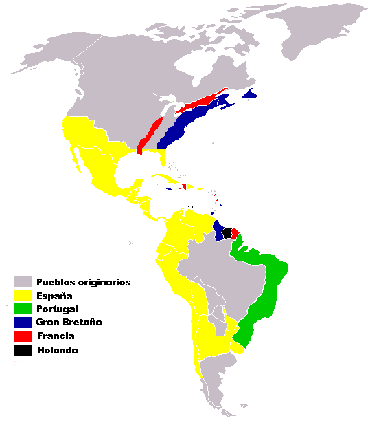
English: Map of European colonies in the Americas in the 16th through 18th centuries
Español: Mapa de colonias europeas en América, siglos XVI-XVIII |
||
| Թվական | |||
| Աղբյուր | Mapa de Hispanic America (made from Image:BlankMap-World.png) | ||
| Հեղինակ | Pepe Robles | ||
| Իրավունքներ (Նիշքի վերաօգտագործումը) |
own work | ||
| Այլ մեկնակերպներ |
|
Español
Mapa de Colonias europeas en America siglos XVI-XVII-XVIII (hecho de Image:BlankMap-World.png). El mapa tiene como finalidad hacer visible a grandes trazos el alcance territorial de la presencia colonial europea en América, sobre todo en los siglos XVI y XVIII. pero enberdad fue en el siglo v:
- Las posesiones españolas se extendían desde el cabo de hornos en el sur del continente hasta las montañas de Nevada en norteamerica, atravesando toda centroamérica y alcanzando hasta
Florida. Ciertas comunidades indígenas fueron respetadas por su bravura y la única relación era comercial.
- Las posesiones portuguesas están tomadas de las zonas que ocuparon: toda la franja costera más la zona de las misiones. No se incluye la región del Mato Grosso y la Amazonia.
- Las posesiones francesas son Luisiana y Quebec, en Norte América, y La Guayana Fr., Haití y otras islas en el Caribe y Sur América.
- Las posesiones británicas son las treces colonias más las posesiones en lo que luego sería Canadá, más algunas islas en el Caribe y la Guayana británica.
- Las posesiones holandesas son la Guayana holandesa y algunas islas en el Caribe.
No se incluyen pequeñas posesiones coloniales de Rusia, Escocia, Gales, ni Curlandia. Tampoco se incluyen los estados independientes afrobrasileños en Los Palmares, ni las Misiones Jesuíticas que mantuvieron una organización comunitaria autónoma cristiano-guaraní. Tampoco se incluyen varias islas del Caribe que no fueron colonizadas o que estuvieron en poder de piratas.
Cristobal Colon murió de 55 años de edad...el fue a America pero sin saber de que era un nuevo continente, el pensaba que eran las Indias para luego que muriera... Americo vespucio dio a conocer un documento de que ese era un nuevo lugar y que no era las Indias, como se creía
Արտոնագրում
| Public domainPublic domainfalsefalse |
| I, the copyright holder of this work, release this work into the public domain. This applies worldwide. In some countries this may not be legally possible; if so: I grant anyone the right to use this work for any purpose, without any conditions, unless such conditions are required by law. |
Captions
2006
image/png
checksum անգլերեն
e446229d899e4494b4b91b0cbe69d074c442d21b
data size անգլերեն
11 328 Բայթ
618 փիքսել
536 փիքսել
Նիշքի պատմություն
Մատնահարեք օրվան/ժամին՝ նիշքի այդ պահին տեսքը դիտելու համար։
| Օր/Ժամ | Մանրապատկեր | Օբյեկտի չափը | Մասնակից | Մեկնաբանություն | |
|---|---|---|---|---|---|
| ընթացիկ | 11:03, 12 Հուլիսի 2019 | | 536 × 618 (11 ԿԲ) | Prosfilaes | Reverted to version as of 01:37, 15 December 2007 (UTC) |
| 18:02, 8 Հուլիսի 2019 |  | 536 × 618 (25 ԿԲ) | Thylacinus cynocephalus | Removed anacronistic borders | |
| 01:37, 15 Դեկտեմբերի 2007 |  | 536 × 618 (11 ԿԲ) | Kordas | fixing image | |
| 23:13, 10 Սեպտեմբերի 2006 |  | 536 × 618 (12 ԿԲ) | Roblespepe | == Español == Mapa de '''Colonias europeas en America siglos XVI-XVII''' (hecho de Image:BlankMap-World.png). == Licensing == America {{Information |Description=Mapa de Colonias europeas en America siglos XVI-XVII |Sour | |
| 23:12, 10 Սեպտեմբերի 2006 |  | 536 × 618 (13 ԿԲ) | Roblespepe | == Español == Mapa de '''Colonias europeas en America siglos XVI-XVII''' (hecho de Image:BlankMap-World.png). == Licensing == America {{Information |Description=Mapa de Colonias europeas en America siglos XVI-XVII |Sour | |
| 23:08, 10 Սեպտեմբերի 2006 |  | 536 × 618 (13 ԿԲ) | Roblespepe | == Español == Mapa de '''Colonias europeas en America siglos XVI-XVII''' (hecho de Image:BlankMap-World.png). == Licensing == America {{Information |Description=Mapa de Colonias europeas en America siglos XVI-XVII |Sour |
Նիշքի օգտագործում
Հետևյալ էջը հղվում է այս նիշքին՝
Նիշքի համընդհանուր օգտագործում
Հետևյալ այլ վիքիները օգտագործում են այս նիշքը՝
- Օգտագործումը an.wikipedia.org կայքում
- Օգտագործումը ast.wikipedia.org կայքում
- Օգտագործումը be.wikipedia.org կայքում
- Օգտագործումը ca.wikipedia.org կայքում
- Օգտագործումը en.wikipedia.org կայքում
- Օգտագործումը es.wikipedia.org կայքում
- Օգտագործումը fa.wikipedia.org կայքում
- Օգտագործումը id.wikipedia.org կայքում
- Օգտագործումը ka.wikipedia.org կայքում
- Օգտագործումը pt.wikipedia.org կայքում
- Օգտագործումը qu.wikipedia.org կայքում
- Օգտագործումը ru.wikipedia.org կայքում
- Օգտագործումը ta.wikipedia.org կայքում
- Օգտագործումը ta.wiktionary.org կայքում
- Օգտագործումը tr.wikipedia.org կայքում
- Օգտագործումը uk.wikipedia.org կայքում
- Օգտագործումը vi.wikipedia.org կայքում