Պատկեր:20110419_bridge_Akhurian_River_Ani_Turkey.jpg
From Wikipedia, the free encyclopedia
Նախադիտման չափ՝ 800 × 532 պիքսել։ Այլ թույլտվությաններ: 320 × 213 պիքսել | 640 × 426 պիքսել | 1024 × 681 պիքսել | 1280 × 852 պիքսել | 2560 × 1703 պիքսել | 4256 × 2832 պիքսել.
Սկզբնական նիշք (4256 × 2832 փիքսել, նիշքի չափը՝ 12,01 ՄԲ, MIME-տեսակը՝ image/jpeg)
Այս նիշքը տեղադրված է Վիքիպահեստում է և այն կարող է օգտագործվել այլ նախագծերի կողմից։ Վիքիպահեստում նիշքի մասին տեղեկությունների հիմնական մասը ներկայացված է ստորև։
Ամփոփում
| Նկարագրում20110419 bridge Akhurian River Ani Turkey.jpg |
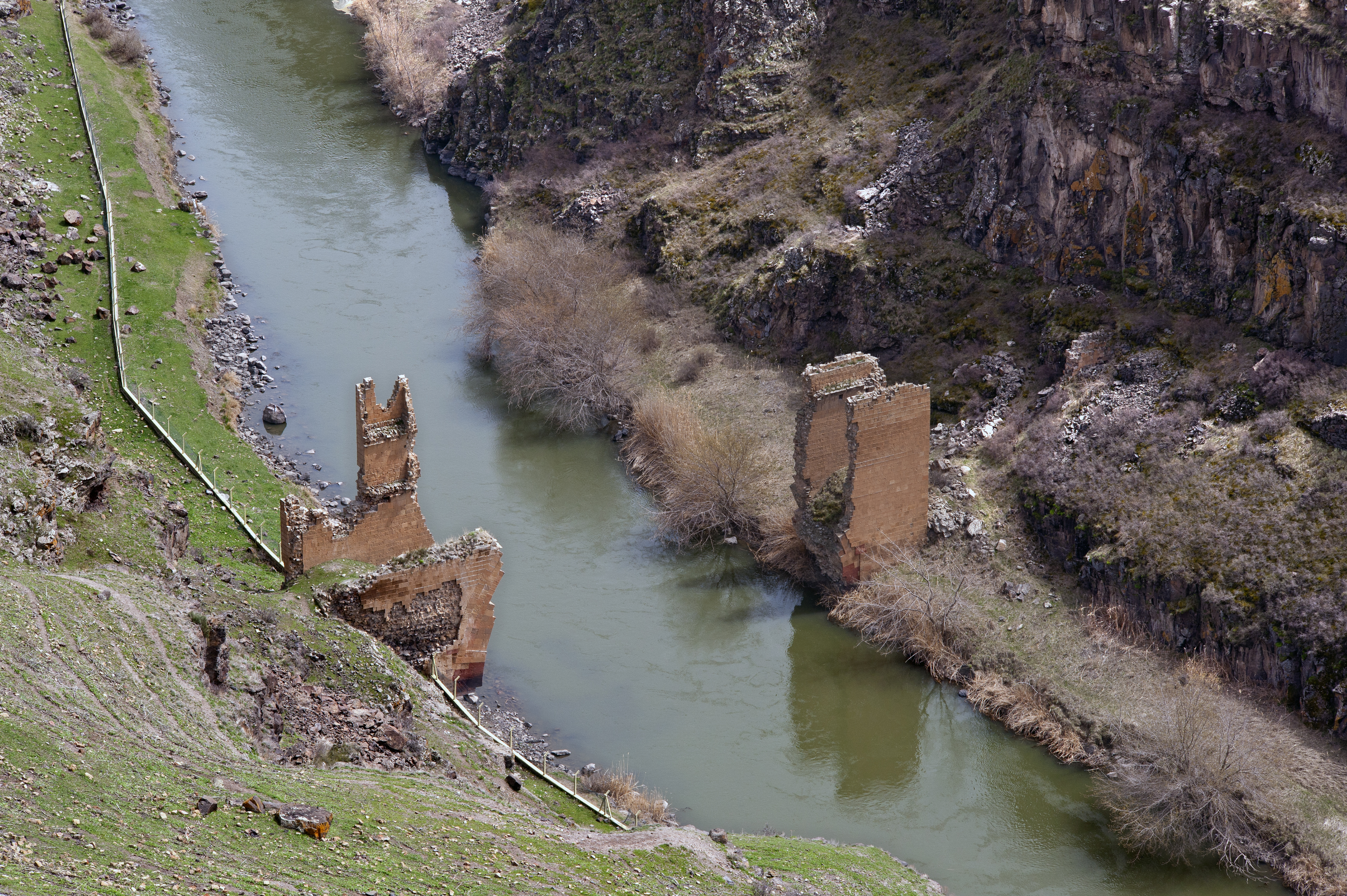
English: Ruins of the bridge over Akhurian River, Ani, Turkey.
Ελληνικά: Ερείπια της γέφυρας στο ποταμό Ακχουριάν, Ανί, Τουρκία. |
| Թվական | |
| Աղբյուր | Բեռնողի սեփական աշխատանք |
| Հեղինակ | Ggia |
| Իրավունքներ (Նիշքի վերաօգտագործումը) |
Ես, սույն աշխատանքի հեղինակային իրավունքների տերը, այսուհետ այն հրատարակում եմ հետևյալ արտոնագրի ներքո։ Այս նիշքը հասանելի է Creative Commons Attribution-Share Alike 3.0 Unported արտոնագրի ներքո:
|
| Տեսախցիկի տեղագրություն | 40° 30′ 19,81″ Հս. լ., 43° 34′ 12,6″ Աե. ե. | Այս և ուրիշ պատկերներ իրենց տեղագրությամբ OpenStreetMap |
|---|
| Annotations InfoField | This image is annotated: View the annotations at Commons |
112
21
673
1535
4256
2832
English: Turkish border fence.
Ελληνικά: Φράκτης Τουρκικών συνόρων.
58
1655
1538
1110
4256
2832
English: Turkey.
Ελληνικά: Τουρκία.
2240
108
1941
1780
4256
2832
English: Armenia.
Ελληνικά: Αρμενία.
Captions
Add a one-line explanation of what this file represents
Items portrayed in this file
պատկերված
captured with անգլերեն
Nikon D700 անգլերեն
40°30'19.807"N, 43°34'12.601"E
19 Ապրիլի 2011
image/jpeg
checksum անգլերեն
8f6938dda73e7962c30b35d5bd7fd4bc05b439a7
data size անգլերեն
12 595 962 Բայթ
2832 փիքսել
4256 փիքսել
Նիշքի պատմություն
Մատնահարեք օրվան/ժամին՝ նիշքի այդ պահին տեսքը դիտելու համար։
| Օր/Ժամ | Մանրապատկեր | Օբյեկտի չափը | Մասնակից | Մեկնաբանություն | |
|---|---|---|---|---|---|
| ընթացիկ | 09:18, 21 հունվարի 2013 | | 4256 × 2832 (12,01 ՄԲ) | Slick-o-bot | Bot: convert to a non-interlaced jpeg image (see bugzilla:17645) |
| 17:29, 10 Հունիսի 2011 |  | 4256 × 2832 (10,85 ՄԲ) | Ggia | {{Information |Description ={{en|1=Ruins of the bridge over Akhurian River, Ani, Turkey.}} {{el|1=Ερείπια της γέφυρας στο ποταμό Ακχουριάν, Ανί, Τουρκία.}} |Source ={{ow | |
| 17:25, 10 Հունիսի 2011 |  | 4256 × 2832 (10,85 ՄԲ) | Ggia | == {{int:filedesc}} == {{Information |Description ={{en|1=Ruins of the bridge over Akhurian River, Ani, Turkey.}} {{el|1=Ερείπια της γέφυρας στο ποταμό Ακχουριάν, Ανί, Τουρκία.} |
Նիշքի օգտագործում
Հետևյալ 3 էջերը հղվում են այս նիշքին՝
Նիշքի համընդհանուր օգտագործում
Հետևյալ այլ վիքիները օգտագործում են այս նիշքը՝
- Օգտագործումը ar.wikipedia.org կայքում
- Օգտագործումը bg.wikipedia.org կայքում
- Օգտագործումը ca.wikipedia.org կայքում
- Օգտագործումը el.wikipedia.org կայքում
- Օգտագործումը en.wikipedia.org կայքում
- Օգտագործումը en.wikivoyage.org կայքում
- Օգտագործումը eo.wikipedia.org կայքում
- Օգտագործումը et.wikipedia.org կայքում
- Օգտագործումը fa.wikipedia.org կայքում
- Օգտագործումը fr.wikipedia.org կայքում
- Օգտագործումը he.wikipedia.org կայքում
- Օգտագործումը hu.wikipedia.org կայքում
- Օգտագործումը it.wikipedia.org կայքում
- Օգտագործումը kk.wikipedia.org կայքում
- Օգտագործումը lt.wikipedia.org կայքում
- Օգտագործումը nl.wikipedia.org կայքում
- Օգտագործումը no.wikipedia.org կայքում
- Օգտագործումը ru.wikipedia.org կայքում
- Օգտագործումը simple.wikipedia.org կայքում
- Օգտագործումը sv.wikipedia.org կայքում
- Օգտագործումը tr.wikipedia.org կայքում
- Օգտագործումը uk.wikipedia.org կայքում
- Օգտագործումը uz.wikipedia.org կայքում
- Օգտագործումը www.wikidata.org կայքում
Մետատվյալներ
Նիշքը պարունակում է ընդարձակ տվյալները, հավանաբար ավելացված թվային լուսանկարչական ապարատի կամ սկաների կողմից, որոնք օգտագործվել են նկարը ստեղծելու կամ թվայնացնելու համար։
Եթե նիշքը ձևափոխվել է ստեղծումից ի վեր, ապա որոշ տվյալները կարող են չհամապատասխանել ձևափոխված նիշքին։
| Camera manufacturer | NIKON CORPORATION |
|---|---|
| Camera model | NIKON D700 |
| Author | {georgios.giannopoulos at gmail.com} |
| Copyright holder |
|
| Exposure time | 1/800 sec (0,00125) |
| F Number | f/8 |
| ISO speed rating | 200 |
| Date and time of data generation | 12:38, 19 Ապրիլի 2011 |
| Lens focal length | 105 mm |
| Latitude | 40° 30′ 19,81″ N |
| Longitude | 43° 34′ 12,6″ E |
| Altitude | 1485 meters above sea level |
| Orientation | Normal |
| Horizontal resolution | 240 dpi |
| Vertical resolution | 240 dpi |
| File change date and time | 20:03, 10 Հունիսի 2011 |
| Exposure Program | Manual |
| Exif version | 2.21 |
| Date and time of digitizing | 12:38, 19 Ապրիլի 2011 |
| APEX shutter speed | 9,643856 |
| APEX aperture | 6 |
| APEX exposure bias | 0 |
| Maximum land aperture | 0 APEX (f/1) |
| Metering mode | Pattern |
| Light source | Fine weather |
| Flash | Flash did not fire |
| DateTime subseconds | 16 |
| DateTimeOriginal subseconds | 16 |
| DateTimeDigitized subseconds | 16 |
| Color space | Uncalibrated |
| Sensing method | One-chip color area sensor |
| File source | Digital still camera |
| Scene type | A directly photographed image |
| Custom image processing | Normal process |
| Exposure mode | Manual exposure |
| White balance | Manual white balance |
| Digital zoom ratio | 1 |
| Focal length in 35 mm film | 105 mm |
| Scene capture type | Standard |
| Scene control | None |
| Contrast | Normal |
| Saturation | Normal |
| Sharpness | Normal |
| Subject distance range | Unknown |
| GPS time (atomic clock) | 09:38 |
| Satellites used for measurement | 09 |
| Geodetic survey data used | WGS 84 |
| GPS date | 19 Ապրիլի 2011 |
| GPS tag version | 0.0.2.2 |
| Lens used | 0.0 mm f/0.0 |
| Serial number of camera | 2080897 |
| Date metadata was last modified | 23:03, 10 Հունիսի 2011 |
| Rating (out of 5) | 0 |
| Unique ID of original document | C8335C98EE782A3EA4BC9992277F248B |
| IIM version | 31 864 |