Datoteka:East-Hem_1025ad.jpg
From Wikipedia, the free encyclopedia
Vidi sliku u punoj veličini (3.240 × 1.903 piksela, veličina datoteke: 3,16 MB, MIME tip: image/jpeg)
| Ova je datoteka sa Zajedničkog poslužitelja i mogu je rabiti drugi projekti. Opis s njezine stranice s opisom datoteke prikazan je ispod. |

|
This historical map image could be re-created using vector graphics as an SVG file. This has several advantages; see Commons:Media for cleanup for more information. If an SVG form of this image is available, please upload it and afterwards replace this template with
{{vector version available|new image name}}.
It is recommended to name the SVG file “East-Hem 1025ad.svg”—then the template Vector version available (or Vva) does not need the new image name parameter. |
 | This historical map image was uploaded in the JPEG format even though it consists of non-photographic data. This information could be stored more efficiently or accurately in the PNG or SVG format. If possible, please upload a PNG or SVG version of this image without compression artifacts, derived from a non-JPEG source (or with existing artifacts removed). After doing so, please tag the JPEG version with {{Superseded|NewImage.ext}} and remove this tag. This tag should not be applied to photographs or scans. If this image is a diagram or other image suitable for vectorisation, please tag this image with {{Convert to SVG}} instead of {{BadJPEG}}. If not suitable for vectorisation, use {{Convert to PNG}}. For more information, see {{BadJPEG}}. |  |
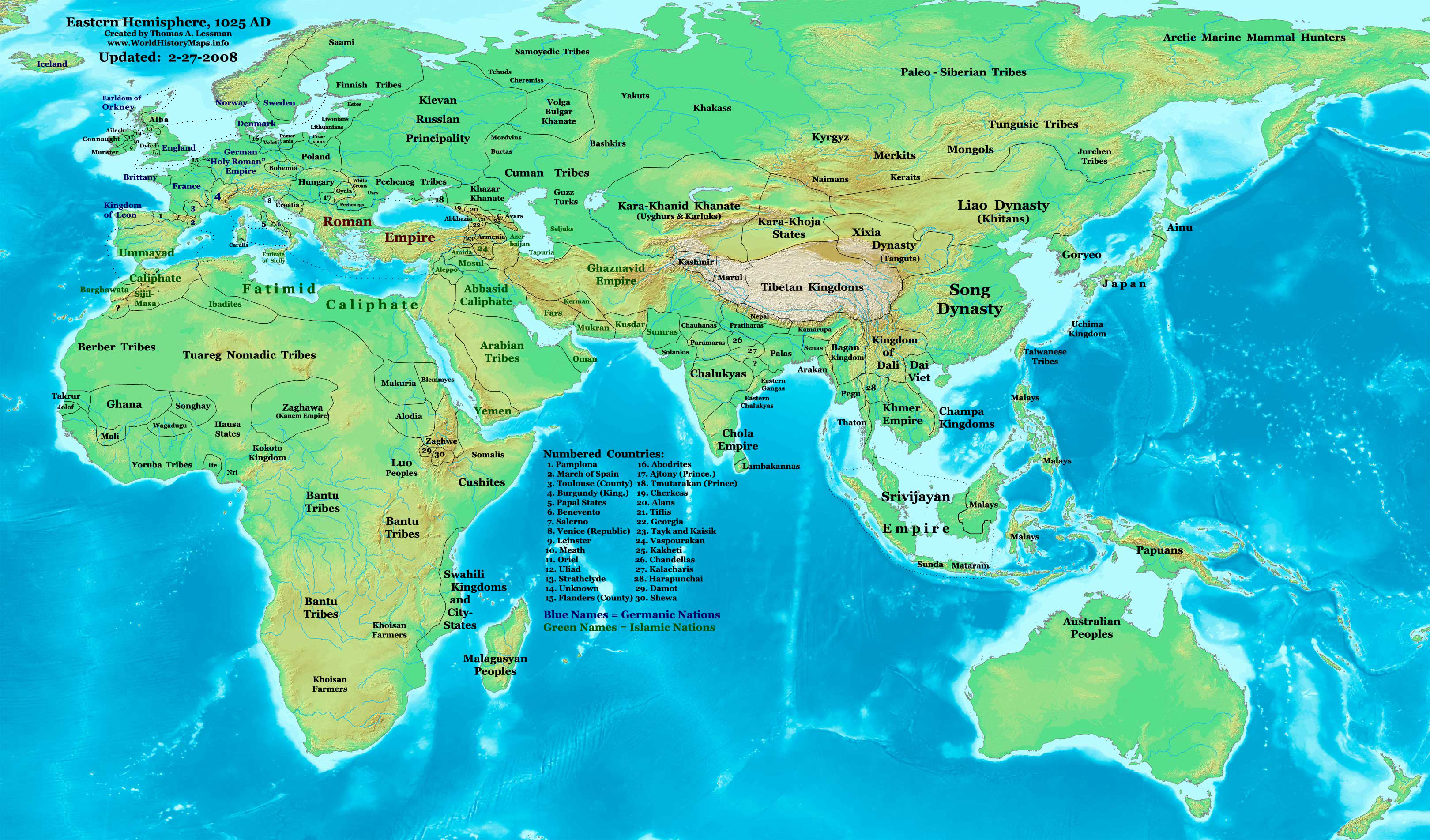
| OpisEast-Hem 1025ad.jpg | Eastern Hemisphere in 1025 AD. |
| Izvor | self-made (For reference information, see the Map Source References section below.) |
| Autor | Thomas Lessman (Contact!) |
| Dopuštenje (Naknadna uporaba ove datoteke) |
Ja, nositelj autorskog prava za ovo djelo, ovime ga objavljujem pod sljedećom licencijom: Ova datoteka je licencirana pod Creative Commons Imenovanje-Dijeli pod istim uvjetima 3.0 nelokaliziranom licencijom.
|
| Ostale inačice | see East-Hem_1025ad.jpg file history on Wikipedia. |
Sadržaj
Map Summary
Original Source URL: http://www.thomaslessman.com/History/images/East-Hem_1025ad.jpg.
This map of the Eastern Hemisphere in 1025 AD was created by Thomas Lessman, based on information from the sources listed below. This map is free for educational use (see Permission info above). When using this map, please mention that it is available for free at www.WorldHistoryMaps.info.
Map Source References
- Remember, sources often conflict with each other. This map is only as accurate as the information that is available to me. To report any errors or to help further this work, please click here, or email Thomas Lessman at talessman@yis.us
References for information contained in this map:
1. Borders of Europe are mostly derived from the www.Euratlas.com map of Europe in 1000 AD.
- (Please note: Bogomolov.PL has done a great job of showing me possible discrepancies in my north European borders compared to this source, due to the differences in the geographical layout of the maps.)
2. Borders of Asian countries derive from various Wikipedia articles and Google history map searches.
3. Fringe areas like Africa, Australia, Siberia, etc. derive from various articles in Wikipedia.
4. Much of the information in this map was cross-checked with Bruce Gordon's Regnal Chronologies.
Other Maps by Thomas Lessman
| Maps of the eastern hemisphere showing history
Bold dates are available on Wikimedia or Wikipedia. | ||
| Primeval | ||
| Ancient
|
·| 600 BC | 550 BC | 527 BC | 500 BC |
400 BC | ·| 1 AD | 50 AD | 100 AD | 200 AD | 300 AD | | |
| Medieval |
·| 500 AD | 565 AD | 600 AD | 700 AD | | |
| Modern |
·| 1500 AD | · * For historical maps of the whole world, | |
| history links talk edit view | ||
Izvorna evidencija postavljanja
- 2008-01-21 22:17 Talessman 3240×1903×8 (795129 bytes) Corrected borders of Southeast Asia, Africa, Scandinavia, and added more info for East Asia and Africa.
- 2007-12-05 20:33 Talessman 3240×1903×8 (774637 bytes) Corrected borders for Mongolia, added names of smaller countries (with numbered legend), added more info for Africa, corrected information for Indonesia.
- 2007-11-09 15:14 Talessman 3240×1903×8 (727501 bytes) Corrected borders of Srivijaya, Sudan, and Ethiopia, also added info on other African tribes and nations, also added info for far eastern islands.
- 2007-09-26 16:26 Talessman 2880×1692×8 (571380 bytes) Author: Thomas A. Lessman. Source URL: http://www.ThomasLessman.com/History/images/East-Hem_1025ad.jpg. Image was created by me (Thomas Lessman) based on historical information located on Wikipedia, as well as information from maps located in Wikipedia an
- 2007-09-12 21:54 Talessman 2880×1692×8 (558662 bytes) Author: Thomas A. Lessman. Source URL: http://www.ThomasLessman.com/History/images/East-Hem_1025ad.jpg. Image was created by me (Thomas Lessman) based on historical information located on Wikipedia, as well as information from maps located in Wikipedia an
Opisi
Predmeti prikazani u ovoj datoteci
motiv
Određene vrijednosti bez stavke na projektu Wikipodatci
Povijest datoteke
Kliknite na datum/vrijeme kako biste vidjeli datoteku kakva je tada bila.
| Datum/Vrijeme | Minijatura | Dimenzije | Suradnik | Komentar | |
|---|---|---|---|---|---|
| sadašnja | 13:09, 16. siječnja 2009. | | 3.240 × 1.903 (3,16 MB) | Ukabia | {{Information |Description= |Source= |Date= |Author= |Permission= |other_versions= }} |
| 23:27, 9. svibnja 2008. |  | 3.240 × 1.903 (778 KB) | Talessman | {{Information |Description=Eastern Hemisphere in 1025 AD. |Source=self-made |Author=User:Talessman |Permission={{self|cc-by-sa-3.0}} }} |
Uporaba datoteke
Nijedna stranica ne rabi ovu datoteku.
Globalna uporaba datoteke
Sljedeći wikiji rabe ovu datoteku:
- Uporaba na ar.wikipedia.org
- Uporaba na arz.wikipedia.org
- Uporaba na azb.wikipedia.org
- Uporaba na be.wikipedia.org
- Uporaba na bs.wikipedia.org
- Uporaba na ceb.wikipedia.org
- Uporaba na de.wikiversity.org
- Uporaba na en.wikipedia.org
- 11th century
- User:Tompw/sandbox10
- User:Talessman/Maps
- User talk:Talessman/Maps
- User:Benjamin Trovato/sandbox
- List of states during the Middle Ages
- List of political entities in the 11th century
- User:Navops47/sandbox10
- List of countries by population in 1000
- Champa–Đại Cồ Việt war (982)
- User:Falcaorib/Ancient East Hemisphere
- Uporaba na es.wikipedia.org
- Uporaba na fa.wikipedia.org
- Uporaba na fr.wikipedia.org
- Uporaba na gl.wikipedia.org
- Uporaba na he.wikipedia.org
- Uporaba na hu.wikipedia.org
- Uporaba na io.wikipedia.org
- Uporaba na lt.wikipedia.org
- Uporaba na mk.wikipedia.org
- Uporaba na mr.wikipedia.org
- Uporaba na my.wikipedia.org
- Uporaba na pnb.wikipedia.org
- Uporaba na ps.wikipedia.org
- Uporaba na ro.wikipedia.org
- Uporaba na rue.wikipedia.org
- Uporaba na ru.wikipedia.org
- Uporaba na shn.wikipedia.org
- Uporaba na si.wikipedia.org
- Uporaba na sv.wikipedia.org
- Uporaba na sw.wikipedia.org
- Uporaba na tg.wikipedia.org
- Uporaba na th.wikipedia.org
- Uporaba na tl.wikipedia.org
- Uporaba na ur.wikipedia.org
Pogledajte globalnu uporabu ove datoteke.
Metapodatci
Ova datoteka sadržava dodatne podatke koje je vjerojatno dodala digitalna kamera ili skener u procesu snimanja odnosno digitalizacije. Ako je datoteka mijenjana, podatci možda nisu u skladu sa stvarnim stanjem.
| Orijentacija kadra | Normalno |
|---|---|
| Vodoravna razlučivost | 72 dpi |
| Okomita razlučivost | 72 dpi |
| Korišteni softver | Adobe Photoshop CS3 Macintosh |
| Datum posljednje promjene datoteke | 11:07, 16. siječnja 2009. |
| Kolor prostor | Nekalibrirano |