चित्र:Normans_possessions_12century-fr.png
From Wikipedia, the free encyclopedia
इस पूर्वावलोकन का आकार: 800 × 581 पिक्सेल। दूसरे रेसोल्यूशन्स: 320 × 232 पिक्सेल | 640 × 465 पिक्सेल | 1,024 × 743 पिक्सेल | 1,394 × 1,012 पिक्सेल।
मूल चित्र ((1,394 × 1,012 पिक्सेल, फ़ाइल का आकार: 1.02 MB, MIME प्रकार: image/png))
|
|
यह फ़ाइल विकिमेडिया कॉमन्स से है। वहाँ पर इसका विवरण पृष्ठ निम्नोक्त है। कॉमन्स मुक्त लाइसेंसों के अंतर्गत उपलब्ध मीडिया फ़ाइलों का संग्रह है। आप भी इसमें मदद कर सकते हैं। |
सारांश
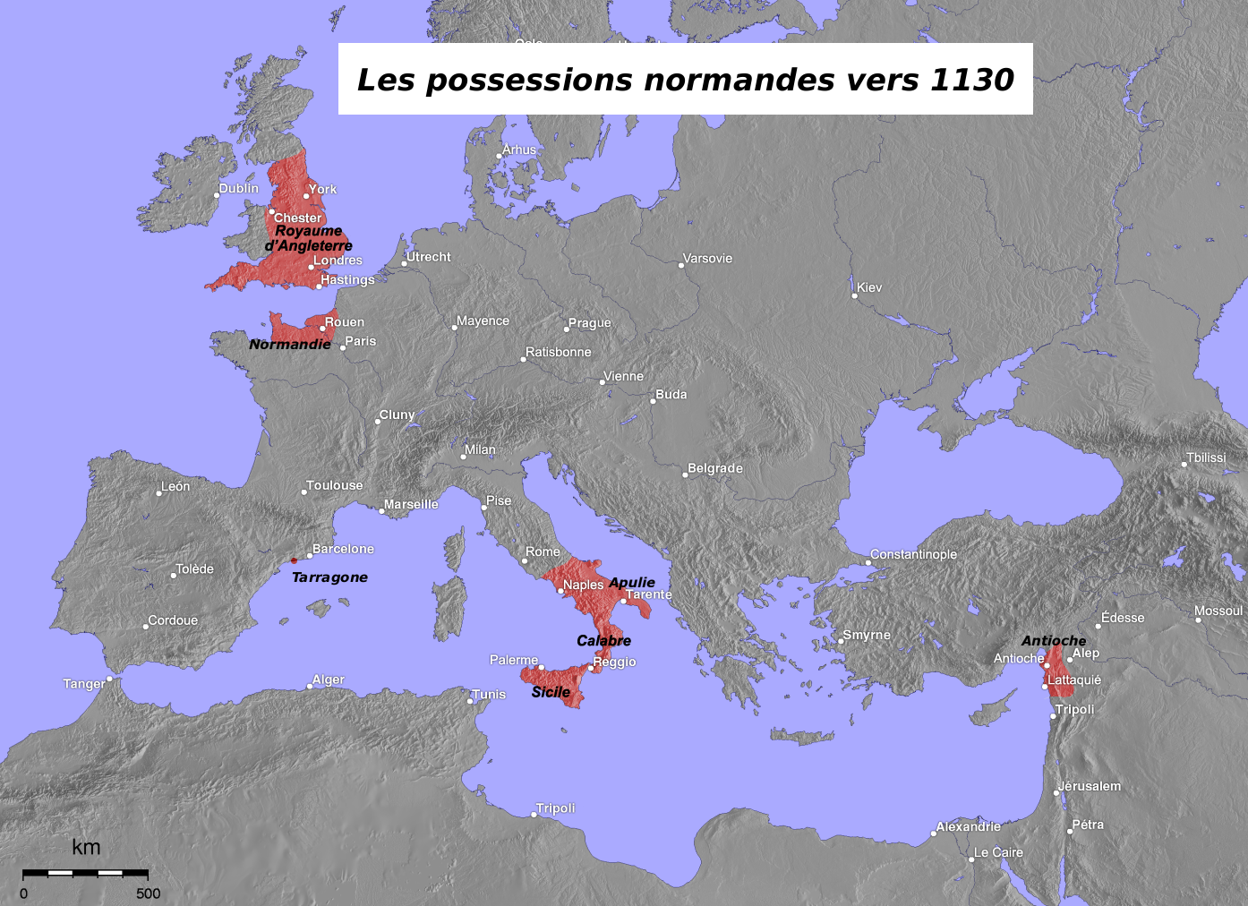
| विवरणNormans possessions 12century-fr.png | Map in French of the Normans' possessions in the 12th century |
| दिनांक | April 2005 (original) – August 2006 (translation) |
| स्रोत | Image:Normannen.png created by de:Captain Blood (originally taken from the German Wikipedia) |
| लेखक |
Original map : de:Captain Blood Translation : Eric Gaba (Sting) |
| अनुमति (इस चित्र का पुनः उपयोग करना) |
GFDL |
| दूसरे संस्करण |
Derivative works of this file: Normans possessions 12century es.png
|


Français : * Sujet : Carte en français des possessions normandes au XIIe siècle ;
- Source : Image:Normannen.png créée par de:Captain Blood (originellement issue de la Wikipédia germanophone) ;
- Autres versions disponibles :
- germanophone : Image:Normannen.png ;
- Auteurs :
- carte originale : de:Captain Blood ;
- traduction : Eric Gaba (fr:Sting) ;
- Dates :
- originale : Avril 2005 ;
- traduction : Août 2006.
This map was improved or created by the Wikigraphists of the Graphic Lab (fr). You can propose images to clean up, improve, create or translate as well. |
लाइसेंस
The map has been created with the Generic Mapping Tools: https://www.generic-mapping-tools.org/ using one or more of these public-domain datasets for the relief:
বাংলা ∙ English ∙ español ∙ français ∙ italiano ∙ 日本語 ∙ македонски ∙ sicilianu ∙ 中文(简体) ∙ 中文(繁體) ∙ +/− |

|
इस दस्तावेज़ को Free Software Foundation द्वारा प्रकाशित GNU मुक्त प्रलेख लाइसेंस के संस्करण 1.2 या नए (बिना किसी अपरिवर्तनीय अनुभागों और अगले या पिछले आवरण के टेक्स्ट के) के अंतर्गत प्रतिलिपि बनाने, बाँटने और/या बदलने की अनुमति प्रदान की जाती है। इस लाइसेंस की एक प्रतिलिपि GNU मुक्त प्रलेख लाइसेंस नामक अनुभाग में शामिल है।http://www.gnu.org/copyleft/fdl.htmlGFDLGNU Free Documentation Licensetruetrue |
| इस फ़ाइल को क्रिएटिव कॉमन्स श्रेय-समानसांझा 3.0 अनरिपोर्टेड लाइसेंस के अंतर्गत लाइसेंस किया गया है। | ||
| ||
| This licensing tag was added to this file as part of the GFDL licensing update.http://creativecommons.org/licenses/by-sa/3.0/CC BY-SA 3.0Creative Commons Attribution-Share Alike 3.0truetrue |
Captions
Add a one-line explanation of what this file represents
Items portrayed in this file
चित्रण
चित्र का इतिहास
फ़ाइलका पुराना अवतरण देखने के लिये दिनांक/समय पर क्लिक करें।
| दिनांक/समय | थंबनेल | आकार | सदस्य | प्रतिक्रिया | |
|---|---|---|---|---|---|
| वर्तमान | 22:51, 8 जून 2010 | | 1,394 × 1,012 (1.02 MB) | Ras67 | cropped |
| 13:54, 24 अक्टूबर 2008 |  | 1,400 × 1,018 (5.45 MB) | Bourrichon | + Tarragone | |
| 13:49, 24 अक्टूबर 2008 |  | 1,400 × 1,018 (5.45 MB) | Bourrichon | + Tarragone | |
| 18:50, 30 अगस्त 2006 |  | 1,400 × 1,018 (1.13 MB) | Sting | {{Information |Description=Map in French of the Normans possessions in the 12th century |Source=Image:Normannen.png created by de:Captain Blood (originally taken from the German Wikipedia) |Date=April 2005 (original) � |
चित्र का उपयोग
निम्नलिखित पन्ने इस चित्र से जुडते हैं :
चित्र का वैश्विक उपयोग
इस चित्र का उपयोग इन दूसरे विकियों में किया जाता है:
- af.wikipedia.org पर उपयोग
- an.wikipedia.org पर उपयोग
- bg.wikipedia.org पर उपयोग
- eu.wikipedia.org पर उपयोग
- fr.wikipedia.org पर उपयोग
- Normandie
- Baronnage anglo-normand
- Monde méditerranéen au XIIe siècle
- Discussion Projet:Haut Moyen Âge/Archives2 août-octobre 2006
- Wikipédia:Atelier graphique/Cartes/Archives/octobre 2008
- Discussion:An mille
- Utilisateur:Bourrichon/Didacticiel : recadrer ou découper une carte ou une image
- Wikipédia:Atelier graphique/Didacticiels cartographiques/Didacticiel pour recentrer ou découper une carte ou une image
- Dynastie des Anges
- Famille Poerio
- ga.wikipedia.org पर उपयोग
- ja.wikipedia.org पर उपयोग
- mk.wikipedia.org पर उपयोग
- ms.wikipedia.org पर उपयोग
- nn.wikipedia.org पर उपयोग
- pcd.wikipedia.org पर उपयोग
- sl.wikipedia.org पर उपयोग
- ta.wikipedia.org पर उपयोग
- zh.wikipedia.org पर उपयोग