קובץ:Clementine_albedo_simp750.jpg
ויקיפדיה האנציקלופדיה encyclopedia
גודל התצוגה המקדימה הזאת: 800 × 400 פיקסלים. רזולוציות אחרות: 320 × 160 פיקסלים | 640 × 320 פיקסלים | 1,080 × 540 פיקסלים.
לקובץ המקורי (1,080 × 540 פיקסלים, גודל הקובץ: 204 ק"ב, סוג MIME: image/jpeg)
| זהו קובץ שמקורו במיזם ויקישיתוף. תיאורו בדף תיאור הקובץ המקורי (בעברית) מוצג למטה. |
תקציר
| תיאורClementine albedo simp750.jpg |
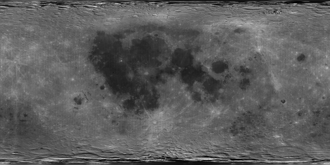
English: A global albedo map of the Moon obtained from the Clementine mission. The dark regions are the lunar maria, whereas the lighter regions are the highlands. The image is a cylindrical projection, with longitude increasing left to right from -180 E to 180 E and latitude decreasing from top to bottom from 90 N to 90 S. The center of the image corresponds to the mean sub-Earth point, 0 N and 0 E. |
| מקור | direct source found on here |
| יוצר | Image processing by the U.S. Geological Survey in Flagstaff, Arizona. |
רישיון
| Public domainPublic domainfalsefalse |
This image is in the public domain in the United States because it only contains materials that originally came from the United States Geological Survey, an agency of the United States Department of the Interior. For more information, see the official USGS copyright policy.
Bahasa Indonesia ∙ català ∙ čeština ∙ Deutsch ∙ eesti ∙ English ∙ español ∙ français ∙ galego ∙ italiano ∙ Nederlands ∙ português ∙ polski ∙ sicilianu ∙ suomi ∙ Tiếng Việt ∙ Türkçe ∙ български ∙ македонски ∙ русский ∙ മലയാളം ∙ 한국어 ∙ 日本語 ∙ 中文 ∙ 中文(简体) ∙ 中文(繁體) ∙ العربية ∙ فارسی ∙ +/− |
כיתובים
נא להוסיף משפט שמסביר מה הקובץ מייצג
פריטים שמוצגים בקובץ הזה
מוצג
image/jpeg
209,090 בית
540 פיקסל
1,080 פיקסל
היסטוריית הקובץ
ניתן ללחוץ על תאריך/שעה כדי לראות את הקובץ כפי שנראה באותו זמן.
| תאריך/שעה | תמונה ממוזערת | ממדים | משתמש | הערה | |
|---|---|---|---|---|---|
| נוכחית | 13:39, 4 באפריל 2007 | | 540 × 1,080 (204 ק"ב) | Yonatanh | == Summary == {{Information |Description={{en|A global albedo map of the Moon obtained from the Clementine mission. The dark regions are the lunar maria, whereas the lighter regions are the highlands. The image is a cylindrical projection, with longitude |
שימוש בקובץ
הדפים הבאים משתמשים בקובץ הזה:
שימוש גלובלי בקובץ
אתרי הוויקי השונים הבאים משתמשים בקובץ זה:
- שימוש באתר af.wikipedia.org
- שימוש באתר ba.wikibooks.org
- שימוש באתר bn.wikibooks.org
- שימוש באתר ca.wikipedia.org
- שימוש באתר da.wikipedia.org
- שימוש באתר en.wikipedia.org
- שימוש באתר en.wikibooks.org
- שימוש באתר es.wikipedia.org
- שימוש באתר eu.wikipedia.org
- שימוש באתר fi.wikipedia.org
- שימוש באתר gl.wikipedia.org
- שימוש באתר ja.wikibooks.org
- שימוש באתר ro.wikipedia.org
- שימוש באתר sl.wikipedia.org
- שימוש באתר sr.wikipedia.org
- שימוש באתר ta.wikipedia.org
- שימוש באתר zh.wikipedia.org
מטא־נתונים
קובץ זה מכיל מידע נוסף, שכנראה הגיע ממצלמה דיגיטלית או מסורק שבהם הקובץ נוצר או עבר דיגיטציה.
אם הקובץ שונה ממצבו הראשוני, כמה מהנתונים להלן עלולים שלא לשקף באופן מלא את הקובץ הנוכחי.
| _error | 0 |
|---|