File:Majak_Satellitenkarte.jpg
ויקיפדיה האנציקלופדיה encyclopedia
גודל התצוגה המקדימה הזאת: 800 × 509 פיקסלים. רזולוציות אחרות: 320 × 204 פיקסלים | 640 × 408 פיקסלים | 1,024 × 652 פיקסלים | 1,448 × 922 פיקסלים.
לקובץ המקורי (1,448 × 922 פיקסלים, גודל הקובץ: 292 ק"ב, סוג MIME: image/jpeg)
| זהו קובץ שמקורו במיזם ויקישיתוף. תיאורו בדף תיאור הקובץ המקורי (בעברית) מוצג למטה. |
| תיאורMajak Satellitenkarte.jpg |
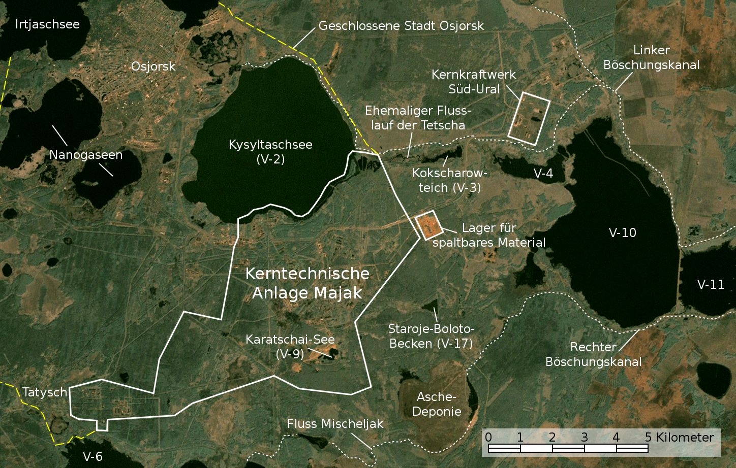
English: Satellite image/map of the Mayak nuclear facility, the closed town of Ozyorsk/Ozersk (Chelyabinsk-65), different lakes and reservoirs, and the South Urals nuclear power plant.
Based on a screenshot from NASA World Wind (Landsat Global Mosaic visual layer), color corrected.
Deutsch: Satellitenfoto/Karte der kerntechnischen Anlage Majak, der geschlossenen Stadt Osjorsk (Tscheljabinsk-65), verschiedenen Seen und Reservoire sowie dem Kernkraftwerk Süd-Ural.
Basierend auf einem Screenshot aus NASA World Wind (Landsat Global Mosaic visual layer), farbkorrigiert. |
|||||||
| תאריך יצירה | ||||||||
| מקור | NASA World Wind screenshot (Landsat Global Mosaic visual layer) | |||||||
| יוצר | NASA, Jan Rieke (color correction, borders and labels) | |||||||
| אישורים והיתרים (שימוש חוזר בקובץ זה) |
|
|||||||
| גרסאות אחרות | File:Satellite image map of Mayak.jpg |

| זוהי תמונה מרוטשת, זאת אומרת שהתמונה שונתה בצורה דיגיטלית מהמקור. Modifications: Farbkorrektur, Bezeichnungen und Grenzen. השינוי בוצע על ידי JanRieke.
|
| מיקום המצלמה | 55° 42′ 58.57″ N, 60° 49′ 54.34″ E | תמונה זו ותמונות נוספות במיקום: OpenStreetMap |
|---|
Nennung der Urheber bei Weiterverwendung außerhalb der Wikipedia wäre schön, ist aber nicht erforderlich.
תוכן עניינים
Quellen
Hauptquellen
- Igor Kudrik, Aleksandr Nikitin, Charles Digges, Nils Bøhmer, Vladislav Larin, Vladimir Kuznetsov: The Russian Nuclear Industry – The Need for Reform. Bellona Report Volume 4:2004. Bellona Foundation, S. 47–69, 1. November 2004
- Map of the system of dams and drainage channels at Mayak., in: AMAP Assessment Report: Arctic Pollution Issues, Arctic Monitoring & Assessment Programme, Working Group of the Arctic Council, 1998
- Dmitriy Burmistrov, Mira Kossenko, Richard Wilson: Radioactive Contamination of the Techa River and its Effects. archive copy at the Wayback Machine Technology, Vol. 7, S. 553-575, 2000
Weitere Quellen
Position von V-6
- B. Gusakov, A. Demin, M. Zawadzki, V. Kalinkin, A. Kirsanov, N. Shafrova: Решение экологических проблем Теченского каскада водоемов на ПО "Маяк"., 19. Dezember 2006
Aschedeponie
- A. R. Hutter: Radioactive contamination distribution in the bottom sediments and water of the Mishelyak River[dead link], Journal of Radioanalytical and Nuclear Chemistry, 2001
- O. Aleksandrova: Natural remediation of surface water systems used as deposits of nuclear industry waste by humic substances, Dissertation, Universität Osnabrück, 2009
| Annotations InfoField | This image is annotated: View the annotations at Commons |
כיתובים
נא להוסיף משפט שמסביר מה הקובץ מייצג
Image satellite de l'installation nucléaire de Mayak, de la ville fermée d'Ozyorsk/Ozersk (Chelyabinsk-65), de différents lacs et réservoirs et de la centrale nucléaire du sud de l'Oural.
פריטים שמוצגים בקובץ הזה
מוצג
14 במאי 2010
55°42'58.57"N, 60°49'54.34"E
היסטוריית הקובץ
ניתן ללחוץ על תאריך/שעה כדי לראות את הקובץ כפי שנראה באותו זמן.
| תאריך/שעה | תמונה ממוזערת | ממדים | משתמש | הערה | |
|---|---|---|---|---|---|
| נוכחית | 05:48, 28 בנובמבר 2010 | | 922 × 1,448 (292 ק"ב) | JanRieke | Yellow color for closed city borders, slightly reduced brightness |
| 03:53, 14 בנובמבר 2010 |  | 922 × 1,448 (282 ק"ב) | JanRieke | Included courses of rivers, minor other changes | |
| 02:09, 15 במאי 2010 |  | 922 × 1,448 (276 ק"ב) | JanRieke | {{Information |Description={{en|1=Satellite image/map of the Mayak nuclear facility, the closed town of Ozyorsk/Ozersk (Chelyabinsk-65), different lakes and reservoirs, and the South Urals nuclear power plant. Based on a screenshot from NASA World Wind (L |
שימוש בקובץ
![]() אין בוויקיפדיה דפים המשתמשים בקובץ זה.
אין בוויקיפדיה דפים המשתמשים בקובץ זה.
שימוש גלובלי בקובץ
אתרי הוויקי השונים הבאים משתמשים בקובץ זה:
- שימוש באתר arz.wikipedia.org
- שימוש באתר ba.wikipedia.org
- שימוש באתר ceb.wikipedia.org
- שימוש באתר da.wikipedia.org
- שימוש באתר de.wikipedia.org
- שימוש באתר de.wikivoyage.org
- שימוש באתר es.wikipedia.org
- שימוש באתר fr.wikipedia.org
- שימוש באתר hu.wikipedia.org
- שימוש באתר ja.wikipedia.org
- שימוש באתר nn.wikipedia.org
- שימוש באתר ru.wikipedia.org
- שימוש באתר sr.wikipedia.org
- שימוש באתר uk.wikipedia.org
- שימוש באתר www.wikidata.org
מטא־נתונים
קובץ זה מכיל מידע נוסף, שכנראה הגיע ממצלמה דיגיטלית או מסורק שבהם הקובץ נוצר או עבר דיגיטציה.
אם הקובץ שונה ממצבו הראשוני, כמה מהנתונים להלן עלולים שלא לשקף באופן מלא את הקובץ הנוכחי.
| _error | 0 |
|---|